geo.wikisort.org - Reservoir
Øyeren is a lake in the Glomma River watershed, southeast of Lillestrøm. It is located within the municipalities of Enebakk, Skedsmo, Fet, and Rælingen in Akershus county and Spydeberg and Trøgstad municipalities in Østfold county.
| Øyeren | |
|---|---|
 | |
 Øyeren | |
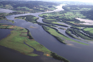
 Map of Øyeren and surrounds | |
| Location | Akershus and Østfold counties, Norway |
| Coordinates | 59°51′26″N 11°09′48″E |
| Type | Natural lake |
| Basin countries | Norway |
| Surface area | 84.74 km2 (32.72 sq mi) |
| Max. depth | 71 m (233 ft) |
| Shore length1 | 165.47 km (102.82 mi) |
| Surface elevation | 101 m (331 ft) |
| References | NVE |
Ramsar Wetland | |
| Official name | Nordre Oyeren |
| Designated | 24 July 1985 |
| Reference no. | 307[1] |
| 1 Shore length is not a well-defined measure. | |
Lake Øyeren is the ninth largest lake by area in Norway with a surface area of 84.7 square kilometers (32.7 square miles). It is 101 meters (331 feet) above sea level and 71 meters (233 feet) deep.
The name
The name of the lake (Norse Øyir) is derived from øy f 'island; flat and fertile land along a waterside'.
Nordre Øyeren nature preserve
An area that includes parts of the northern ("nordre") end of the lake is an established nature preserve, listed as a Ramsar site.
References
- "Nordre Oyeren". Ramsar Sites Information Service. Retrieved 25 April 2018.
External links
- Øyeren information center (Norwegian )
- Nordre Øyeren natur preserve (Norwegian )
- Ramsar Sites Information on Nordre Øyeren (English )
| Authority control |
|
|---|
This article related to a lake in Viken in Norway is a stub. You can help Wikipedia by expanding it. |
This article related to a protected area in Europe is a stub. You can help Wikipedia by expanding it. |
На других языках
[de] Øyeren
Der Øyeren ist der neuntgrößte Binnensee Norwegens. Er befindet sich in den Kommunen Indre Østfold, Lillestrøm, Rælingen und Enebakk in Viken. Zu- und Abfluss ist die Glomma. Zusammen mit den Flüssen Leira und Nitelva bildet die Glomma das größte Binnendelta am nördlichen Ende des Sees; Teile dieses Feuchtgebiets wurden zum Naturreservat erklärt (1975: Nordre Øyeren Naturreservat und 1992 Sørumsneset Naturreservat).- [en] Øyeren
[ru] Эйерен
Эйерен[4] (норв. Øyeren[1]) — проточное озеро на юге Норвегии. Располагается к юго-востоку от Осло[5], на территории коммун Релинген, Лиллестрём[en], Энебакк и Индрэ-Эстфолл[en][6] в фюльке Викен[en]. Одно из крупнейших озёр страны[1], площадь — 73,09[2] (по другим данным — 73,27 км²[1]). Зарегулировано, уровень уреза воды колеблется в пределах от 100,25 до 102,65 м над уровнем моря[1]. Наибольшая глубина составляет 76 м[3] (по другим данным — 71 м[1]) и достигается к югу от центральной части южной половины озера[3]. Площадь водосборного бассейна — 40109,98 км²[2].Другой контент может иметь иную лицензию. Перед использованием материалов сайта WikiSort.org внимательно изучите правила лицензирования конкретных элементов наполнения сайта.
WikiSort.org - проект по пересортировке и дополнению контента Википедии