geo.wikisort.org - Mountains
The Superstition Mountains (Yavapai: Wi:kchsawa) is a range of mountains in Arizona located to the east of the Phoenix metropolitan area. They are anchored by Superstition Mountain, a large mountain that is a popular recreation destination for residents of the Phoenix, Arizona, area. They are roughly bounded by U.S. Route 60 on the south, Arizona State Route 88 on the northwest, and Arizona State Route 188 on the northeast.
| Superstition Wilderness | |
|---|---|
| Wi:kchsawa | |
IUCN category Ib (wilderness area)[1] | |
 Praying Hands Formation | |
| Location | Maricopa / Pinal / Gila counties, Arizona, US |
| Nearest city | Apache Junction, Arizona |
| Coordinates | 33°28′41″N 111°14′20″W |
| Area | 159,757 acres (64,651 ha) |
| Established | 1939 |
| Governing body | United States Forest Service |
History and description
The mountains were once known in Spanish as Sierra de la Espuma ("Foam Mountains").
The range has a maximum elevation of 6,266 ft (1,910 m) and prominence of 1,706 ft (520 m) at Mound Mountain in the far eastern section of the range.[2][3][4]
The mountains are in the federally designated Superstition Wilderness Area, and include a variety of natural features in addition to its namesake mountain. Weavers Needle, a prominent landmark and rock climbing destination set behind and to the east of Superstition Mountain, is a tall eroded volcanic remnant[5] that plays a significant role in the legend of the Lost Dutchman's Gold Mine. Numerous hiking trails cross the mountains from multiple access points, including the Peralta Trailhead, the most popular.[6] Peralta Canyon, on the northeast side of Superstition Mountain, contains a popular trail that leads up to Fremont Saddle, which provides a very picturesque view of Weavers Needle. Miner's Needle is another prominent formation in the wilderness and a popular hiking destination. Lost Dutchman State Park, located on the west side of Superstition Mountain, includes several short hiking and mountain bike trails.
Circlestone includes ancient stone monuments.
As with most of the terrain surrounding the Phoenix metropolitan area, the Superstition Mountains have a desert climate, with high summer temperatures and a handful of perennial sources of water. The elevation in the more remote, eastern portion of the wilderness is higher than the western portion, which lowers temperatures slightly.
Legends
The legend of the Lost Dutchman's Gold Mine centers around the Superstition Mountains. According to the legend, a German immigrant named Jacob Waltz discovered a mother lode of gold in the Superstition Wilderness and revealed its location on his deathbed in Phoenix in 1891 to Julia Thomas, a boarding-house owner who had taken care of him for many years. Several mines have been claimed to be the actual mine that Waltz discovered, but none of those claims have been verified.[5] Waltz was a miner at Vulture Mine, where he likely stole the gold and came up with the secret mine to explain his theft. The legends and lore of the Superstition Mountains can be experienced at the Superstition Mountain Museum[7] on the Apache Trail where artifacts of the Lost Dutchman are on display.
Some Apaches believe that the hole leading down into the lower world, or hell, is located in the Superstition Mountains. Winds blowing from the hole are supposed to be the cause of severe dust storms in the metropolitan region.[8]
Nearby towns and cities
- Apache Junction, Arizona
- Gold Canyon, Arizona
- Mesa, Arizona
- Superior, Arizona
- Tortilla Flat, Arizona
Gallery
 Miners Needle from Bluff Spring Trail. Note prominent bedding planes in the volcanics. (2010)
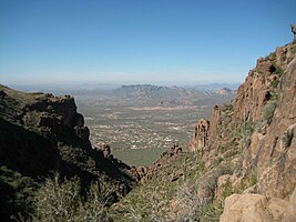 View from the Flatiron hiking trail (2008)
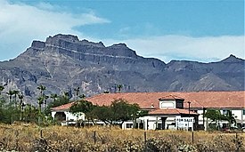 Superstition Mountains From Route 60 at Apache Junction (2021)
 Mining – of gold, silver and especially copper – has historically been an economically significant activity in the mountains (2014)
 A view from the Apache Trail (Arizona State Route 88) in 2016
 Boulder Canyon Trail – Weaver's Needle in distance (2011)
 Petroglyphs in Superstition Wilderness (2007)


See also
- List of wilderness areas of the United States
- List of mountain ranges of Arizona
- Wilderness Act
References
- "Maps | Data Basin". databasin.org. Retrieved 2018-12-28.
- "Mound Mountain, East Superstition Mountains". peakbagger.com. Retrieved 2016-09-02.
- "East Superstition Mountains". peakbagger.com. Retrieved 2016-09-02.
- "Superstition Mountains Benchmark, Western section". peakbagger.com. Retrieved 2016-09-02.
- Kollenborn, Tom (1990). "Weaver's Needle or Picacho?". Archived from the original on 2004-10-30. Retrieved April 1, 2007.
- Carroll, Doug. "Hiking the Supsertitions". Retrieved April 1, 2007.
- Heim, Dave. "Superstition Mountain Museum".
- Vitaliano, Dorothy. 1973. Legends of the Earth, Bloomington: Indiana University Press, pp. 170–171.
External links
- HikeArizona.com: Numbered Trails Map
- Official Apache Trail website: Superstition Mountains
- Tonto National Forest: Superstition Wilderness Area Forest Service information
- Wilderness.net: Superstition Wilderness Area
- GORP.com: Superstition Wilderness
- Ajpl.org: History of the Superstitions
- JustRoughinIt.com: Superstition Wilderness Average Climate
Authority control | |
|---|---|
| General | |
| National libraries | |
На других языках
[de] Superstition Mountains
Die Superstition Mountains (Yavapai: Wi:kchsawa, englisch Superstition = deutsch Aberglaube) sind eine Gebirgskette in Arizona in den Vereinigten Staaten. Sie liegen östlich der Phoenix metropolitan area und befinden sich in der Umgebung des Superstition Mountain, einem Berg, der ein beliebtes Erholungsziel für die Bewohner von Phoenix darstellt.- [en] Superstition Mountains
[fr] Monts de la Superstition
Les monts de la Superstition (Superstition Mountains) sont un groupe de montagnes situé à l'est de Phoenix en Arizona aux États-Unis. Ils sont regroupés autour de la montagne de la Superstition. Le groupe de montagnes appartient au Superstition Wilderness Area, un parc fédéral américain.Другой контент может иметь иную лицензию. Перед использованием материалов сайта WikiSort.org внимательно изучите правила лицензирования конкретных элементов наполнения сайта.
WikiSort.org - проект по пересортировке и дополнению контента Википедии