geo.wikisort.org - Mountains
Mount Weed is a 3,080-metre (10,100-foot) mountain summit located in the Mistaya River valley of Banff National Park, in the Canadian Rockies of Alberta, Canada. Mount Weed is situated at the confluence of Silverhorn Creek and Mistaya River, 3.5 kilometres southwest of Mount Noyes, 4.5 km east of Mistaya Lake, and 14 km north of Bow Lake. Its nearest higher peak is Mount Patterson, 5.82 km (3.62 mi) to the southwest.[5] Patterson stands directly across the Mistaya River valley from Weed, and both are prominent features seen from the Icefields Parkway.
| Mount Weed | |
|---|---|
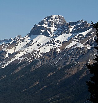
 Mount Weed seen from Icefields Parkway | |
| Highest point | |
| Elevation | 3,080 m (10,100 ft)[1] |
| Prominence | 383 m (1,257 ft)[2] |
| Parent peak | Observation Peak (3174 m)[2] |
| Listing | Mountains of Alberta |
| Coordinates | 51°47′32″N 116°31′41″W[3] |
| Geography | |
Mount Weed Location of Mount Weed in Alberta  Mount Weed Mount Weed (Canada) | |
| Country | Canada |
| Province | Alberta |
| Protected area | Banff National Park |
| Parent range | Murchison Group Canadian Rockies |
| Topo map | NTS 82N15 Mistaya Lake[3] |
| Geology | |
| Age of rock | Cambrian |
| Type of rock | Sedimentary |
| Climbing | |
| First ascent | 1936 by L. Gest, Mr. and Mrs. H. Kingman, H.S. Kingman Jr., W. Kingman, C.Hasler Jr.[2] |
| Easiest route | Scramble[4] |
History
The mountain was named by J. Norman Collie in 1902 for George Marsten Weed (1864-1948) of the Appalachian Mountain Club, who climbed in the Rockies and made several first ascents.[2] Collie and Weed were together in a party which made the first ascent of Mount Forbes on August 10, 1902. The mountain's name was officially adopted in 1928 by the Geographical Names Board of Canada.[3]
The first ascent of the peak was made in 1936 by L. Gest, Mr. and Mrs. H. Kingman, H.S. Kingman Jr., W. Kingman, with Christian Hasler Jr. as guide.[6]
Geology
Like other mountains in Banff Park, the mountain is composed of sedimentary rock laid down during the Precambrian to Jurassic periods.[7] Formed in shallow seas, this sedimentary rock was pushed east and over the top of younger rock during the Laramide orogeny.[8]
Climate
Based on the Köppen climate classification, Mount Weed is located in a subarctic climate zone with cold, snowy winters, and mild summers.[9] Temperatures can drop below -20 °C with wind chill factors below -30 °C. Precipitation runoff from Mount Weed drains into the Mistaya River, a tributary of the North Saskatchewan River.
See also
- List of mountains in the Canadian Rockies
- Geography of Alberta
Gallery
 Mount Weed seen from Peyto Lake Overlook
 Mount Weed
 View from the summit of Mount Weed


References
- "Topographic map of Mount Weed". opentopomap.org.
- "Mount Weed". Bivouac.com. Retrieved November 28, 2018.
- "Mount Weed". Geographical Names Data Base. Natural Resources Canada. Retrieved November 28, 2018.
- Kane, Alan (1999). "Mount Weed". Scrambles in the Canadian Rockies. Calgary: Rocky Mountain Books. p. 299. ISBN 0-921102-67-4.
- "Mount Weed, Alberta". Peakbagger.com. Retrieved November 10, 2019.
- "Mount Weed". PeakFinder.com. Retrieved November 10, 2019.
- Belyea, Helen R. (1960). The Story of the Mountains in Banff National Park (PDF). parkscanadahistory.com (Report). Ottawa: Geological Survey of Canada. Archived (PDF) from the original on October 2, 2015. Retrieved September 13, 2019.
- Gadd, Ben (2008). Geology of the Rocky Mountains and Columbias.
- Peel, M. C.; Finlayson, B. L.; McMahon, T. A. (2007). "Updated world map of the Köppen−Geiger climate classification". Hydrol. Earth Syst. Sci. 11: 1633–1644. ISSN 1027-5606.
External links
- Weather forecast: Mount Weed
- Parks Canada web site: Banff National Park
- Explor8ion web site: Weed climbing photos
Places adjacent to Mount Weed | ||||||||||||||||
|---|---|---|---|---|---|---|---|---|---|---|---|---|---|---|---|---|
| ||||||||||||||||
Другой контент может иметь иную лицензию. Перед использованием материалов сайта WikiSort.org внимательно изучите правила лицензирования конкретных элементов наполнения сайта.
WikiSort.org - проект по пересортировке и дополнению контента Википедии