geo.wikisort.org - Mountains
Kicking Horse Pass (el. 1,627 m, 5,338 ft) is a high mountain pass across the Continental Divide of the Americas of the Canadian Rockies on the Alberta–British Columbia border, and lying within Yoho and Banff national parks. Divide Creek forks onto both sides of the Continental Divide.
| Kicking Horse Pass | |
|---|---|
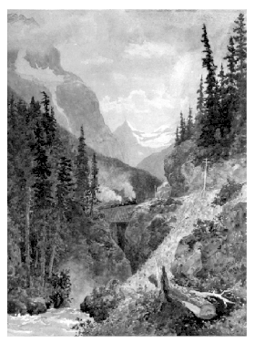 1887 painting | |
| Elevation | 1,627 m (5,338 ft) |
| Traversed by | Trans-Canada Highway; Canadian Pacific Railway |
| Location | Banff National Park, Alberta / Yoho National Park, British Columbia, Canada |
| Range | Canadian Rockies |
| Coordinates | 51°27′09″N 116°17′09″W[1] |
National Historic Site of Canada | |
| Official name | Kicking Horse Pass National Historic Site of Canada |
| Designated | 1971 |

Explorers
First Nations had known and used the pass, but it was first explored by Europeans in 1858 by the Palliser Expedition led by Captain John Palliser. It and the adjacent Kicking Horse River were named after James Hector (Hector's Branch Expeditions, 3 August 1858 – 26 May 1859), was kicked by his horse while attempting rescue of another horse that had gone into the river.
From Hector's summary, which appears on pages 105–106 of Palliser's diary,
Here we met a very large stream, equal in size to Bow River where we crossed it. This river descends the valley from the north-west, and, on entering the wide valley of Beaverfoot River, turns back on its course at a sharp angle, receives that river as a tributary, and flows off to the south-west through the other valley. Just above the angle there is a fall about 40 feet [12 m] in height, where the channel is contracted by perpendicular rocks.
A little way above this fall, one of our pack horses, to escape the fallen timber, plunged into the stream, luckily where it formed an eddy, but the banks were so steep that we had great difficulty in getting him out. In attempting to recatch my own horse, which had strayed off while we were engaged with the one in the water, he kicked me in the chest, but I had luckily got close to him before he struck out, so that I did not get the full force of the blow. However, it knocked me down and rendered me senseless for some time…
31 August.— Every morning just now we have dense fogs, that generally last till nine or ten o'clock, but the evening's are fine and clear. After travelling a mile along the left bank of the river from the N.W., which because of the accident the men had named Kicking Horse River, we crossed to the opposite side.[2]
Railway
A National Historic Site of Canada, the main line of the Canadian Pacific Railway (CPR) was constructed between Lake Louise, Alberta and Field, British Columbia using this route in 1884, in preference to the original survey through the more northerly Yellowhead Pass.[3]
The original section of the CPR between the summit of the pass near Wapta Lake and Field was known as "The Big Hill". With a ruling gradient of 4.5% (1 in 23), it was the steepest stretch of main-line railroad in North America.[4]
Owing to frequent accidents and expensive helper engines associated with railroading in the pass, the CPR built the two Spiral Tunnels that opened in 1909, replacing the direct route. Although they add several kilometres, they reduce the ruling grade to a more manageable 2.2% (1 in 46). Accidents still occur, including a major derailment in 2019 that killed three CPR employees.[5]
Road
The pack train trail over the pass, established at the time of the railway, gradually became a wagon road.[6] In 1928, the Golden–Lake Louise highway, which essentially followed the CPR route, was completed.[7]
This section of the Trans-Canada Highway, built in 1962, follows a more northerly placement along the eastern approach. It reaches its highest point at Kicking Horse Pass at an elevation of 1,643 metres (5,390 ft).[8]
The Golden Triangle cycling route includes the pass.[9]
Television
Dave Broadfoot played The Honourable Member for Kicking Horse Pass in the CBC Television satirical series Royal Canadian Air Farce and in his personal standup routines.
Images
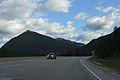 Looking easterly at Kicking Horse Pass from the Trans Canadian Highway
 Panorama of the tunnels from the west, 1908 The Big Hill on the Canadian Pacific Railway


See also
- List of Rocky Mountain passes on the continental divide
References
- "Kicking Horse Pass". BC Geographical Names.
- Palliser, John (1863). Exploration, British North America: The Journals, Detailed Reports and Observations Relative to the Exploration by Captain Palliser of that Portion of British North America Which, in Latitude, Lies Between the British Boundary Line and the Height of Land Or Watershed of the Northern Or Frozen Ocean Respectively And, in Longitude, Between the Western Shore of Lake Superior and the Pacific Ocean, During the Years 1857, 1858, 1859 and 1860. G.E. Eyre and W. Spottiswoode.
- Kicking Horse Pass. Canadian Register of Historic Places. Retrieved 22 January 2012.
- Parkin, Tom W. (1989). "British Columbia Historical News: Twisted Track, North America's Spiral Railroad". www.library.ubc.ca. 22 (3): 17 (15).
- News, CBC (6 February 2019). "Fatal train derailment: A closer look at what happened that tragic day". Canadian Broadcasting Corporation. Retrieved 6 February 2019.
{{cite news}}:|last1=has generic name (help) - Harris, R.C. (1993). "British Columbia Historical News: Early Travelling in the Columbia–Kootenay Valley". www.library.ubc.ca. 26 (4): 10 (8).
- Harvey, R.G. (2006). Carving the Western Path. www.books.google.ca. p. 172. ISBN 9781894974172.
- B.C. Trans-Canada Highway
- "Bicycling the Golden Triangle". Canada Trails. Retrieved 29 December 2017.
External links
- Zoomable map of Kicking Horse Pass showing railway
- Ten Mile Hill Project HD Video
- LibriVox Audiobook Recordings
National Historic Sites of Canada by location | |
|---|---|
| Provinces |
|
| Territories |
|
| Other countries |
|
| |
Protected areas of British Columbia | |||||||||||||||||||||||||||||||||||||||||||||||||||||||||||||||||||||||||
|---|---|---|---|---|---|---|---|---|---|---|---|---|---|---|---|---|---|---|---|---|---|---|---|---|---|---|---|---|---|---|---|---|---|---|---|---|---|---|---|---|---|---|---|---|---|---|---|---|---|---|---|---|---|---|---|---|---|---|---|---|---|---|---|---|---|---|---|---|---|---|---|---|---|
| |||||||||||||||||||||||||||||||||||||||||||||||||||||||||||||||||||||||||
| |||||||||||||||||||||||||||||||||||||||||||||||||||||||||||||||||||||||||
| |||||||||||||||||||||||||||||||||||||||||||||||||||||||||||||||||||||||||
| |||||||||||||||||||||||||||||||||||||||||||||||||||||||||||||||||||||||||
| |||||||||||||||||||||||||||||||||||||||||||||||||||||||||||||||||||||||||
| |||||||||||||||||||||||||||||||||||||||||||||||||||||||||||||||||||||||||
| |||||||||||||||||||||||||||||||||||||||||||||||||||||||||||||||||||||||||
| |||||||||||||||||||||||||||||||||||||||||||||||||||||||||||||||||||||||||
| |||||||||||||||||||||||||||||||||||||||||||||||||||||||||||||||||||||||||
| |||||||||||||||||||||||||||||||||||||||||||||||||||||||||||||||||||||||||
Authority control | |
|---|---|
| General |
|
| National libraries | |
На других языках
- [en] Kicking Horse Pass
[ru] Кикинг-Хорс (перевал)
Перевал Кикинг-Хорс (с англ. — «лягающаяся лошадь») — высокий (1627 м) горный перевал через Континентальный водораздел Америки в Канадских Скалистых горах на границы границе Альберты и Британской Колумбии, и находится в пределах национальных парков Йохо и Банф. Перевал является Национальным Историческим Памятником Канады. Он имеет историческое значение, потому что основная линия Канадской тихоокеанской железной дороги была построена между деревней Лейк-Луиз (Альберта) и городом Филд (Британская Колумбия), используя этот маршрут в 1880-х годах, отклоняясь от изначально запланированного маршрута через перевал Йеллоухед, находящийся севернее[1].Другой контент может иметь иную лицензию. Перед использованием материалов сайта WikiSort.org внимательно изучите правила лицензирования конкретных элементов наполнения сайта.
WikiSort.org - проект по пересортировке и дополнению контента Википедии