geo.wikisort.org - Mountains
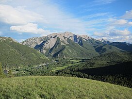
The Livingstone Range is a sub-range of the Canadian Rockies in Alberta, Canada. It forms the eastern boundary of the Rockies in the south of the province. Its northern boundary is the Highwood River, and it extends to the Crowsnest Pass in the south. The Livingstone and Oldman Rivers bound it to the west.
This article relies largely or entirely on a single source. (September 2013) |
| Livingstone Range | |
|---|---|
 NW face of Thunder Mountain | |
| Highest point | |
| Peak | 1,872[1] |
| Elevation | 1,872 m (6,142 ft) |
| Geography | |
| Country | Canada |
| Provinces | Alberta and British Columbia |
| Parent range | Canadian Rockies (Southern Continental Ranges) |
History
The range was named after the explorer David Livingstone by Thomas Blakiston, an assistant of John Palliser, in 1858. When explorer Peter Fidler climbed Thunder Mountain in 1792, he became the first European to make a recorded ascent in the Canadian Rockies.[2]
External links
References
- geographical info
- "Peakfinder". Retrieved 5 July 2011.
Текст в блоке "Читать" взят с сайта "Википедия" и доступен по лицензии Creative Commons Attribution-ShareAlike; в отдельных случаях могут действовать дополнительные условия.
Другой контент может иметь иную лицензию. Перед использованием материалов сайта WikiSort.org внимательно изучите правила лицензирования конкретных элементов наполнения сайта.
Другой контент может иметь иную лицензию. Перед использованием материалов сайта WikiSort.org внимательно изучите правила лицензирования конкретных элементов наполнения сайта.
2019-2025
WikiSort.org - проект по пересортировке и дополнению контента Википедии
WikiSort.org - проект по пересортировке и дополнению контента Википедии