geo.wikisort.org - Mountains
Stanley Peak is a 3,155-metre (10,351 ft) mountain located in the Ball Range, at the northeastern section of Kootenay National Park, in the Canadian Rocky Mountains (British Columbia, Canada).[3][4] The mountain was named in 1901 by its first climber, the English explorer Edward Whymper, after Frederick Stanley, 16th Earl of Derby, the sixth Governor-General of Canada.[3][4] There are sources that date the naming in 1912 after Stanley H. Mitchell, Secretary-Treasurer of Alpine Club of Canada.[1]
| Stanley Peak | |
|---|---|
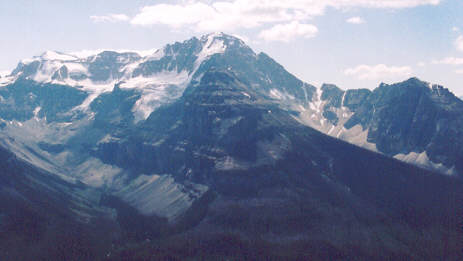 Stanley Peak from Mt. Whymper, 2004 | |
| Highest point | |
| Elevation | 3,155 m (10,351 ft) |
| Prominence | 248 m (814 ft) |
| Listing | Mountains of British Columbia |
| Coordinates | 51°10′14″N 116°03′15″W[1] |
| Geography | |
| Country | Canada |
| Province | British Columbia |
| Protected area | Kootenay National Park |
| Parent range | Ball Range Canadian Rockies |
| Topo map | NTS 82N1 Mount Goodsir |
| Climbing | |
| First ascent | 1901 by Edward Whymper and guides |
| Easiest route | Difficult scramble;[2] UIAA III |

The peak is visible from the Trans-Canada Highway and Highway 93. Stanley Glacier on the northeast face of the peak can be seen up close by following a hiking trail into a hanging valley between the peak and a southern outlier of Storm Mountain.[5]
Stanley Peak can be ascended from a scrambling route by late summer but involves much routefinding among the many ledges and gullies on the north face.[2] Climbing routes (UIAA III) travel the north and northeast faces.
Other BC peaks
There are another two peaks in British Columbia called Stanley Peak. One is 2,935 m high, located at the Squamish-Lillooet Regional District (50°49′48″N 123°43′18″W), 24 km north-west from Keyhole Falls and 62 km west from Gold Bridge.[6] The other is 2,030 m high, in the Stikine Region (59°56′52″N 136°35′35″W) (90 km north-west from Skagway, Alaska United States).[7]
Geology
Stanley Peak is composed of sedimentary rock laid down from the Precambrian to Jurassic periods that was pushed east and over the top of younger rock during the Laramide orogeny.[8]
Climate
Based on the Köppen climate classification, the mountain is located in a subarctic climate with cold, snowy winters, and mild summers.[9] Temperatures can drop below -20 °C with wind chill factors below -30 °C.
See also
- Edward Whymper
- Mount Whymper (Edward)
- Geology of the Rocky Mountains
References
- "Stanley Peak". BC Geographical Names. Retrieved 28 August 2020.
- Kane, Alan (2016). "Stanley Peak". Scrambles in the Canadian Rockies (3rd ed.). Calgary: Rocky Mountain Books. Kindle Edition. ISBN 978-1-77160-098-9.
- "Stanley Peak - British Columbia #1538". Bivouac.com. Retrieved 2 June 2012.
- "Stanley Peak". PeakFinder.com. Retrieved 2 June 2012.
- Patton, Brian; Robinson, Bart (1986). The Canadian Rockies Trail Guide (Third ed.). pp. 280–281. ISBN 0-919934-14-5.
- "Stanley Peak - British Columbia #1801". Bivouac.com. Retrieved 2 June 2012.
- "Stanley Peak - British Columbia #27133". Bivouac.com. Retrieved 2 June 2012.
- Gadd, Ben (2008), Geology of the Rocky Mountains and Columbias
- Peel, M. C.; Finlayson, B. L. & McMahon, T. A. (2007). "Updated world map of the Köppen−Geiger climate classification". Hydrol. Earth Syst. Sci. 11: 1633–1644. ISSN 1027-5606.
На других языках
- [en] Stanley Peak (Ball Range)
[it] Stanley Peak (Ball Range)
Lo Stanley Peak è una montagna alta 3155 metri appartenente alla catena montuosa Ball Range nelle Montagne Rocciose Canadesi e situata nella sezione nord-orientale del Parco nazionale di Kootenay, nella provincia della Columbia Britannica, Canada.[1][2][3]Другой контент может иметь иную лицензию. Перед использованием материалов сайта WikiSort.org внимательно изучите правила лицензирования конкретных элементов наполнения сайта.
WikiSort.org - проект по пересортировке и дополнению контента Википедии