geo.wikisort.org - Reservoir
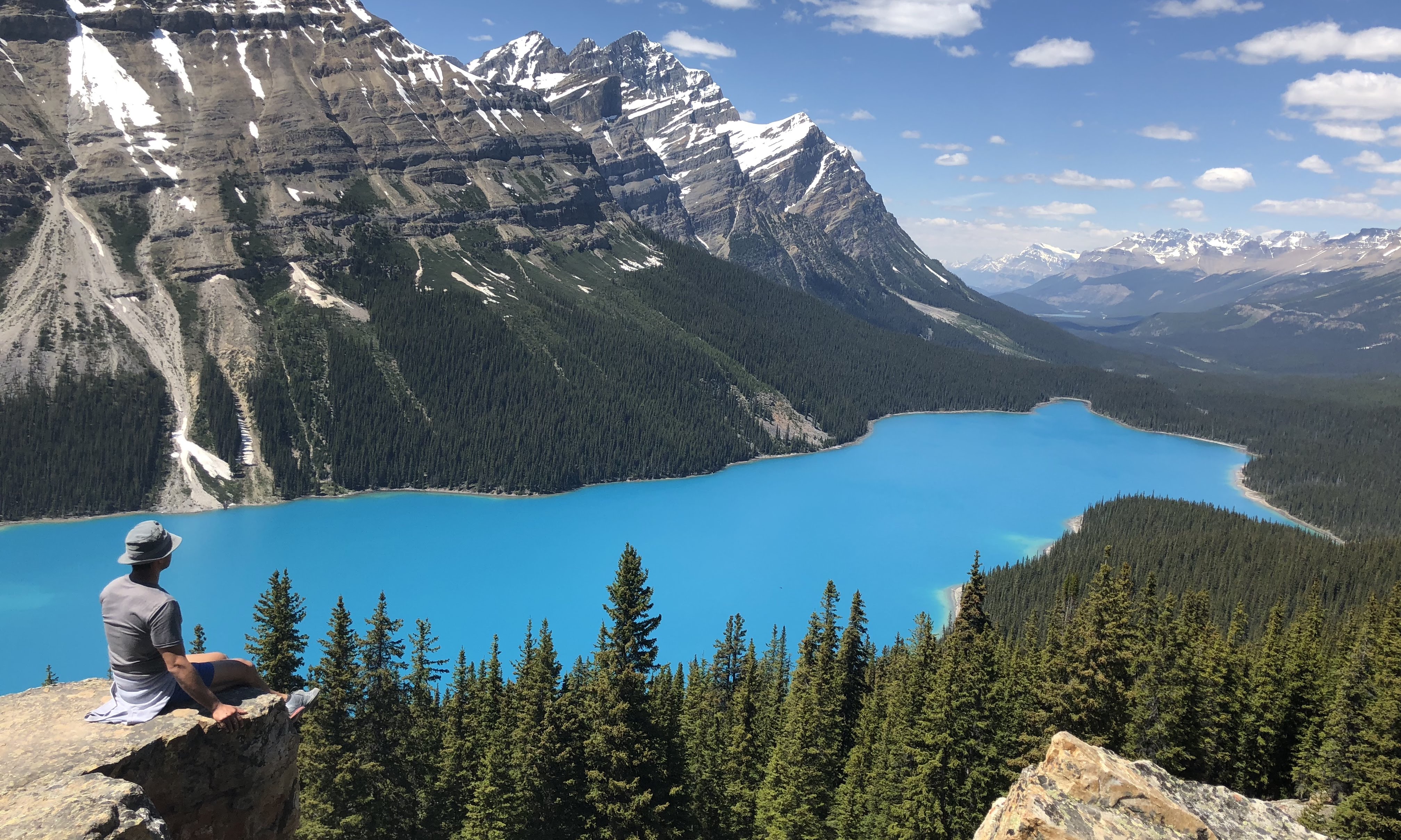
Peyto Lake (/ˈpiːtoʊ/ PEE-toh) is a glacier-fed lake in Banff National Park in the Canadian Rockies. The lake itself is near the Icefields Parkway. It was named for Bill Peyto, an early trail guide and trapper in the Banff area.[1]
| Peyto Lake | |
|---|---|
 | |
 Peyto Lake | |
| Location | Banff National Park, Alberta, Canada |
| Coordinates | 51°43′37″N 116°31′19″W |
| Type | Glacial |
| Primary inflows | Peyto Creek |
| Primary outflows | Mistaya River |
| Basin countries | Canada |
| Max. length | 2.8 km (1.7 mi) |
| Max. width | 0.8 km (0.50 mi) |
| Surface area | 5.3 km2 (2.0 sq mi) |
| Surface elevation | 1,860 m (6,100 ft) |
The lake is formed in a valley of the Waputik Range, between Caldron Peak, Peyto Peak and Mount Jimmy Simpson, at an elevation of 1,860 m (6,100 ft).[2]
During the summer, significant amounts of glacial rock flour flow into the lake from a nearby glacier, and these suspended rock particles are what give the lake a unique bright, turquoise colour. Because of its bright colour, photos of the lake often[when?] appear in illustrated books,[example needed] and the area around the lake is a popular sightseeing spot. In 2021, Parks Canada completed improvements to the lake viewpoint, trails and parking areas.[3] The lake is best seen from Bow Summit, the highest point on the Icefields Parkway.[4]
The lake is fed by Peyto Creek, which drains water from Caldron Lake and Peyto Glacier (part of the Wapta Icefield). Peyto Lake is the origin of the Mistaya River,[5] which heads northwest from the lake's outflow.

References
- "Lake Louise to Bow Summit". canadianrockes.net. Retrieved 2020-11-19.
- W., Boles, Glen (2006). Canadian mountain place names : the Rockies and Columbia Mountains. Laurilla, Roger W., 1959-, Putnam, William Lowell., Putnam, William Lowell. Place names of the Canadian Alps. Calgary, Alta.: Rocky Mountain Books. ISBN 9781894765794. OCLC 244770225.
- "Improvements at Peyto Lake". Parks Canada. Retrieved 7 October 2021.
- Peyto Lake, The Canadian Rockies Archived 2008-04-22 at the Wayback Machine
- MISTAYA CANYON and PEYTO LAKE: Banff National Park, Alberta, Canada: ALONG THE ICEFIELD PARKWAY
External links
 Media related to Peyto Lake at Wikimedia Commons
 Peyto Lake travel guide from Wikivoyage
Hydrography of Alberta | ||
|---|---|---|
| Rivers |  | |
| Waterfalls | ||
| Lakes | ||
| Reservoirs | ||
| Glaciers |
| |
| Other |
| |
This Alberta's Rockies location article is a stub. You can help Wikipedia by expanding it. |
На других языках
[de] Peyto Lake
Der Peyto Lake ist ein Bergsee im Banff National Park in den kanadischen Rocky Mountains. Er kann über den Icefields Parkway erreicht werden. Der See wird von Gletschern gespeist (darunter der gleichnamige Peyto-Gletscher) und ist aufgrund seiner auffälligen türkisen Farbe in vielen Bildbänden über Kanada abgebildet. Diese Wasserfärbung wird durch feine Gesteinspartikel (dem Steinmehl oder Gletschermilch) verursacht, welches auch als rock flour oder glacial flour bezeichnet werden und die mit dem Schmelzwasser in den See gelangen.- [en] Peyto Lake
[es] Lago Peyto
El lago Peyto es un lago de origen glaciar localizado en el parque nacional Banff, uno de los parques nacionales de las Montañas Rocosas canadienses, en la provincia de Alberta, Canadá.[fr] Lac Peyto
Le lac Peyto (Lake Peyto en anglais) est un lac de l'Alberta, situé dans le parc national de Banff et les Rocheuses canadiennes, à environ 40 km au nord de la ville de Banff, facilement accessible par la promenade des Glaciers.[it] Lago Peyto
Il Lago Peyto è un lago glaciale, situato nella parte occidentale dell'Alberta, in Canada. Si trova sulle Montagne Rocciose Canadesi, all'interno del Parco nazionale Banff. Dalle sue acque si origina il fiume Mistaya.[ru] Пейто (озеро)
Пейто (англ. Peyto Lake) — озеро в Национальном парке Банф в Канадских Скалистых горах, Канада. Питается ледниковыми водами.Другой контент может иметь иную лицензию. Перед использованием материалов сайта WikiSort.org внимательно изучите правила лицензирования конкретных элементов наполнения сайта.
WikiSort.org - проект по пересортировке и дополнению контента Википедии