geo.wikisort.org - River
The Slave River is a Canadian river that flows from the confluence of the Rivière des Rochers and Peace River in northeastern Alberta and empties into Great Slave Lake in the Northwest Territories. The river's name is thought to derive from the name for the Slavey group of the Dene First Nations, Deh Gah Got'ine, in the Athabaskan language.[1] The Chipewyan had displaced other native people from this region.
| Slave River | |
|---|---|
 Slave River Watershed | |
| Location | |
| Country | Canada |
| Physical characteristics | |
| Source | |
| • location | Peace-Athabasca Delta |
| • coordinates | 58.99793°N 111.40906°W |
| • elevation | 210 m (690 ft) |
| Mouth | |
• location | Great Slave Lake |
• coordinates | 61.28019°N 113.58798°W |
• elevation | 160 m (520 ft) |
| Length | 434 km (270 mi) |
| Basin size | 616,400 km2 (238,000 sq mi) |
| Discharge | |
| • average | 3,414 m3/s (120,600 cu ft/s) max: 7,930 m3/s (280,000 cu ft/s) min: 543 m3/s (19,200 cu ft/s) (for Fitzgerald, Alberta) |
Rapids and kayaking
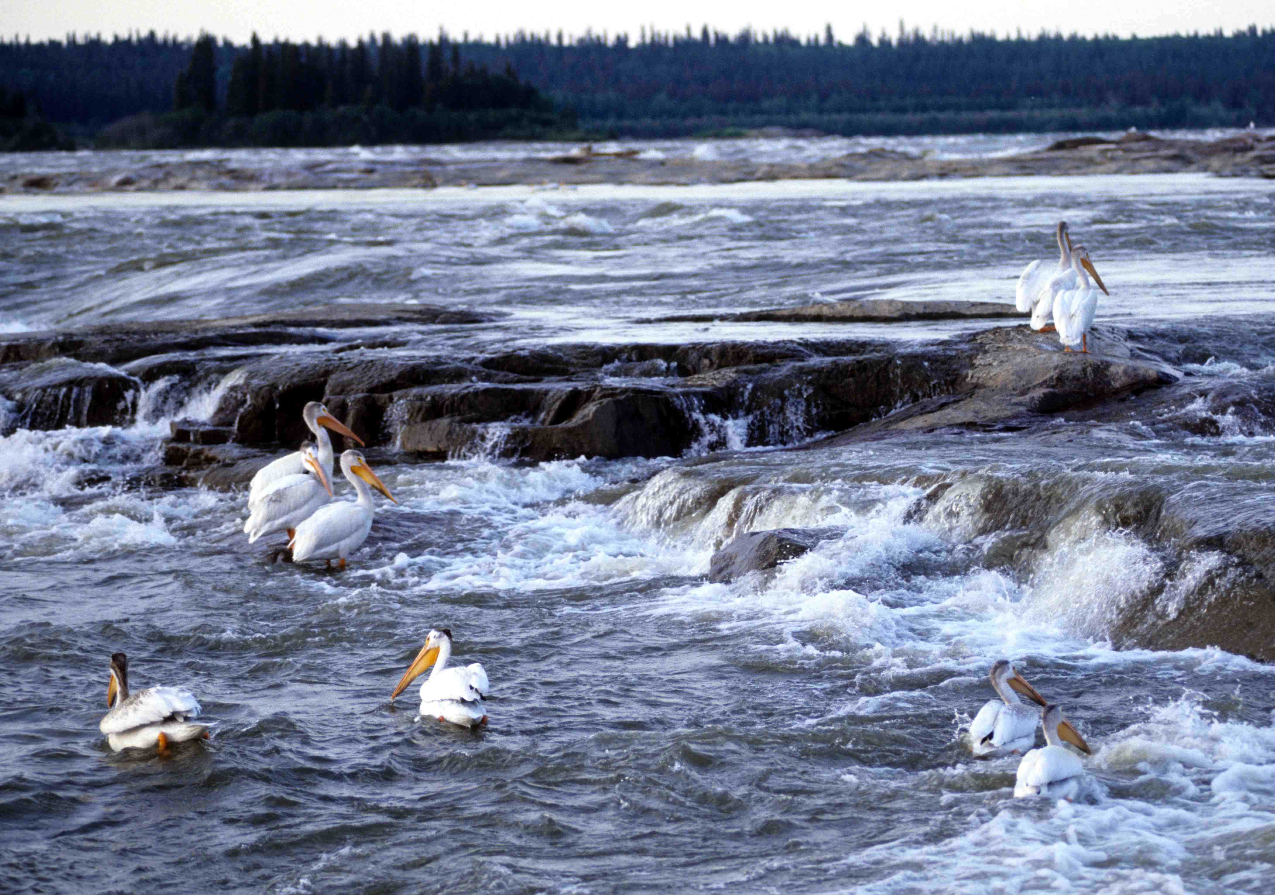

The Slave River and the rapids around Fort Smith are some of the best whitewater kayaking in the world. There are four sets of rapids: Pelican, Rapids of the Drowned, Mountain Portage, and Cassette. The rapids range from easy class I on the International Scale of River Difficulty to unrunnable killer class VI holes. Huge volume, massive waves, and the home of the northernmost river pelican colony in North America characterize this river. The pelicans nest on many of the islands at the Mountain Portage Rapids. These islands serve as a sanctuary to the birds and are closed to human traffic from April 15 to September 15.
Boaters have been killed in the Slave River rapids. The earliest recorded fatalities occurred as a part of Cuthbert Grant's expedition of 1786 at the Rapids of the Drowned (a class II-IV Rapid Set).[2]
Course
The Slave River originates in the Peace-Athabasca Delta, at the forks of Peace River and Rivière des Rochers, which drains the Athabasca River and Lake Athabasca. The Slave River flows north into the Northwest Territories and into the Great Slave Lake north of Fort Resolution. From there the water reaches the Arctic Ocean through the Mackenzie River.
The river is 434 kilometres (270 mi) long and has a cumulative drainage area of 616,400 square kilometres (238,000 sq mi).[3]
Portage and navigation
Prior to the extension of railway service to Hay River, Northwest Territories, a river port on Great Slave Lake, cargo shipment on the Slave River was an important transport route. Locally built wooden vessels were navigating the river into the late 19th century. The rapids required a portage of 26 kilometres (16 mi).[4] Tractors were imported from Germany to assist in hauling goods around the rapids. Tugs and barges of the Northern Transportation Company's "Radium Line" were constructed in the south and disassembled. The parts were then shipped by rail to Waterways, Alberta, shipped by barge to the portage, and portaged to the lower river for reassembly, where they could navigate most of the rest of the extensive Mackenzie River basin.[5]
Tributaries
- Peace-Athabasca Delta
- Athabasca River
- Lake Athabasca
- Rivière des Rochers
- Chilloneys Creek
- Revillon Coupe
- Dempsey Creek
- Peace River
- Scow Channel
- Murdock Creek
- Darough Creek
- Powder Creek
- La Butte Creek
- Hornaday River
- Salt River
- Little Buffalo River
See also
References
- Slave River. (2006). In Encyclopædia Britannica. Retrieved September 12, 2006, from Encyclopædia Britannica Premium Service
- Duckworth, Harry W., ed. (1989). The English River Book: A North West Company Journal and Account Book of 1786. Rupert's Land Record Society. Vol. 1. McGill-Queen's University Press. ISBN 9780773507142. Retrieved 27 Aug 2012. Introduction xxii: "In the fall of 1786 Cuthbert Grant, back from Grand Portage, took a further supply of goods to Great Slave Lake, and on this voyage two canoes, five men, and 'some packages' were lost at the rapids on Slave River still called the Rapids of the Drowned." Introduction xxxvii: "These five - Brisbois, Joseph Derry, Landrieffe, Ledoux, and Scavoyard - may well be the five voyageurs who perished at the Rapids of the Drowned in Slave River, in the fall of 1786, while taking Cuthbert Grant's expedition to Great Slave Lake". This Cuthbert Grant's son is the also-named Cuthbert Grant.
- Atlas of Canada. "Rivers in Canada". Retrieved 2007-05-01.
-
"Early Artifacts To Be Organized". Leader Post. 1971-11-17. p. 50. Retrieved 2012-05-31 – via Google News.
The 12,000 items would go on display in the proposed $300,000 building while larger exhibits such as the early freight ship the Radium King, and ancient German tractors used to portage ships around the dangerous 16 miles of rapids of the Slave River, would be displayed outside.
-
"Radium King en route: Eldorado Subsidiary's Ship Leave for West by Train". Montreal Gazette. 1937-04-15. p. 20. Retrieved 2012-05-31 – via Google News.
Both ships were built for the Northern Transportation Company, a subsidiary of Eldorado Gold Mines, Limited, and will ply the Mackenzie and Athabaska rivers, 1,600 miles north of Edmonton.
External links
- . . 1914.
- . New International Encyclopedia. 1905.
Hydrography of Alberta | ||
|---|---|---|
| Rivers |  | |
| Waterfalls | ||
| Lakes | ||
| Reservoirs | ||
| Glaciers |
| |
| Other |
| |
Authority control | |
|---|---|
| General |
|
| National libraries | |
На других языках
[de] Slave River
Der Fluss Slave (auch „Sklavenfluss“; französisch rivière des Esclaves) ist ein 434 km langer Fluss entlang der östlichen Grenze des Wood-Buffalo-Nationalparks im zentralen bis nordwestlichen Teil Kanadas.- [en] Slave River
[es] Río de los Esclavos
El río de los Esclavos o también río Esclavo (en inglés: 'Slave River'); en francés, Rivière des Esclaves es un río de Canadá que fluye desde el lago Athabasca, al nordeste de la provincia de Alberta, hasta desembocar en el Gran Lago del Esclavo, en los Territorios del Noroeste. El río tiene una longitud de 434 km y drena una gran cuenca de 616.400 km², mayor que países como Ucrania, Botsuana o Madagascar.[it] Fiume degli Schiavi
Il fiume degli Schiavi[1] (Slave River in inglese, Rivière des Esclaves in francese) è un fiume del Canada. Esso scorre a partire dalla confluenza tra i fiumi Rivière des Rochers e Peace in Alberta e che sfocia nel Grande Lago degli Schiavi, nella Provincia dei Territori del Nord-Ovest.[ru] Невольничья
Невольничья (англ. Slave River, фр. rivière des Esclaves) — река в Канаде длиной в 434 км, текущая вдоль восточной границы национального парка Вуд-Баффало в центральной и северо-западной части страны. Вытекает из озера Атабаска в Альберте, течёт в северном направлении через Северо-Западные территории и впадает в Большое Невольничье озеро. Принадлежит к речной системе Маккензи. Бассейн охватывает территорию в 616 400 км².Другой контент может иметь иную лицензию. Перед использованием материалов сайта WikiSort.org внимательно изучите правила лицензирования конкретных элементов наполнения сайта.
WikiSort.org - проект по пересортировке и дополнению контента Википедии