geo.wikisort.org - Island
The island of Lunga is the largest of the Treshnish Isles in Argyll and Bute, Scotland. The Isles are part of the Loch Na Keal National Scenic Area.
| Scottish Gaelic name | Lungaigh |
|---|---|
| Old Norse name | langr-øy |
| Meaning of name | "(long)ship island", from Norse |
| Location | |
 Lunga Lunga shown within Argyll and Bute | |
| OS grid reference | NM278419 |
| Coordinates | 56.49°N 6.42°W |
| Physical geography | |
| Island group | Treshnish Isles |
| Area | 81 ha (3⁄8 sq mi) |
| Area rank | 161 [1] |
| Highest elevation | Cruachan, 103 m (338 ft) |
| Administration | |
| Sovereign state | United Kingdom |
| Country | Scotland |
| Council area | Argyll and Bute |
| Demographics | |
| Population | 0 |
| References | [2][3][4][5][6] |
History
Lunga, which is of volcanic origin, has been described as 'a green jewel in a peacock sea'.[3] It was inhabited until the 19th century, and still bears the remains of blackhouses. The remains of the ruined village, abandoned in 1857, lie in the northeastern part of the island.[7]
Wildlife
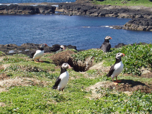

As one of the Treshnish Isles, Lunga is a designated Site of Special Scientific Interest, Special Protection Area and Special Area of Conservation.[8] These designations reflect the importance of the island for its marine life, including the grey seals that inhabit the waters around it, and for its breeding colonies of seabirds, including storm-petrels, kittiwakes, Manx shearwaters, guillemot, puffin, European shag and razorbills. (The birds also breed on the Harp Rock, a sea stack separated from Lunga by a narrow gut.) In addition, barnacle geese winter on the island.[3]
Many rare and endangered plants are also native to Lunga, including primrose, birdsfoot trefoil, orchids, sea campion, sea thrift, sea pinks, yellow flags, tormentil and oyster plant.[3]
In summer, tourist boats visit Lunga from Ulva Ferry, Tiree, Tobermory, Iona and Ardnamurchan. The island's thousands of breeding puffins, who allow visitors to approach to within a few feet of them, are the island's main attraction.
Footnotes
- Area and population ranks: there are c. 300 islands over 20 ha in extent and 93 permanently inhabited islands were listed in the 2011 census.
- 2001 UK Census per List of islands of Scotland
- Haswell-Smith, Hamish (2004). The Scottish Islands. Edinburgh: Canongate. ISBN 978-1-84195-454-7.
- Ordnance Survey
- Iain Mac an Tailleir. "Placenames" (PDF). Pàrlamaid na h-Alba. Archived from the original (PDF) on 26 September 2011. Retrieved 28 July 2007.
- "Regions of Scotland and Gaelic Names" (PDF). Retrieved 1 August 2007.
- "Overview of Lunga". Gazetteer for Scotland. Retrieved 28 July 2007.
- "Treshnish Isles". Wild About Lochaber. Retrieved 22 May 2020.
External links
Inhabited islands of the Hebrides | ||
|---|---|---|
| Inner Hebrides |  | |
| Outer Hebrides | ||
This Argyll and Bute location article is a stub. You can help Wikipedia by expanding it. |
На других языках
- [en] Lunga, Treshnish Isles
[fr] Lunga (îles Treshnish)
Lunga, en gaélique écossais Lungaigh, est une île du Royaume-Uni située dans le sud-ouest de l'Écosse, dans les Hébrides intérieures et faisant partie du council area d'Argyll and Bute. Son nom vient du vieux norrois, et Luing signifiait « rivière des bateaux »[2]. Décrite comme un « joyau vert dans une mer bleu »[3], cette île de 83 hectares fait partie des îles Treshnish qui a été désigné site d'intérêt scientifique particulier pour ses colonies d'oiseaux tels que le macareux moine et le fulmar. Les îles sont également une zone de protection spéciale en raison d'importantes populations d'océanites et de bernaches nonnette[4].[it] Lunga (isola)
L'isola di Lunga è la maggiore delle isole Treshnish, situate in Argyll e Bute, in Scozia.Другой контент может иметь иную лицензию. Перед использованием материалов сайта WikiSort.org внимательно изучите правила лицензирования конкретных элементов наполнения сайта.
WikiSort.org - проект по пересортировке и дополнению контента Википедии