geo.wikisort.org - River
The Shizukuishi River (雫石川, Shizukuishigawa) is a river in Iwate Prefecture, in the Tōhoku region of northern Honshū in Japan. The river is 33.2 kilometres (20.6 mi) long and has a watershed of 168 square kilometres (65 sq mi).
This article does not cite any sources. (August 2010) |
| Shizukuishi River | |
|---|---|
 Shizukuishi River looking northeast from the Morioka Chuo Bridge | |
| Native name | 雫石川 (Japanese) |
| Location | |
| Country | Japan |
| Physical characteristics | |
| Source | |
| • location | Mount Akita-Komagatake |
| • elevation | 1,637 m (5,371 ft) |
| Mouth | |
• location | Kitakami River |
• coordinates | 39°41′40″N 141°08′40″E |
| Length | 33.2 km (20.6 mi) |
| Basin size | 168 km2 (65 sq mi) |
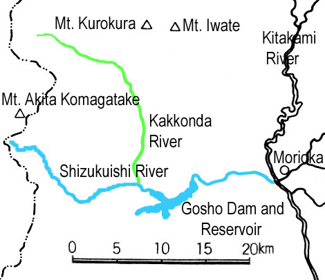
The Shizukuishi River rises in the Ōu Mountains just south of Mount Akita-Komagatake in the town of Shizukuishi and empties into the Kitakami River in the city of Morioka. The Gosho Dam is situated on the Shizukuishi River in western Morioka. This dam was completed in 1981. The entire length of the river is home to many renowned hot springs.
External links
![]() Media related to Shizukuishi River at Wikimedia Commons
Media related to Shizukuishi River at Wikimedia Commons
| |||||||||||||||
| |||||||||||||||
| |||||||||||||||
| |||||||||||||||
| |||||||||||||||
This article related to a river in Japan is a stub. You can help Wikipedia by expanding it. |
This Iwate Prefecture location article is a stub. You can help Wikipedia by expanding it. |
Другой контент может иметь иную лицензию. Перед использованием материалов сайта WikiSort.org внимательно изучите правила лицензирования конкретных элементов наполнения сайта.
WikiSort.org - проект по пересортировке и дополнению контента Википедии