geo.wikisort.org - River
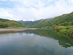
The Shimanto River (四万十川, Shimanto-gawa) is a river in western Kōchi Prefecture, Japan. 196 km in length, it has a watershed of 2,270 km². Its name is written with kanji meaning "forty thousand and ten".
This article does not cite any sources. (April 2010) |
| Shimanto River | |
|---|---|
 The Shimanto River | |
| Native name | 四万十川 (Japanese) |
| Location | |
| Country | Japan |
| Physical characteristics | |
| Mouth | |
• location | 32°56′02″N 132°59′45″E |
| Length | 196 km (122 mi) |
Since the river is remote from major cities and does not have any dams, it is sometimes referred to as "the last clear stream of Japan". Fishing and production of nori[citation needed] is a thriving industry along the river. It has been named one of the "Three Free-Flowing Rivers in Japan", along with the Nagara River in Gifu Prefecture and the Kakita River (柿田川 Kakita-gawa) in Shizuoka Prefecture.
The river also has 47 chinkabashi (沈下橋 lit. 'sinking bridge'), including those of tributaries. Chinkabashi are low water crossings constructed without parapets in order not to be washed away by floods. The prefecture decided to preserve them as cultural heritage.
See also
- Yoshino River, which has similar low water crossings
External links
На других языках
[de] Shimanto (Fluss)
Der Shimanto (jap. 四万十川, Shimanto-gawa, dt.: „Vierzigtausendundzehn-Fluss“) ist mit 196 km der längste Fluss auf der japanischen Insel Shikoku und gilt zugleich als schönster Fluss Japans. Bis 1994 hieß der Fluss amtlich Watarigawa (渡川), was historisch der Name des Unterlaufs war, wurde dann aber auf das üblichere Shimanto geändert.[2]- [en] Shimanto River
[es] Río Shimanto
El Shimanto (四万十川, Shimanto-gawa?) es un río de Japón que atraviesa la zona occidental de la prefectura de Kōchi, en Japón.[it] Shimanto (fiume)
Il fiume Shimanto (四万十川) è un fiume che scorre nella parte occidentale della Prefettura di Kōchi, Giappone. Si sviluppa per 196 km in lunghezza, con un bacino di 2.270 km².[ru] Симанто
Симанто (яп. 四万十川) — река в Японии, самая длинная река на острове Сикоку. Берёт начало в префектуре Коти. Впадает в залив Тоса Филиппинского моря. Одна из немногих рек Японии, которая не имеет на своём русле никаких сооружений, так как течёт по индустриально неразвитой местности.Другой контент может иметь иную лицензию. Перед использованием материалов сайта WikiSort.org внимательно изучите правила лицензирования конкретных элементов наполнения сайта.
WikiSort.org - проект по пересортировке и дополнению контента Википедии