geo.wikisort.org - River
The Isère (US: /iːˈzɛər/ ee-ZAIR,[3][4] French: [izɛʁ] (![]() listen); Arpitan: Isera; Occitan: Isèra) is a river in the Auvergne-Rhône-Alpes region of southeastern France. Its source, a glacier known as the Sources de l'Isère, lies in the Vanoise National Park in the Graian Alps of Savoie, near the ski resort in Val-d'Isère on the border with Italy. An important left-bank tributary of the Rhône, the Isère merges with it a few kilometers north of Valence.
listen); Arpitan: Isera; Occitan: Isèra) is a river in the Auvergne-Rhône-Alpes region of southeastern France. Its source, a glacier known as the Sources de l'Isère, lies in the Vanoise National Park in the Graian Alps of Savoie, near the ski resort in Val-d'Isère on the border with Italy. An important left-bank tributary of the Rhône, the Isère merges with it a few kilometers north of Valence.
| Isère | |
|---|---|
 The Isère in the center of Grenoble | |
 Path of the Isère | |
| Native name |
|
| Location | |
| Country | France |
| Region | Auvergne-Rhône-Alpes |
| Departments |
|
| Physical characteristics | |
| Source | |
| • location | Sources de l'Isère Glacier, Grande Aiguille Rousse, Graian Alps |
| • coordinates | 45°26′45″N 7°5′47″E |
| • elevation | ±2,900 m (9,500 ft) |
| Mouth | |
• location | Rhône |
• coordinates | 44°58′56″N 4°51′8″E |
• elevation | ±110 m (360 ft) |
| Length | 286 km (178 mi)[1] |
| Basin size | 11,890 km2 (4,590 sq mi)[1] |
| Discharge | |
| • average | 329 m3/s (11,600 cu ft/s)[2] |
| Basin features | |
| Progression | Rhône→ Mediterranean Sea |
| Tributaries | |
| • left | Arc, Drac |
| • right | Arly |
| Sources | Sandre, Géoportail, Banque Hydro, Symbhi |
Many riverside communes have incorporated the Isère's name into their own, for example, Sainte-Hélène-sur-Isère and Romans-sur-Isère. The department of Isère is likewise named after the river.
Etymology
The name Isère was first recorded under the form Isara, which means "the impetuous one, the swift one."[5] Not originally a Celtic word, it was very likely assimilated by the Celts in ancient times. This word is related to the Indo-European *isərós, meaning "impetuous, quick, vigorous," which is similar to the Sanskrit isiráḥ इसिरः อิสิระ with the same definition.[6] It was probably based on the reconstructed Indo-European root *eis(ə) (and not *is), which incidentally has not been found in the Celtic languages of the British Isles.[6]
The word Isara figures in the etymology of many other river names, from ancient Gaul and its neighboring lands. Examples of this are the Ésera in Spain, the Isar in Germany, the small Franco-Belgian Yser, or even the ancient name of the Oise, Isara (the French adjective isarien still exists in the language and continues to describe anything related to the Oise). In non-Celtic countries, we find the Isarco, a river in Northern Italy, the Éisra and Istrà in Lithuania,[6],Jizera in the Czech Republic and Usora in Bosnia and Herzegovina.
Geography
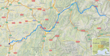
The Isère's course measures 286 kilometers (178 miles)[1] and runs through a wide variety of landscapes: from its source near the Italian border in the western Alps, it crosses the Pays de Savoie and the Tarentaise Valley, cuts between the Chartreuse and Belledonne mountain ranges, follows the Vercors Massif, passes through the Dauphiné province, and finally meets with the Rhône at the foot of the Vivarais.
Valleys

The upper valley of the Isère is called the Tarentaise, and its middle valley the Grésivaudan.
The lower valley constitutes a section of the Plain of Valence (also called the Valentinois)[7] and is characterized by the river's deep, winding channel. Instead of widening its banks over time, the Isère has dug deeper into its bed, forming stepped fluvial terraces. The valley has clearly defined borders and is relatively narrow, not exceeding 2 km (1.2 mi) in breadth.
The repetition of alluvial deposition (during periods of Quaternary glaciation) and overdeepening (during interglacial periods), known as a fluvioglacial system, led to the formation of several stepped terraces in the lower Isère valley, like the one on which Saint-Marcel-lès-Valence is built.[8] This occurred through the massive accumulation of alluvium from the Isère on top of a bed of Miocene molasse. Today, these terraces still define the geography of the Plain of Valence.[9]
Confluence

The Isère initially merges with one of the Rhône's diversion canals, built for navigational purposes, at Pont-de-l'Isère. At the southern tip of La Roche-de-Glun (a commune on an island formed by the canal), the Isère Dam drains part of the water back into the Rhône and permits the Isère to continue its course alone until it passes through the Bourg-lès-Valence Dam and reaches its final junction with the Rhône.
Main Tributaries
(L) Left-bank tributary; (R) Right-bank tributary.
- (L) Doron de Bozel, 38.7 km (24.0 mi)
- (R) Doron de Champagny, 15.9 km (9.9 mi)
- (L) Doron des Allues, 20.9 km (13.0 mi)
- (L) Doron de Belleville, 28.6 km (17.8 mi)
- (R) Arly, 34.5 km (21.4 mi)
- (L) Chaise, 24 km (15 mi)
- (L) Doron de Beaufort, 24.1 km (15.0 mi)
- (L) Arc, 127.5 km (79.2 mi)
- (L) Drac, 130.3 km (81.0 mi)
- (R) Séveraisse, 32.9 km (20.4 mi)
- (L) Souloise, 25.6 km (15.9 mi)
- (R) Bonne, 40.1 km (24.9 mi)
- (L) Ébron, 32.1 km (19.9 mi)
- (R) Romanche, 78.4 km (48.7 mi)
- (L) Gresse, 34.6 km (21.5 mi)
- (R) Vence, 17.2 km (10.7 mi)
- (R) Morge, 27.2 km (16.9 mi)
- Fure, 25.3 km (15.7 mi), via the Morge Canal
- (L) Bourne, 43.1 km (26.8 mi)
- (L) Vernaison, 32 km (20 mi)
- (R) Herbasse, 40 km (25 mi)
Cities on the Isère
- Savoie: Val-d'Isère, Bourg-Saint-Maurice, Aime, Moûtiers, Albertville, Montmélian
- Isère: Pontcharra, Grenoble, Voreppe
- Drôme: Romans-sur-Isère, Pont-de-l'Isère, La Roche-de-Glun
Hydrology

The length of the Isère is 286 km (178 mi), and its drainage basin covers 11,890 km2 (4,590 sq mi).[1]
The vertical profile of the river is made up of several zones:[10]
- From its sources to Sainte-Foy-Tarentaise (except for those sources having a slope of around 25%),[11] the average slope of the Isère is 5.1%, in a more or less confined valley (forests, gorges, and higher up, grasslands).
- As far as Moûtiers, the slope measures 1.18%.
- Before the river's confluence with the Arly, its slope is only 0.53%.
- The slope decreases to 0.136% until Grenoble.
- Downstream from Grenoble, it measures 0.1%.
The flow of the Isère was observed over a period of 58 years (between 1956 and 2015) at Beaumont-Monteux in the Drôme department, situated near the river's confluence with the Rhône. The discharge of the river at Beaumont-Monteux measured 329 cubic meters per second (11,600 cubic feet per second).[2]
The Isère's large seasonal fluctuations are typical of rivers fed in large part by snowmelt, with springtime flooding raising the average monthly discharge between 382 (13,500) and 500 m3/s (18,000 cu ft/s) from April to July (peaking in May and June), and low water levels in autumn and winter, from August to February, with a minimum average monthly discharge of 246 m3/s (8,700 cu ft/s) in September.[2] Generally speaking, this makes the Isère a very plentiful watercourse throughout the year.

However, the VCN3[12] can drop to 110 m3/s (3,900 cu ft/s) during a five-year dry spell,[2] which is very low.
On the other hand, severe flooding can result from rapid thaw or torrential autumn rain. In fact, QIX 2[13] and QIX 5 are 1,200 (42,000) and 1,500 m3/s (53,000 cu ft/s), respectively. QIX 10 is 1,700 m3/s (60,000 cu ft/s). QIX 20 reaches 1,900 m3/s (67,000 cu ft/s), while QIX 50 rises to 2,200 m3/s (78,000 cu ft/s),[2] which is still moderate compared to other rivers in the south of France, like the Tarn.
The highest instantaneous discharge on record was 2,050 m3/s (72,000 cu ft/s) on September 16, 1960, while the highest daily value was 1,510 m3/s (53,000 cu ft/s) on October 7 of the same year.[2]
The depth of runoff for the Isère's drainage basin is 882 millimeters (34.7 inches) annually, which is quite high above France's average and clearly superior to that of the Rhône's drainage basin (666 mm (26.2 in) in Valence for a surface area of 66,450 km2 (25,660 sq mi)[14]). The specific discharge[15] is 27.9 liters per second per square kilometer of drainage basin.[2]

Gallery
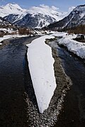 The Isère from La Daille, near Val-d'Isère
 Moûtiers: the Isère and the cathedral
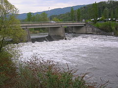 The bridge on the Isère at Montmélian
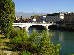 The Isère leaving Grenoble
 The Isère at Romans-sur-Isère
![Antoine Guindrand Paysage de l'Isère [Isère landscape] (1836)](//upload.wikimedia.org/wikipedia/commons/thumb/6/63/Antoine_Guindrand_-_Paysage_de_l%27Is%C3%A8re_-_1836.JPG/241px-Antoine_Guindrand_-_Paysage_de_l%27Is%C3%A8re_-_1836.JPG) Antoine Guindrand
Antoine Guindrand
Paysage de l'Isère [Isère landscape] (1836)


![Antoine Guindrand Paysage de l'Isère [Isère landscape] (1836)](http://upload.wikimedia.org/wikipedia/commons/6/63/Antoine_Guindrand_-_Paysage_de_l%27Is%C3%A8re_-_1836.JPG)
See also
References
- Sandre. "Fiche cours d'eau - Isère (W---0000)". Retrieved 24 March 2015.
- "Synthèse : L'Isère à Beaumont-Monteux". Banque Hydro (in French). Eaufrance. Retrieved 25 March 2015.
- "Isère". The American Heritage Dictionary of the English Language (5th ed.). HarperCollins. Retrieved 22 August 2019.
- "Isère". Merriam-Webster Dictionary. Retrieved 22 August 2019.
- "ISARA / ISAROS (ISÈRE)". Encyclopédie de l'Arbre Celtique (in French). Guillaume Roussel. 2009. Retrieved 24 March 2015.
- Delamarre, Xavier (2003). Dictionnaire de la langue gauloise : une approche linguistique du vieux-celtique continental [Dictionary of the Gallic Language: A Linguistic Approach to Continental Old Celtic]. Collection des Hespérides (in French) (Revised and augmented 2nd ed.). Paris: Errance. p. 191. ISBN 978-2-87772-369-5. OCLC 354152038.
- Ravit, Philippe (2007). Le paysage valentinois, de la fondation de la colonie de Valentia (Valence) au IIIème siècle ap. J.-C. (Dissertation) (in French). Université Jean Moulin Lyon 3. p. 202.
- Delahaye, Emmanuelle (23 January 2009). "Chapter 2.1.2., page 'Caractéristiques topographiques : au-dessus du fleuve'". Les espaces fluvio-urbains rhodaniens à l'aval de Lyon, Vienne, Valence, Avignon, Tarascon, Beaucaire et Arles : des territoires à la dérive ? [Urban river spaces along the Rhône downstream of Lyon, Vienne, Valence, Avignon, Tarascon, Beaucaire and Arles: territories left to drift?] (Thesis) (in French). Université Lumière Lyon 2. Retrieved 25 March 2015.
- Faucher, Daniel (1914). "La plaine de Valence (Bas-Dauphiné)" [The Plain of Valence (Lower Dauphiné)]. Annales de Géographie (in French). Armand Colin. 23 (128): 127–128. doi:10.3406/geo.1914.8134. ISSN 0003-4010. Retrieved 20 March 2015 – via Persée.
- Géoportail Maps
- The starting point is at 2,341 m, near the Prariond Refuge. The ending point is situated just downstream of Villaroger.
- VCN3 is an acronym used by French hydrologists to represent the mean flow of a river recorded over three consecutive days in order to characterize the severity of a drought. Eaufrance Glossary on Water - Minimum Annual Mean Flow
- QIX is an acronym used by French hydrologists to represent the likely return interval of a flood with a given severity. For example, QIX 2 = once in two years, while QIX 10 = once in 10 years. Eaufrance Glossary on Water - Flood Flow
- "Le Rhône à Valence" [The Rhône at Valence]. Banque Hydro (in French). Eaufrance. 8 March 2015. Archived from the original (PDF) on 2 April 2015. Retrieved 25 March 2015.
- Eaufrance Glossary on Water - Specific Flow
External links
- Coolidge, William Augustus Brevoort (1911). . Encyclopædia Britannica. Vol. 14 (11th ed.). p. 867.
Authority control | |
|---|---|
| General | |
| National libraries | |
| Other |
|
На других языках
[de] Isère
Die Isère (Isara in der Antike, früher italienisch Isera) ist ein Fluss in Frankreich, der in der Region Auvergne-Rhône-Alpes verläuft. Sie entspringt in den Savoyer Alpen nahe der Grenze zu Italien, im Nationalpark Vanoise. Das Quellgebiet bildet der nach dem Fluss benannte Gletscher Glacier des Sources de l’Isère, der sich an der Nordflanke der Grande Aiguille Rousse erstreckt. Die eigentliche Quelle liegt beim Col de la Vache im Gemeindegebiet von Val-d’Isère. Der Fluss entwässert trotz größerer Richtungsänderungen generell in südwestlicher Richtung und mündet nach rund 286[2] Kilometern unterhalb von Pont-de-l’Isère, nördlich von Valence, als linker Nebenfluss in die Rhône. Die Isère durchquert auf ihrem Weg die Départements Savoie, Isère (für das sie Namensgeber ist) und Drôme.- [en] Isère (river)
[es] Río Isère
El Isère ( pronunciado [i.zɛʁ] ) es un río del sureste de Francia. Afluente importante de la rivera izquierda del Ródano, nace en el macizo de los Alpes, en Saboya, en el parque nacional de la Vanoise, en la comuna de Val d'Isère, en el glaciar de los manantiales del Isère, a los pies de la Grande Aiguille Rousse. Fluye hacia el Ródano, a pocos kilómetros al norte de Valence.[it] Isère (fiume)
L'Isère (in italiano Isero[2][3][4], desueto) è un fiume della Francia sud-orientale, che trae origine dalle Alpi Graie. Misura 290 km[1] dalla sua sorgente posta nei pressi del Colle dell'Iseran fino a Valence, dove confluisce nel Rodano.[ru] Изер (приток Роны)
Изе́р (фр. Isère), река на юго-востоке Франции, левый приток Роны. Длина 290 км, площадь бассейна 11,8 тыс. км². Средний расход воды — 330 м³/с.[1]Другой контент может иметь иную лицензию. Перед использованием материалов сайта WikiSort.org внимательно изучите правила лицензирования конкретных элементов наполнения сайта.
WikiSort.org - проект по пересортировке и дополнению контента Википедии