geo.wikisort.org - Mountains
The Vercors Massif is a range in France consisting of rugged plateaux and mountains straddling the départements of Isère and Drôme in the French Prealps. It lies west of the Dauphiné Alps, from which it is separated by the rivers Drac and Isère. The cliffs at the massif's eastern limit face the city of Grenoble.
This article needs additional citations for verification. (July 2014) |
| Vercors | |
|---|---|
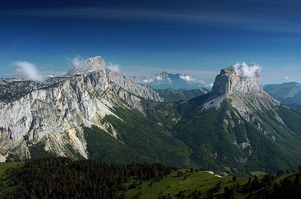
 The view to the north of Le Grand Veymont | |
| Highest point | |
| Peak | Grand Veymont |
| Elevation | 2,341 m (7,680 ft) |
| Coordinates | 44°52′12″N 5°31′37″E |
| Dimensions | |
| Length | 60 km (37 mi) North |
| Width | 40 km (25 mi) West |
| Area | 1,350 km2 (520 sq mi) |
| Geography | |
 | |
| Country | France |
| Region | Rhône-Alpes |
| Range coordinates | 44°58′N 5°25′E |
| Parent range | Alps |

Background
Over time, various features of the complex geography have been recognised including, the Quatre Montagnes (four mountains), the Coulmes (gorges), the Vercors Drômois (Drome Vercors), the Hauts-Plateaux (high plateau) and, in the foothills, Royans, Gervanne, Diois, and Trièves.
The massif is sometimes called the fortress. The movement of people tends to be between the massif and the surrounding plains rather than between the various parts of the massif itself.
Until the mid twentieth century, the name, Vercors was used to describe only the township of La Chapelle-en-Vercors (with Royans), and the northern area around Lans-en-Vercors, Villard-de-Lans, Autrans, and Méaudre (with Grenoble) and was known as the Four Mountains area.
In June and July 1944, the massif became important in World War II with the establishment of the Free Republic of Vercors, led by the Maquis du Vercors, a base for the French Resistance against German occupation.
The Vercors includes the largest alpine karst area in the Northern French pre-alps, and contains a number of large and deep cave systems.[1] These include Gouffre Berger, which is over 1,100 metres (3,600 ft) deep,[2] and the Réseau de Coufin-Chevaline (grotte de Choranche), a show cave in the Bourne Gorge which has almost 30 kilometres (19 miles) of mapped passages.[3]
The Vercors has several resorts for cross-country skiing and for down-hill skiing. Villard-de-Lans is the biggest down-hill ski resort.
This sporting area is environmentally protected, and although the natural environment has been drastically altered throughout history for the purposes of agriculture and forestry, plans for afforestation will make it one of the major forests of Metropolitan France and a reserve for species such as the southern tulip and black grouse, two symbols of the park, as well as the re-introduced griffon vulture and the alpine ibex. The differences in climate and altitude across the Vercors are reflected in the high level of diversity in the fauna and flora.
Etymology
The name Massif du Vercors is derived from the name of a local tribe who lived in the area at the time of the Roman conquest of Gaul, who were known as the Vertamocorii (also spelled Vertamocori, Vertacomicorii, or Vertacomocorii), meaning excellent troops or troops of the summit. Modern inhabitants are referred to as Vertacomiriens.
Prior to the 1900s, the name Vercors referred to the upper valleys of the Vernaison near the township of La Chapelle-en-Vercors. At the beginning of the 20th century, Henri Ferrand explored the massif, taking numerous photographs, publishing books, and describing the geology of the mountains. Ferrand was the first to use the term Vercors in its contemporary sense. The geographers Raoul Blanchard and Jules Blache, popularised the term in the late 1920s and early 1930s. By the 1950s, the term was ubiquitous.
Geography
Location
The Vercors Massif lies in the Prealps, in the south-east France, straddling the departments of Drôme and Isère, both of which are part of the Rhône-Alpes region, about 100 kilometres (62 mi) south-east of Lyon. The massif covers 135,000 hectares (520 sq mi) with a north-south length of 60 kilometres (37 mi) and an east-west width of 40 kilometres (25 mi).
The massif is surrounded by the Chartreuse Mountains to the north, the Matheysine area of the Dauphiné Alps to the east, and the Diois Massif to the south. In the far south-east, the massif joins with the 1,457 metres (4,780 ft) col de Menée.
The massif is drained in the north-east and the north-west by the Isère, in the east by the Drac, and in the south by the Drôme. The western side overlooks the Rhône Valley.
Topography
Geomorphology

The Vercors Massif is known as the fortress or as the French dolomites because of its geomorphology. The massif is likened to a plateau: the fall from the massif to its inner valleys is a few hundred metres, while the fall to the surrounding areas is between 800 metres (2,600 ft) and 1,200 metres (3,900 ft).
The crest of the eastern edge has several summits over 2,000 metres (6,600 ft). The interior varies between 800 metres (2,600 ft) and 1,500 metres (4,900 ft). The massif also has wide valleys including the valley of Lans-en-Vercors, the regions around Autrans, and La Chapelle-en-Vercors, and plateaus including forêt des Coulmes, forêt de Lente, and the high plateau. There are a number of deeply incised gorges, including the Bourne and Furon Gorges. These have imposing cliffs often exceeding 400 metres (1,300 ft) such as the Combe Laval and the Cirque d'Archiane.
Mont Aiguille stands apart from the rest of the massif as the result of erosion. Other parts are isolated from the rest of the massif due to its relief. For example, to reach Gresse-en-Vercors in the south, one must travel 100 kilometres (62 mi) via the col de Rousset or journey 70 kilometres (43 mi) via Saint-Nizier-du-Moucherotte in the north. The villages at the far northern end were isolated by a landslide near the Mortier tunnel. Another example is the Peuil plateau in the east. During the Ice Age, the Grésivaudan glacier reached the Peuil plateau leaving a marsh.
Sub-divisions

The central part of the Vercors Massif is divided into several regions.[4]
The Coulmes, in the north-west, are heavily covered in forest. Folds of Urgonian limestone are rounded, making the area appear mountainous.
The four mountains area has been developed for tourism and skiing but is also known for its traditional activities such as the breeding of dairy cows and cheese making. The main villages, Autrans, Méaudre, Lans-en-Vercors, and Villard-de-Lans, are spread over two plateaux covered by wooded hills.
The Drômois Vercors is an area made up of a number of smaller plateaux. In the north of the Drômois Vercors there are several gorges which are traversed by roads cut into the cliffs. Grassy areas are used as pastures in the summer months, and the biannual migration (transhumance) of animals is a period of celebration for the people of Die.
The Haut-Plateaux (high plateaux) are the highest wilderness areas of the massif. The area is managed and the pastures are used for grazing in the summer.
At the fringes of the massif, the Vercors regional park has four geographical areas. The Royans, the north-west foothills are the location of walnuts growing. Three valleys descend to the edge of the Royans: the Gorges de la Bourne, the cirque of the Combe Laval, and the Échevis valley, including the Grands and the Petits Goulets.
The Gervanne, in the south-west, is a rugged area of hills at the foot of the plateau, with picturesque villages. It looks towards Crest.
The Diois is a part of the Drôme valley around Die. This region has a Mediterranean character, with vineyards and fields of lavender. It acts as a buffer between Gervanne and the interior of the massif.
The Trièves, in the east, is a low hilly plateau, which lies between the highest summits of the Vercors and the gorge carved out by the Drac.

Principal summits
From north to south:
- Le Moucherotte, 1,901 m, the summit which dominates Grenoble, most northerly of the massif
- Le Pic Saint-Michel, 1,966 m
- Roc Cornafion, 2,049 m
- Les Arêtes du Gerbier, 2,109 m
- La Grande Moucherolle, 2,284 m
- La Petite Moucherolle, 2,156 m
- La Tête des Chaudières, 2,029 m
- Les Rochers de la Balme, 2,063 m
- Le Sommet de Malaval, 2,097 m
- Le Grand Veymont, 2,341 m, highest point of the massif
- Le Mont Aiguille, 2,086 m, with its characteristic silhouette, its first ascent in 1492 was the birth of alpinism
- Le Dôme ou Pié Ferré, 2,041 m, to the east of Die, in the Glandasse uplands.
Principal road cols
By descending altitude:
- Col du Mont Noir, 1,421 m, between Malleval-en-Vercors and Rencurel
- Col de l'Allimas, 1,352 m, between Gresse-en-Vercors and Saint-Michel-les-Portes
- Col de la Chau, 1,337 m, between Vassieux-en-Vercors and Bouvante
- Col de la Bataille, 1,313 m, between Léoncel and Bouvante
- Col de Rousset, 1,254 m (tunnel altitude), between Die and Saint-Agnan-en-Vercors
- Col de Saint-Alexis, 1,222 m, between Vassieux-en-Vercors and Saint-Agnan-en-Vercors
- Col de la Croix-Perrin, 1,218 m, between Lans-en-Vercors and Autrans - Méaudre
- Col de Carri, 1,202 m, between La Chapelle-en-Vercors and Bouvante
- Col de la Portette, 1,175 m, in Bouvante
- Col de l'Arzelier, 1,154 m, between Château-Bernard and Le Gua
- Col de Tourniol, 1,145 m, between Léoncel and Barbières
- Col de Proncel, 1,100 m, between Vassieux-en-Vercors and La Chapelle-en-Vercors
- Col des Limouches, 1,086 m, between Léoncel and Peyrus
- Col de Romeyère, 1,069 m, between Rencurel and Saint-Gervais
- Col de la Machine, 1,011 m, between Saint-Jean-en-Royans and Bouvante.
The Tunnel du Mortier links Montaud with Autrans, at an altitude of 1,391 metres (4,564 ft). It was closed on 20 April 1992 after a landslide of 20,000 m3 of rock which involved part of the slope to the north of the route. The instability of the slopes have proved an impediment for the realisation of further work below the site, particularly work on the gorges d'Engins to Sassenage road, the D531.
Principal caves

The commune in which the cave is situated is given in italics.
- Réseau du Gouffre Berger, d'Engins en Isère, 31,790 metres (104,300 ft) long, 1,271 metres (4,170 ft) deep.
- Réseau du Trou qui souffle
, Autrans-Méaudre en Vercors, 42,900 metres (140,700 ft) long, 670 metres (2,200 ft) deep.[3] - Réseau du Clot d'Aspres
, Villard-de-Lans, 42,000 metres (138,000 ft) long, 1,066 metres (3,497 ft) deep.[3] - Réseau de Coufin-Chevaline
, Choranche, 29,839 metres (97,897 ft) long, 411 metres (1,348 ft) deep.[3] - Grotte de Gournier
, Choranche, 18,000 metres (59,000 ft) long, 680 metres (2,230 ft) deep.[3] - Antre des Damnés
, Corrençon-en-Vercors, 5,000 metres (16,000 ft) long, 865 metres (2,838 ft) deep.[2] - Grotte de la Luire
, Saint-Agnan-en-Vercors, 37,563 metres (123,238 ft) long, 547 metres (1,795 ft) deep.[3] - Réseau des Chuats, Bouvante, 42,000 metres (138,000 ft) long.[3]
The Grotte de Bournillon, located in the commune of Châtelus, has the highest cave opening in Europe (418 meters).
Climate
The climate of the Vercors due to its elevation is much more rigorous than the lowlands surrounding the massif. The village of La-Chapelle-en-Vercors, approximately in the center of the massif, has a Dfb climate under the Köppen Classification system. Winters are cold; summers are warm; and precipitation, often snow in the winter, is abundant in all seasons.
Geology
The constituent rocks of the Vercors were formed by sedimentation about 165 million years ago, in the middle Jurassic period, at the bottom of the Piemont-Liguria Ocean. The deposition of animal material formed limestone, with detritus rocks, formed primarily from the erosion of marl from the Variscan orogeny formed the massif in a period marked by changing climatic conditions and ocean depth. At Diois and Trièves is a layer of the massif, formed in the Tithonian age. Then, about 130 million years ago, in the Cretaceous period, a rise in temperatures combined with shallow waters led to the development of coral reefs, which abounded with molluscs, particularly rudists. These were the origin of the Urgonian Limestone which forms the upper part of the massif, more prominently in the northern half. This primitive fauna left numerous fossils, some of which have been found at a site near Rencurel in the Coulmes.
In the Paleogene period, the Tethys ocean closed up and at the start of the Miocene, the raising of the Alps involved the thrusting of a nappe to the west. Sedimentary rocks were raised 2,000 metres (6,600 ft) above the current location of the Massif des Écrins and faulted and folded in the process.
Subsequent marine transgressions were responsible for secondary sedimentation in the basins. There was widening of the gorges and erosion of the cliffs from runoff, leading to the formation of the molasse in the Royans and also in the valleys of Lans, Autrans, and Rencurel. At the close of the Miocene, a new period of uplifting brought about the final receding of the sea.
Once formed, the massif underwent severe erosion, which accentuated the relief. The different synclines grew larger, eventually forming valleys including those of Autrans, Méaudre and Lans, Villard, Corrençon, the Col de Romeyère and the Col de Rousset. The water hollowed out the cirque of Archiane, the steephead valley of Bournillon, and the Combe Laval.
Vercors in popular culture
The Vercors have appeared in many films, including;
- La Bride sur le cou (1961)
- Wish Me Luck (1987) Season 3
- Une hirondelle a fait le printemps (2001)
- The Butterfly (2002)
- To Paint or Make Love (2006)
See also
- Battle of Vercors
References
- Gunn, John, ed. (2004). Encyclopedia of Caves and Karst Science. New York: Fitzroy Dearborn. p. 1610.
- Gulden, Bob. "World's Deepest Caves". Retrieved 11 February 2021.
- Gulden, Bob. "World's Longest Caves". Retrieved 11 February 2021.
- Les régions, Parc naturel régional du Vercors
Sources
Jean-Jacques, Delannoy (1984). "Le Vercors : un massif de la moyenne montagne alpine". Karstologia. Fédération Française de Spéléologie et de l'Association Française de Karstologie: 34–45. ISSN 0751-7688. (in French).
Authority control | |
|---|---|
| National libraries | |
| Other |
|
На других языках
[de] Vercors
Der Vercors ist ein durch tiefe Täler begrenzter Gebirgsstock im äußersten Westen der französischen Alpen. Er hat eine Ausdehnung von etwa 30 mal 40 Kilometer und mehrere Zweitausender (Gipfelhöhen bis zu 2350 m). Da er an allen Seiten schroff ansteigt, konnte er erst im 20. Jahrhundert, teilweise mit in den Fels gesprengten Galerien, für den Straßenverkehr zugänglich gemacht werden. Aufgrund der eingeschränkten Nutzbarkeit befindet sich im Vercors das mit 170 Quadratkilometern größte Naturschutzgebiet Frankreichs.- [en] Vercors Massif
[fr] Massif du Vercors
Le massif du Vercors est un massif montagneux des Préalpes, à cheval sur les départements français de l'Isère et de la Drôme, culminant à 2 341 mètres d'altitude au Grand Veymont, et constituant une région naturelle. Sa nature géologique principalement calcaire se caractérise par un relief constitué de falaises, de crêtes, de vaux, de gorges, plus complexe que le qualificatif de « plateau » pourrait le laisser supposer. De ce fait, il est divisé en plusieurs régions, géographiquement et historiquement distinctes : les Quatre Montagnes, les Coulmes, le Vercors drômois, les Hauts-Plateaux et, en piémont, le Royans, la Gervanne, le Diois et le Trièves. Le surnom de « Forteresse » lui est par ailleurs associé.[it] Prealpi del Vercors
Le Prealpi del Vercors (dette anche Massiccio del Vercors) sono un gruppo montuoso francese delle Prealpi del Delfinato. Situate nei dipartimenti dell'Isère e della Drôme, si trovano a ovest delle Alpi del Delfinato, da cui sono separate dai fiumi Drac e Isère. La vetta più alta è il Grand Veymont che raggiunge i 2.346 m s.l.m.. Al loro margine orientale si trova la città di Grenoble. Comprende varie stazioni sciistiche, di cui la maggiore è Villard-de-Lans.[ru] Веркор (горный массив)
Веркор (фр. Massif du Vercors) — горный массив во Французских Предальпах.Другой контент может иметь иную лицензию. Перед использованием материалов сайта WikiSort.org внимательно изучите правила лицензирования конкретных элементов наполнения сайта.
WikiSort.org - проект по пересортировке и дополнению контента Википедии