geo.wikisort.org - Mountains
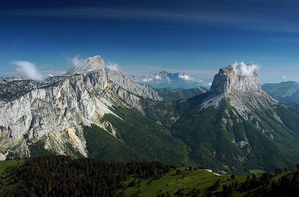
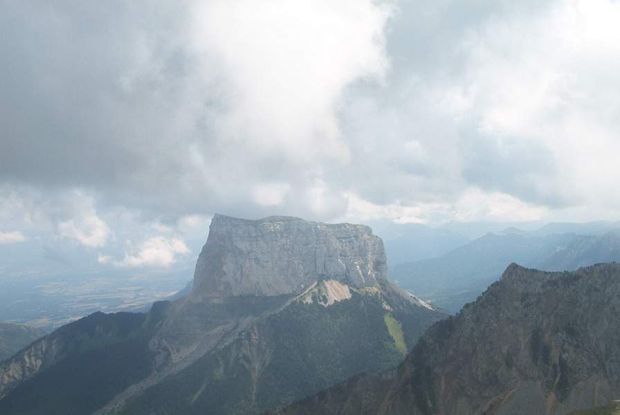
Mont Aiguille (2,085 m (6,841 ft)) is a mountain in the Vercors Massif of the French Prealps, located 58 km (36 mi) south of Grenoble, in the commune of Chichilianne, and the département of Isère. The mountain, known as one of the Seven Wonders of Dauphiné, is a relatively flat limestone mesa surrounded by steep cliffs. The mountain lies within an area designated in 1970 as the Vercors Regional Natural Park. Mont Aiguille's limestone cliffs, especially on the northwest side, are popular with climbers. Its first climb in 1492 was said to mark the birth of mountaineering.
| Mont Aiguille | |
|---|---|
 Mont Aiguille (right) | |
| Highest point | |
| Elevation | 2,085 m (6,841 ft) |
| Prominence | 451[1] |
| Coordinates | 44°50′31″N 05°33′09″E |
| Geography | |
 Mont Aiguille France  Mont Aiguille Alps | |
| Location | Isère, Rhône-Alpes, France |
| Parent range | Vercors Massif |
| Climbing | |
| First ascent | 1492 by Antoine de Ville |
| Easiest route | Basic rock climb |
Topography and geography
Mont Aiguille is a mesa eroded from the Vercors Plateau in the drainage basin of the Rhône. It is surrounded by steep cliffs and has a height of 2,085 metres (6,841 ft) and a clean prominence of 465 m (1,526 ft).[2][3] The surrounding terrain is difficult enough to warrant a technical climb as the easiest method of ascent.[2] The mountain is capped with meadows botanically similar to those on the Vercors High Plateau, but beneath the cliffs there are extensive forests.[4] The mountain lies within the Vercors Regional Natural Park and is in the département of Isère. The nearest access by rail is in the village of Saint-Martin-de-Clelles and by road is from the north via the Col de La Bâtie.[3]
Geomorphology and geology
Geomorphologically, the mountain is a mesa-like outlier, that is to say, the remains of a plateau that has been otherwise eroded to leave only a single pillar of rock - weaker or fractured rocks (the so-called Jasneuf fault)[5] between the current summit and the Vercors high plateau were eroded over time by over 400 metres, leaving the peak standing on its own.[6] This has resulted in several unique features of Mont Aiguille, including the cliffs, which are almost identical to those on the eastern edge of the Vercors Plateau such as those on the edge of the Grand Veymont, which is the highest point of the range.[5][6] Another feature resulting from this is the presence of meadows on the summit plateau, which are similar to those to the west on the rest of the Vercors plateau.[5]
Mont Aiguille is a limestone mesa, previously connected to the main body of the high plateau of the Vercors Massif.[5][6] The summit is made up of lower Barremian strata, deposited during the Cretaceous period.[5][7] This is the same as the plateau to the west, but not as the immediate environs: the lower slopes are composed of older Hauterivian strata.[7] As easily observed, the bedding planes are all roughly level, although there is some inclination down to the north-east.[7]
History
According to Roman legend, the mountain was torn from the rest of the Vercors when a hunter named Ibicus saw naked goddesses on the mountain and was changed into an ibex as punishment.[4] In the medieval period, Mont Aiguille was traditionally called "Mount Inaccessible", and typically depicted as an "inverted pyramid" or "mushroom".[5] Since at least the thirteenth century, the mountain has been regarded as one of the Seven Wonders of Dauphiné. The mountain is most noted for its first ascent in 1492.[2] Charles VIII ordered that the peak be climbed, so one of his servants, Antoine de Ville, made the ascent using a combination of ladders, ropes and other artificial aids.[2] He was visited in the following days by many local members of the nobility and aristocracy.[8] The team bivouacked on the summit for eight days, erecting small crosses and a stone shelter. The ascent is described by François Rabelais in his Quart Livre.[8] This was the first recorded climb of any technical difficulty, and has been said to mark the beginning of mountaineering.[9] The mountain was not climbed again until 1834,[2] nearly 350 years later, when it was ascended barefoot by Jean Liotard, accompanied for one-quarter of the way by local explorers.[10] Less than a month later, it was climbed by seven people at the same time, who reportedly danced and sang La Marseillaise on the summit.[10] In 1940, the top 11 m (36 ft) of the mountain collapsed, reducing the height to 2,085 m (6,841 ft).[4] Seventeen years later, on 27 August 1957, the stunt pilot Henri Giraud landed a Piper J-3 Cub on the summit, utilising an 80 m (260 ft)-long, 20 m (66 ft)-wide runway which had been built earlier that day using materials and men lifted to the summit by helicopters.[4] In the following 18 years, he staged a further 51 landings on the summit before his final landing in 1975, many carrying paying passengers, and often made using skis.[4] The mountain was in 1970 designated as part of the Parc naturel régional du Vercors.[11]
Gallery
 Mont Aiguille with the arch from Little Needle
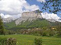 Mont Aiguille
 Clelles-Mens station
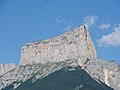 Mont Aiguille viewed from RN Clelles
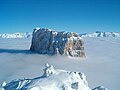 Mont Aiguille


References
- "Mont Aiguille". peakbagger.com. Retrieved 5 November 2019.
- "Mont Aiguille". Peakware.com. Archived from the original on 4 March 2016. Retrieved 2 January 2013.
- Google (2 January 2013). "Mont Aiguille" (Map). Google Maps. Google. Retrieved 2 January 2013.
- "Histoire et Événements" (in French). p. Le Mont Aiguille - Supereminet invius. Retrieved 31 December 2012.
- "Mont Aiguille (2086m)" [Mount Needle (2086m)] (in French). Mont Aiguille.com. 12 January 2009. Archived from the original on 16 June 2009. Retrieved 2 January 2013.
- "Geologie" (in French). p. Le Mont Aiguille - Supereminet invius. Retrieved 2 January 2013.
- "Mont Aiguille" (in French). Geol-Alp. 22 September 2011. Retrieved 31 December 2012.
- "L'ascension historique de 1492" [The historic ascent of 1492] (in French). Mont-Aiguille.com. 12 January 2009. Archived from the original on 16 June 2009. Retrieved 3 January 2013.
- Unsworth, Walt (1994). Hold the Heights: The Foundations of Mountaineering. Seattle: Penguin Books. pp. 19–20.
- "Alpinisme" [Alpinism] (in French). Mont Aiguille.com. 12 January 2009. Archived from the original on 11 July 2009. Retrieved 2 March 2013.
- IUCN Commission on National Parks and Protected Areas (November 1990). 1990 United Nations list of national parks and protected areas. IUCN. p. 89. ISBN 978-2-8317-0032-8.
External links
 Media related to Mont Aiguille at Wikimedia Commons
Authority control | |
|---|---|
| General |
|
| National libraries | |
На других языках
[de] Mont Aiguille
Der Mont Aiguille (frei übersetzt: Felsnadel) ist ein 2087 m hoher Berg in den französischen Alpen. Er liegt im nördlichsten Teil des Gemeindegebietes von Chichilianne. Er ist besonders wegen seiner Erstbesteigung im Jahre 1492 bekannt.- [en] Mont Aiguille
[fr] Mont Aiguille
Le mont Aiguille, localisé sur la commune de Chichilianne, est une dent avancée de la falaise orientale du massif du Vercors, à la limite du Trièves, au sud du département français de l'Isère en région Auvergne-Rhône-Alpes. C'est une des sept merveilles du Dauphiné. L'alpinisme rocheux (sur roche calcaire) y est pratiqué, en particulier sur la face nord-ouest.[it] Mont Aiguille
Il Mont Aiguille (2.087 m s.l.m.) è una montagna delle Prealpi del Vercors nelle Prealpi del Delfinato. Si trova nel dipartimento francese dell'Isère.[ru] Эгюий (гора)
Эгюи́й (фр. Aiguille — «игла») — горная вершина в массиве Веркор, Французских Предальп. Расположена в 58 километрах к югу от Гренобля, в коммуне Шишильянк департамента Изер. Гора является одним из Семи чудес Дофине. Эта гора — относительно ровная известняковая столовая гора, окружённая отвесными скалами. Территория, на которой расположена гора, в 1970 году включена в региональный природный парк Веркор. Эгюий известна известняковыми скалами, особенно на северо-западной стороне, которые популярны среди альпинистов. Первый подъём на гору был осуществлён 26 июня в 1492 году[2].Другой контент может иметь иную лицензию. Перед использованием материалов сайта WikiSort.org внимательно изучите правила лицензирования конкретных элементов наполнения сайта.
WikiSort.org - проект по пересортировке и дополнению контента Википедии