geo.wikisort.org - River
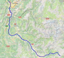
The Drac (French pronunciation: [dʁak]) is a 130-kilometre (81 mi) long river in southeastern France.[1] It is a left tributary of the river Isère. It is formed at the confluence of the Drac Noir and the Drac Blanc, which both rise in the southern part of the Massif des Écrins, high in the French Alps. It flows through several reservoirs on its course, including the Lac de Monteynard-Avignonet. It flows into the Isère at Grenoble. Its major tributary is the Romanche.
| Drac | |
|---|---|
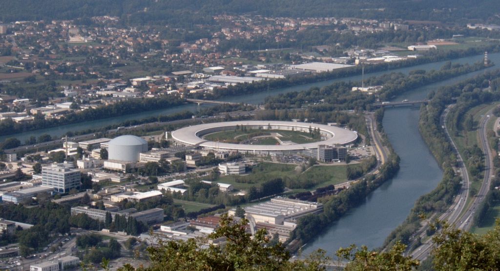 Confluence of the Drac with the Isère in Grenoble | |
 | |
| Location | |
| Country | France |
| Physical characteristics | |
| Source | |
| • location | Massif des Écrins |
| Mouth | |
• location | Isère |
• coordinates | 45°12′55″N 5°40′31″E |
| Length | 130 km (81 mi) |
| Basin size | 3,599 km2 (1,390 sq mi) |
| Discharge | |
| • average | 97 m3/s (3,400 cu ft/s) |
| Basin features | |
| Progression | Isère→ Rhône→ Mediterranean Sea |
The Drac flows through the following departments and towns:
- Hautes-Alpes: Saint-Bonnet-en-Champsaur
- Isère: Corps, Grenoble
The average flow of the Drac at Fontaine is 97 cubic metres per second (3,400 cu ft/s), with the highest monthly flows occurring in June, due to the melting of Alpine glaciers. The catchment area of the river is 3,599 square kilometres (1,390 sq mi),[2] which has an average rainfall of 859 millimetres (33.8 in).[3]
The name Drac, originally the Drau, is due to an attraction by the Occitan drac "imp", which is derived from the Latin dracō, meaning "Dragon". It is documented in the forms of Dracum (v. 1100), Dravus (1289) and the ribière dou Drau (1545). The word "Drac" means Dragon. In many legends the drac, in Occitan, is a genius of evil waters or a form of Satan that attracts children to drown.[4] Frédéric Mistral wrote in Félibrige Treasury:[4]
Drac of the Rhone was a winged monster and amphibian which carried on the body of a reptile the shoulders and the head of a beautiful young man. He lived the bottom of the river where he tried to attract, to devour it, the imprudent ones gained by the softness of its voice.
In December 1995, six children and their teacher were drowned in the river after the level of water rose due to the opening of the valves of a dam. They were there to see beavers. All of them died.[5]
References
- Sandre. "Fiche cours d'eau - Le Drac (W2--0200)".
- Bassin versant : Drac (Le), Observatoire Régional Eau et Milieux Aquatiques en PACA
- Drac at Fontaine Archived December 15, 2014, at the Wayback Machine
- "Dragons - Entre sciences et fictions" (in French). www.lahic.cnrs.f. Archived from the original on 2013-01-06. Retrieved 2009-03-04.
- "Drame du Drac notre enquête" (in French). hebdo.nouvelobs.com. 21 December 1995. Retrieved 2009-03-04.
Authority control | |
|---|---|
| General |
|
| National libraries | |
| Other |
|
На других языках
[de] Drac
Der Drac ist ein Fluss in Frankreich, der in den Regionen Provence-Alpes-Côte d’Azur und Auvergne-Rhône-Alpes verläuft. Sein Hauptquellbach Drac Noir entspringt im Pelvoux-Massiv, an der Nordwestflanke der Bergkette Crête de la Dent, nahe dem Col des Tourettes (2582 m). Die Quelle liegt im Nationalpark Écrins, im Gemeindegebiet von Orcières. Der Drac entwässert anfangs Richtung Nordwest durch die Landschaft Champsaur, schwenkt später in nördliche Richtung, durchquert den Großraum von Grenoble und mündet nach rund 130[2] Kilometern knapp nordwestlich davon, an der Gemeindegrenze von Sassenage und Saint-Égrève, als linker Nebenfluss in die Isère. Der Drac durchquert auf seinem Weg die Départements Hautes-Alpes und Isère. Er verläuft dabei etwa 90 km entlang der Route Napoléon.- [en] Drac (river)
[es] Río Drac
El río Drac es un río del Delfinado francés, que nace al sur del macizo de los Écrins, en el departamento de Altos Alpes, en la región de Provenza-Alpes-Costa Azul. Poco antes de llegar a la ciudad de Grénoble, recibe por la derecha las aguas del río Romanche, que viene del Oisans. Desemboca en el río Isère en Grénoble tras un curso de 130,5 km. Su cuenca comprende 3550 km².[it] Drac (fiume)
Il Drac è un fiume francese affluente di sinistra dell'Isère nel bacino del Rodano.[ru] Драк
Драк (фр. Drac) — река на юго-востоке Франции, в регионах Прованс — Альпы — Лазурный Берег и Овернь — Рона — Альпы. Длина — 130 км. Площадь водосборного бассейна насчитывает 3350 км². Средний многолетний годовой расход воды около 99 м³/с.Другой контент может иметь иную лицензию. Перед использованием материалов сайта WikiSort.org внимательно изучите правила лицензирования конкретных элементов наполнения сайта.
WikiSort.org - проект по пересортировке и дополнению контента Википедии