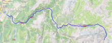
geo.wikisort.org - River
The Romanche (French pronunciation: [ʁɔmɑ̃ʃ] (![]() listen)) is a 78.3-kilometre (48.7 mi) long mountain river in southeastern France. It is a right tributary of the Drac, which is itself a tributary of the Isère.[1] Its drainage basin is 1,221 km2 (471 sq mi).[2] Its source is in the northern part of the Massif des Écrins, Dauphiné Alps. It flows into the Drac in Champ-sur-Drac, south of Grenoble. The road from Grenoble to Briançon over the Col du Lautaret runs through the Romanche valley. There are several mountain and ski resorts in the valley, including Alpe d'Huez, La Grave and Les Deux Alpes.
listen)) is a 78.3-kilometre (48.7 mi) long mountain river in southeastern France. It is a right tributary of the Drac, which is itself a tributary of the Isère.[1] Its drainage basin is 1,221 km2 (471 sq mi).[2] Its source is in the northern part of the Massif des Écrins, Dauphiné Alps. It flows into the Drac in Champ-sur-Drac, south of Grenoble. The road from Grenoble to Briançon over the Col du Lautaret runs through the Romanche valley. There are several mountain and ski resorts in the valley, including Alpe d'Huez, La Grave and Les Deux Alpes.
| Romanche | |
|---|---|
 The Romanche river in Écrins National Park | |
 | |
| Location | |
| Country | France |
| Physical characteristics | |
| Source | |
| • location | Dauphiné Alps |
| • coordinates | 44°58′26″N 6°21′58″E |
| • elevation | 2,140 m (7,020 ft) |
| Mouth | |
• location | Drac |
• coordinates | 45°5′23″N 5°43′33″E |
• elevation | 260 m (850 ft) |
| Length | 78.3 km (48.7 mi) |
| Basin size | 1,221 km2 (471 sq mi) |
| Basin features | |
| Progression | Drac→ Isère→ Rhône→ Mediterranean Sea |
The Romanche flows through the following departments and towns:
- Hautes-Alpes: La Grave
- Isère: Mont-de-Lans, Le Bourg-d'Oisans, Livet-et-Gavet, Vizille
References
- Sandre. "Fiche cours d'eau - La Romanche (W27-0400)".
- Bassin versant : Romanche (La), Observatoire Régional Eau et Milieux Aquatiques en PACA
| Wikimedia Commons has media related to Romanche River. |
Authority control | |
|---|---|
| General |
|
| National libraries | |
This Provence-Alpes-Côte d'Azur geography article is a stub. You can help Wikipedia by expanding it. |
This Auvergne-Rhône-Alpes geographical article is a stub. You can help Wikipedia by expanding it. |
На других языках
[de] Romanche
Die Romanche ist ein Gebirgsfluss in Frankreich, der in den Regionen Provence-Alpes-Côte d’Azur und Auvergne-Rhône-Alpes verläuft. Sie entspringt im Nordteil der zentralen Dauphiné-Alpen, im Nationalpark Écrins, unterhalb des Gletschers Plate des Agnaux, im Gemeindegebiet von Villar-d’Arêne, entwässert generell Richtung West bis Nordwest durch das nach ihr benannte Tal Vallée de la Romanche und mündet nach rund 78[3] Kilometern südlich von Grenoble, an der Gemeindegrenze von Champ-sur-Drac und Jarrie, als rechter Nebenfluss in den Drac. Auf ihrem Weg durchquert die Romanche die Départements Hautes-Alpes und Isère.- [en] Romanche
[it] Romanche
La Romanche è un torrente che scorre nel sud-est della Francia. La sorgente è situata nella parte settentrionale del massiccio des Écrins e si getta nel Drac a Champ-sur-Drac, a sud di Grenoble. La valle percorsa dal torrente viene chiamata Oisans.Другой контент может иметь иную лицензию. Перед использованием материалов сайта WikiSort.org внимательно изучите правила лицензирования конкретных элементов наполнения сайта.
WikiSort.org - проект по пересортировке и дополнению контента Википедии