geo.wikisort.org - Mountains
The Transantarctic Mountains (abbreviated TAM) comprise a mountain range of uplifted (primarily sedimentary) rock in Antarctica which extend, with some interruptions, across the continent from Cape Adare in northern Victoria Land to Coats Land. These mountains divide East Antarctica and West Antarctica. They include a number of separately named mountain groups, which are often again subdivided into smaller ranges.
| Transantarctic Mountains | |
|---|---|
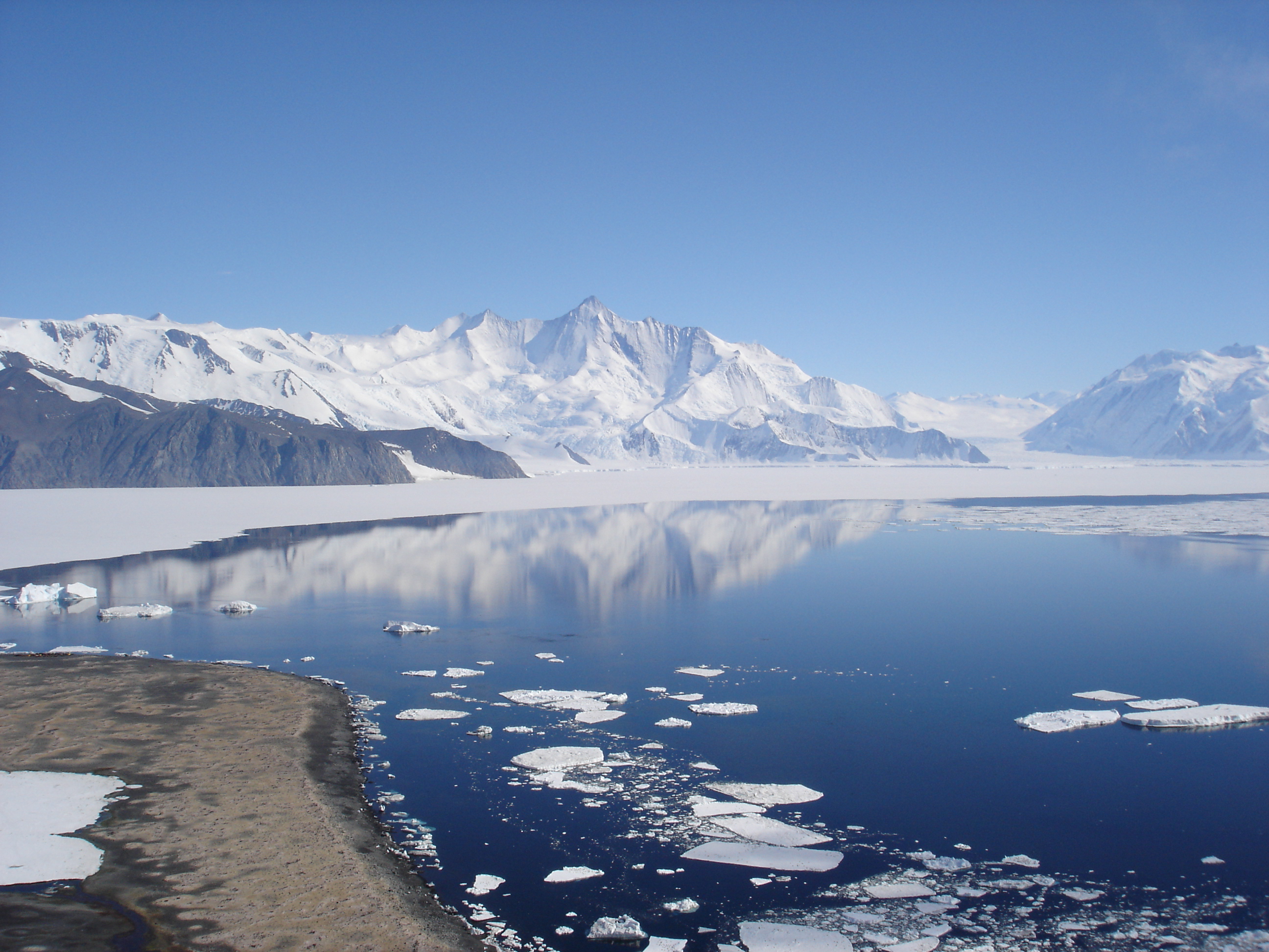
The Transantarctic Mountains in northern Victoria Land near Cape Roberts | |
| Highest point | |
| Peak | Mount Kirkpatrick |
| Elevation | 4,528 m (14,856 ft) |
| Coordinates | 84°20′S 166°25′E |
| Dimensions | |
| Length | 3,500 km (2,200 mi) |
| Geography | |
| Continent | Antarctica |
| Range coordinates | 85°S 175°W |
| Geology | |
| Age of rock | Cenozoic |
The range was first sighted by James Clark Ross in 1841 at what was later named the Ross Ice Shelf in his honour. It was first crossed during the British National Antarctic Expedition of 1901-1904.
Geography

The mountain range stretches between the Ross Sea and the Weddell Sea the entire width of Antarctica, hence the name. With a total length of about 3,500 km, the Transantarctic Mountains are one of the longest mountain ranges on Earth. The Antarctandes are even longer, having in common with the Transantarctic Mountains the ranges from Cape Adare to the Queen Maud Mountains, but extending thence through the Whitmore Mountains and Ellsworth Mountains up the Antarctic Peninsula. The 100–300 km wide range forms the boundary between East Antarctica and West Antarctica. The East Antarctic Ice Sheet bounds the TAM along their entire length on the Eastern Hemisphere side, while the Western Hemisphere side of the range is bounded by the Ross Sea (C.Michael Hogan. 2011) in Victoria Land from Cape Adare to McMurdo Sound, the Ross Ice Shelf from McMurdo Sound to near the Scott Glacier, and the West Antarctic Ice Sheet beyond.
The summits and dry valleys of the TAM are some of the few places in Antarctica not covered by ice, the highest of which rise more than 4,500 metres (14,800 ft) above sea level. The McMurdo Dry Valleys lie near McMurdo Sound and represent a special Antarctic phenomenon: landscapes that are snow and ice-free due to the extremely limited precipitation and ablation of ice in the valleys. The highest mountain of the TAM is 4,528 m high Mount Kirkpatrick in the Queen Alexandra Range. Isolated peaks surrounded by ice are referred to as nunataks.
Biology
Penguins, seals, and sea birds live along the Ross Sea coastline in Victoria Land, while life in the interior of the Transantarctic Range is limited to bacteria, lichens, algae, and fungi. Forests once covered Antarctica, including plentiful Wollemi Pine and Southern Beech.[1] However, with the gradual cooling associated with the break-up of Gondwana, these forests gradually disappeared.[1] It is believed that the last trees on the Antarctic continent were on Transantarctic Mountains.[1]
History
The Transantarctic Mountains were first seen by Captain James Ross in 1841 from the Ross Sea. The range is a natural barrier that must be crossed to reach the South Pole from the Ross Ice Shelf.
The first crossing of the Transantarctic Mountains took place during the 1902-1904 British National Antarctic Expedition at the Ross Ice Shelf. A reconnaissance party under the command of Albert Armitage reached 2700 m altitude in 1902. The following year a party under expedition leader Robert Falcon Scott crossed into East Antarctica at a location now known as Ferrar Glacier, named after the geologist of the expedition. They explored part of Victoria Land on the Antarctic Plateau before returning via the same glacier. In 1908, Ernest Shackleton's party crossed the mountains through the Beardmore Glacier. Robert Scott returned to that same glacier in 1911, while Roald Amundsen crossed the range via the Axel Heiberg Glacier.
Much of the range remained unexplored until the late 1940s and 1950s, when missions such as Operation Highjump and the International Geophysical Year (IGY) made extensive use of aerial photography and concentrated on a thorough investigation of the entire continent. The name "Transantarctic Mountains" was first applied to this range in a 1960 paper[2] by geologist Warren B. Hamilton, following his IGY fieldwork. It was subsequently recommended by the US-ACAN committee, a US authority for geographic names, in 1962. This purely descriptive label (in contrast to many other geographic names on Antarctica) is internationally accepted at present.
The Leverett Glacier in the Queen Maud Mountains is the planned route through the TAM for the overland supply road between McMurdo Station and Amundsen–Scott South Pole Station.
Geology


The Transantarctic Mountains are considerably older than other mountain ranges of the continent that are mainly volcanic in origin. The range was uplifted during the opening of the West Antarctic Rift System to the east, beginning about 65 million years ago in the early Cenozoic.
The mountains consist of sedimentary layers lying upon a basement of granites and gneisses. The sedimentary layers include the Beacon Supergroup sandstones, siltstones, and coal deposited beginning in the Silurian period and continuing into the Jurassic. In many places the Beacon Supergroup has been intruded by dikes and sills of Jurassic age Ferrar Dolerite. Many of the fossils found in Antarctica are from locations within these sedimentary formations.
Ice from the East Antarctic ice sheet flows through the Transantarctic Mountains via a series of outlet glaciers into the Ross Sea, Ross Ice Shelf, and West Antarctic Ice Sheet. These glaciers generally flow perpendicular to the orientation of the range and define subranges and peak groups. It has been thought that many of these outlet glaciers follow the traces of large-scale geologic faults. However, the ice flow theories will be re-evaluated in light of new data from recent ice-penetrating radar surveys which revealed the presence of three previously unknown deep subglacial valleys affecting the "mountainous subglacial topography beneath the ice divide".[3] These geographic features are likely to have a significant impact on models and calculations related to ice flow through the Transantarctic Mountain region.[4]
See also


In geographic order from the Ross Sea towards the Weddell Sea:
Victoria Land
- Lillie Glacier
- Concord Mountains
- Cape Adare
- Admiralty Mountains
- Cape Hallett
- Tucker Glacier
- Victory Mountains
- Mariner Glacier
- Aviator Glacier
- Terra Nova Bay
- Priestley Glacier
- Prince Albert Mountains
- David Glacier and Drygalski Ice Tongue
- Mackay Glacier
- McMurdo Dry Valleys
- Ferrar Glacier
- McMurdo Sound
Central TAM
- Mulock Glacier
- Byrd Glacier
- Nimrod Glacier
- Queen Alexandra Range
- Beardmore Glacier
- Taz Glacier
Queen Maud Mountains
- Shackleton Glacier
- Liv Glacier
- Amundsen Glacier
- Scott Glacier
- Bush Mountains
- Commonwealth Range
- Dominion Range
- Herbert Range
- Prince Olav Mountains
- Hughes Range
- Supporters Range
- Zorawar Range
"Southern" TAM
- Reedy Glacier
- Horlick Mountains
- Thiel Mountains
- Pensacola Mountains
- Support Force Glacier
- Foundation Ice Stream
- Shackleton Range
- Theron Mountains
- Bailey Ice Stream
Further reading
- Gunter Faure, Teresa M. Mensing, The Transantarctic Mountains: Rocks, Ice, Meteorites and Water, Springer
- Damien Gildea, Transantarctic Mountains - Mountaineering in Antarctica: Travel Guide
- Sokol, E. R., C. W. Herbold, C. K. Lee, S. C. Cary, and J. E. Barrett, Local and regional influences over soil microbial metacommunities in the Transantarctic Mountains, Ecosphere 4(11):136. https://dx.doi.org/10.1890/ ES13-00136.1 2013
- I.B. Campbell, G.G.C. Claridge, Antarctica: Soils, Weathering Processes and Environment, PP 30 – 32
- A.R. Lewis, D.R. Marchant, A.C. Ashworth, S.R. Hemming, M.L. Machlus, Major middle Miocene global climate change: Evidence from East Antarctica and the Transantarctic Mountains
References
- Woodford, J. 2000. The Wollemi Pine. Melbourne: Text Publishing. pp. 85-104
- Hamilton, Warren B. (1960). "New interpretation of Antarctic tectonics." Geological Survey Research 1960 – Short Papers in the Geological Sciences, pp. B379–380. Washington DC: US Geological Survey. https://books.google.com/books?id=iGpXAAAAMAAJ&pg=SL2-PA379&lpg=SL2-PA379
- Winter, K.; Ross, N.; et al. (2018). "Topographic Steering of Enhanced Ice Flow at the Bottleneck Between East and West Antarctica". Geophysical Research Letters. 45 (10): 4899–907. Bibcode:2018GeoRL..45.4899W. doi:10.1029/2018GL077504.
- Winter, 2018
External links
- Map of the Transantarctic Mountains
- Transantarctic Mountains at Peakbagger.com
- C.Michael Hogan. 2011. Ross Sea. Eds. P. Saundry and C.J. Cleveland. Encyclopedia of Earth. National Council for Science and the Environment. Washington DC
Antarctica | ||||||||
|---|---|---|---|---|---|---|---|---|
| Geography |
|  | ||||||
| History |
| |||||||
| Politics |
| |||||||
| Society |
| |||||||
| Famous explorers |
| |||||||
| ||||||||
Authority control | |
|---|---|
| General |
|
| National libraries | |
На других языках
[de] Transantarktisches Gebirge
Das Transantarktische Gebirge ist eine Bergkette in Antarktika, die sich mit einigen Unterbrechungen zwischen Kap Adare im Viktorialand und dem Coatsland erstreckt.- [en] Transantarctic Mountains
[es] Montañas Transantárticas
Las montañas Transantárticas —en ocasiones cordillera Transantártica— es una larga cadena montañosa ubicada en la Antártida que atraviesa gran parte del continente de lado a lado, desde el cabo Adare en la Tierra de Victoria hasta la Tierra de Coats, ya en el mar de Weddell. Separa, de un lado, la Antártida Oriental y, del otro, la Antártida occidental y la costa oeste del mar de Ross. Está entrecortada por numerosos glaciares alimentados por el indlandsis de la Antártida Oriental que se expande desde la meseta antártica. Culmina a 4528 m[1] sobre el nivel del mar en el monte Kirkpatrick y tiene veinte picos de al menos 4000 m de altitud. Comprende varios grupos de montaña continuos pero con distintos nombres, que van desde el oeste del mar de Ross y los lados occidentales y australes de la barrera de hielo de Ross; también las montañas Horlick, la cordillera Thiel, las montañas Pensacola, la cordillera Shackleton y las montañas Theron. A pesar del clima polar que reina en ella, el hielo no está presente en toda la cordillera, como en los valles secos de McMurdo donde las precipitaciones son escasas y la evaporación intensa en verano, aunque logran formarse brevemente ríos intermitentes salidos de los glaciares que se derriten; en invierno suele hacer demasiado frío para que caiga nieve, sobre todo en el sur y en altitudes elevadas, donde se acumula principalmente bajo el efecto del viento. Estas condiciones explican por qué la vida es escasa en la cordillera, concentrada principalmente en la costa del mar de Ross donde viven focas y aves, especialmente pingüinos. La cadena es una de las más antiguas de la Tierra, data del Cámbrico y es el resultado de una asociación entre rift y subducción, alternando períodos de vulcanismo, de metamorfismo y de erosión-sedimentación. El relieve actual se debe a una levantamiento que alcanzó su paroxismo en el Eoceno, pero cuyo origen aún no se comprende bien.[fr] Chaîne Transantarctique
La chaîne Transantarctique, ou monts Transantarctiques, est une longue chaîne de montagnes située en Antarctique et traversant une grande partie du continent, de la terre Victoria à la mer de Weddell, en séparant sa partie orientale d'une part de sa partie occidentale et de la côte ouest de la mer de Ross d'autre part. Elle est entrecoupée par de nombreux glaciers alimentés par l'inlandsis Est-Antarctique et s'épanchant depuis le plateau Antarctique. Elle culmine à 4 528 mètres d'altitude au mont Kirkpatrick et possède vingt sommets d'au moins 4 000 mètres d'altitude. Malgré le climat polaire qui y règne, la glace n'est pas partout présente dans la chaîne, à l'instar des vallées sèches de McMurdo où les précipitations sont rares et l'évaporation intense en été, même si des cours d'eau intermittents issus de la fonte des glaciers parviennent brièvement à se former ; en hiver il fait généralement trop froid pour que la neige puisse tomber, en particulier au sud et à haute altitude, où elle s'accumule essentiellement sous l'effet du vent. Ces conditions expliquent que la vie est rare dans la chaîne, pour l'essentiel concentrée sur la côte de la mer de Ross où vivent des phoques et des oiseaux, notamment des manchots. La chaîne est l'une des plus anciennes sur Terre, datant du Cambrien, et résulte d'une association entre rift et subduction, alternant périodes de volcanisme, de métamorphisme et d'érosion–sédimentation. Le relief actuel est dû à une surrection atteignant son paroxysme à l'Éocène, mais dont l'origine est encore mal comprise.[ru] Трансантарктические горы
Трансантарктические горы — горный хребет, расположенный поперёк Антарктиды между мысом Адэр (север Земли Виктории) и Землёй Котса. Разделяет Западную и Восточную Антарктиду и состоит из отдельных горных систем, которые, в свою очередь, также часто разделяют на более мелкие хребты. В состав Трансантарктических гор входят хребет Шеклтона[en], массив Дьюфека, горы Пенсакола, хребет Куин-Мод, хребет Куин-Александра, горы Хорлика[en], хребет Британия, горы Принца Альберта[en] и горы Адмиралти[2].Другой контент может иметь иную лицензию. Перед использованием материалов сайта WikiSort.org внимательно изучите правила лицензирования конкретных элементов наполнения сайта.
WikiSort.org - проект по пересортировке и дополнению контента Википедии