geo.wikisort.org - Mountains
The Stanovoy Highlands (Russian: Станово́е наго́рье) or Stanovoy Uplands is a mountain range in the Transbaikal region of Siberia, Russia.[1]
| Stanovoy Highlands | |
|---|---|
 View of the Southern Muya, the subrange of the highlands with the highest altitudes. | |
| Highest point | |
| Peak | Pik BAM |
| Elevation | 3,072 m (10,079 ft) |
| Coordinates | 56°51′54.85″N 117°34′47.32″E |
| Dimensions | |
| Length | 700 km (430 mi) ENE-WSW |
| Geography | |
  | |
| Country | Russia |
| Federal subject | Buryatia |
| Range coordinates | 56°5′0″N 114°30′0″E |
| Parent range | South Siberian Mountains |
Geography
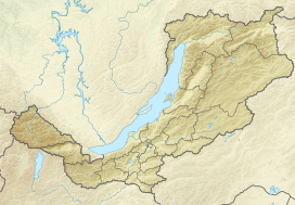
The Stanovoy Highlands are a mountainous area between the Patom Highlands to the north and the Vitim Plateau to the south. To the northeast they border with the Olyokma-Chara Plateau —in the upper reaches of the Chara river. The ranges of the highlands stretch roughly in a WSW / ENE direction between the North Baikal Highlands in the west and the Olyokma River in the east. There are large intermontane basins, such as the Muya Depression and the Chara Depression at altitudes ranging between 500 m (1,600 ft) and 1,000 m (3,300 ft).[2]
Subranges
The system of the Stanovoy Highlands comprises a group of subranges, including the following:[3]
- Southern Muya Range (Южно-Муйский хребет), highest point Muisky Gigant, 3,067 metres (10,062 ft)
- Northern Muya Range (Северо-Муйский хребет), highest point 2,537 metres (8,323 ft)
- Kodar Range (Кодар), highest point Pik BAM, 3,072 metres (10,079 ft)
- Udokan Range (Удокан), highest point 2,561 metres (8,402 ft)
- Kalar Range, highest point Skalisty Golets, 2,519 metres (8,264 ft)
- Delyun-Uran Range (Делюн-Уранский Хребет), highest point 2,399 metres (7,871 ft)
Hydrography
The Stanovoy mountain system is cut across from south to north by the deep valley of river Vitim, a right tributary of the Lena. Many left (Muya, Mamakan, Mama, Bolshoy Chuya) and right (Kalakan, Kalar, Konda, Sigikta) tributaries of the Vitim originate from its ranges. Likewise for some of the left tributaries of the Olyokma, such as the Diri-Yurya, Imangra, Khani, Oryus-Miele and the Chara with the Tokko.
Rivers Upper Angara, flowing into Lake Baikal, and Chaya, a right tributary of the Lena, have their sources in the western parts of the mountain system.[4][5] There are also mountain lakes in the range, such as Dorong.[6]
See also
- List of mountains and hills of Russia
 Siberia portal
References
- Кулаков, В.С.; Юргенсон, Г.А. "Становое нагорье" [Stanovoy Highlands] (in Russian). Энциклопедия Забайкалья. Retrieved 29 August 2015.
- O-50 USSR Topographic map
- Oleg Leonidovič Kryžanovskij, A Checklist of the Ground-beetles of Russia and Adjacent Lands. p. 15
- National atlas of Russia
- Stanovoy Highlands // Great Soviet Encyclopedia: in 30 vols. / Ch. ed. A.M. Prokhorov. - 3rd ed. - M. Soviet Encyclopedia, 1969-1978.
- "N-49 Chart (in Russian)". Retrieved 8 October 2021.
External links
 Media related to Stanovoy Highlands at Wikimedia Commons
| Authority control: National libraries |
|---|
This Siberian Federal District location article is a stub. You can help Wikipedia by expanding it. |
На других языках
[de] Stanowoihochland
Das Stanowoihochland (russisch Становое нагорье, wiss. Transliteration Stanovoe nagor'e) in Sibirien (Russland, Asien) ist ein bis 3072,6 m[1] hohes Hochgebirgssystem der Südsibirischen Gebirge. Etwa 670 km ostsüdöstlich liegt das Stanowoigebirge.- [en] Stanovoy Highlands
[it] Altopiano Stanovoj
L'Altopiano Stanovoj (in russo: Становое нагорье, Stanovoe nagor'e?) è un sistema montuoso della Dauria, nella Siberia Orientale meridionale. Si estende nel Territorio della Transbajkalia e nella Buriazia, in Russia.[ru] Становое нагорье
Станово́е наго́рье[1] — горная система в Забайкалье протяжённостью около 700 км от северной оконечности Байкала до среднего течения реки Олёкмы в направлении восток — северо-восток. Включает высокогорные хребты Южно-Муйский, Северо-Муйский, Кодар, Удокан, Каларский и крупные межгорные котловины байкальского типа на высоте 500—1000 м (Верхнеангарская, Муйско-Куандинская, Верхнечарская), максимальная высота Станового нагорья составляет 3072 метра.Другой контент может иметь иную лицензию. Перед использованием материалов сайта WikiSort.org внимательно изучите правила лицензирования конкретных элементов наполнения сайта.
WikiSort.org - проект по пересортировке и дополнению контента Википедии