geo.wikisort.org - River
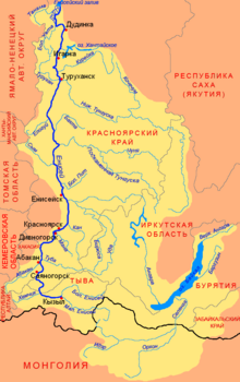
The Upper Angara (Russian: Верхняя Ангара, Verkhnyaya Angara; Buryat: Дээдэ Ангар, Deede Angar) is a river in Buryatia, Siberia to the northeast of Lake Baikal. the third longest river in the Baikal basin. It is 438 kilometres (272 mi) long, and has a drainage basin of 21,400 square kilometres (8,300 sq mi).[1]
| Upper Angara | |
|---|---|
 View from the BAM railway bridge across the Upper Angara near Novy Uoyan | |
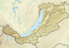 Mouth location in Buryatia, Russia | |
| Location | |
| Country | Russia |
| Physical characteristics | |
| Source | Delyun-Uran Range Stanovoy Highlands |
| • coordinates | 56°36′51″N 113°45′21″E |
| • elevation | 1,600 m (5,200 ft) |
| Mouth | Lake Baikal |
• coordinates | 55°42′24″N 109°52′33″E |
| Length | 438 km (272 mi) |
| Basin size | 21,400 km2 (8,300 sq mi) |
| Discharge | |
| • average | 258 m3/s (9,100 cu ft/s) |
| Basin features | |
| Progression | Lake Baikal→ Angara→ Yenisey→ Kara Sea |
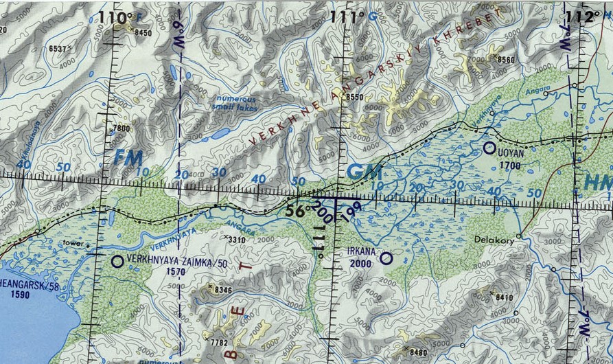
The Baikal–Amur Mainline runs along the north side of the river northeast up its valley, crossing between Anamakit and Novy Uoyan and crossing the river a second time upstream before heading into the mountains.[2]
Course
The Upper Angara rises at about 1,600 m (5,200 ft) in an area of small glacial lakes of the Delyun-Uran range, right by the Northern Muya Range, Stanovoy Highlands. It its upper course the river flows in a WSW direction across mountainous terrain, with rapids and waterfalls. It enters then a floodplain and crosses the spurs of the Upper Angara and the Barguzin ranges. Near Yanchukan it flows through the Upper Angara tectonic basin. Finally it ends in Lake Baikal forming a delta in the shallow northern end of the lake, separated from the deep part by long sandy spits, including Yarki Island. The Upper Angara is navigable in its last stretch.[3]
The main tributaries of the Upper Angara are the 64 km (40 mi) long Angarakan, the 87 km (54 mi) long Yanchui, the 124 km (77 mi) long Churo and the 245 km (152 mi) long Kotera.[1]
 |
 |
See also
References
- "Река Верхняя Ангара in the State Water Register of Russia". textual.ru (in Russian).
- Wikimapia approximate site of basin
- Верхняя Ангара - Water of Russia
External links
- , Encyclopædia Britannica, 9th ed., Vol. II, New York: Charles Scribner's Sons, 1878, p. 26.
This Buryatia location article is a stub. You can help Wikipedia by expanding it. |
This article related to a river in Russia is a stub. You can help Wikipedia by expanding it. |
На других языках
[de] Obere Angara
Die Obere Angara (russisch Ве́рхняя Ангар́а/Werchnjaja Angara; burjatisch Дээдэ Ангар) ist ein 438 km[2] langer, nordöstlicher Zufluss des Baikalsees in Ostsibirien (Russland, Asien).- [en] Upper Angara
[it] Verchnjaja Angara
La Verchnjaja Angara (anche traslitterata come Verhnjaja Angara; in russo, Angara Superiore) è un fiume della Russia siberiana centro-orientale (Repubblica Autonoma della Buriazia), immissario del lago Bajkal.[ru] Верхняя Ангара
Ве́рхняя Ангара́ (бур. Дээдэ Ангар мүрэн) — река в России на севере Бурятии, вторая по полноводности после Селенги река, впадающая в Байкал. Течёт по территории Муйского и Северо-Байкальского районов.Другой контент может иметь иную лицензию. Перед использованием материалов сайта WikiSort.org внимательно изучите правила лицензирования конкретных элементов наполнения сайта.
WikiSort.org - проект по пересортировке и дополнению контента Википедии