geo.wikisort.org - River
The Kalar (Russian: Калар), known as the Levoy Chinoy in its upper section, is a river in Zabaykalsky Krai, southern East Siberia, Russia. It is 511 kilometres (318 mi) long, and has a drainage basin of 17,400 square kilometres (6,700 sq mi).[1] The area through which the river flows is mountainous in most of its length with frequent rapids in the riverbed.[2][3] The waters are rich in fish, including grayling, lenok, taimen and whitefish, among other species. In the International scale of river difficulty the Kalar is a Class III - IV destination for rafting and kayaking.[4]
| Kalar | |
|---|---|
 View of the river in mid-course | |
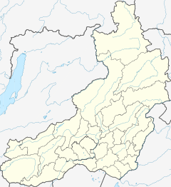 Mouth location in Zabaykalsky Krai, Russia | |
| Location | |
| Country | Russia |
| Federal subject | Zabaykalsky Krai |
| Physical characteristics | |
| Source | Udokan Range Stanovoy Highlands |
| • coordinates | 56°31′58″N 118°37′11″E |
| • elevation | 1,612 m (5,289 ft) |
| Mouth | Vitim |
• coordinates | 55°21′53″N 116°15′49″E |
• elevation | 561 m (1,841 ft) |
| Length | 511 km (318 mi) |
| Basin size | 17,400 km2 (6,700 sq mi) |
| Discharge | |
| • average | 150 m3/s (5,300 cu ft/s) |
| Basin features | |
| Progression | Vitim→ Lena→ Laptev Sea |
The Kalar has lent its name to a number of other geographic features, including the Kalar Range, the local Kalar District, as well as Sredny Kalar (Middle Kalar) village by its right bank 156 kilometres (97 mi) from its mouth.[4]
Course
The Kalar is a right tributary of the Vitim. Its sources are between the Udokan Range and the Kalar Range subranges of the Stanovoy Highlands.[4] In its upper course it cuts eastwards across the Kalar Range in a wide arc as the Levoy Chinoy. The river flows at the foot of Skalisty Golets, the highest peak of the Kalar Range. Then it turns and flows roughly southwestwards as the Kalar. The Kalar range rises above the northern banks of the river and the Yankan Range above the southern, separating it from the course of the Kalakan to the south. Finally, at the border with Buryatia the Kalar meets the Vitim 900 kilometres (560 mi) from its mouth in the Lena.[4][2]
The longest tributaries of the Kalar are the 71 km (44 mi) long Katugin and the 71 km (44 mi) long Chukchudu from the right, and the 89 km (55 mi) long Dzhemku, the 60 km (37 mi) long Lucha and the 53 km (33 mi) long Chitkanda from the left. The river is frozen between mid October and mid May. About 20% of the basin area is covered by forests.[4]
 |
See also
References
- "Река Калар in the State Water Register of Russia". textual.ru (in Russian).
- Kalar // Great Soviet Encyclopedia: [in 30 vols.] / Ch. ed. A.M. Prokhorov. - 3rd ed. - M. Soviet Encyclopedia, 1969-1978.
- Google Earth
- Kalar - Water of Russia
External links
 Media related to Kalar River at Wikimedia Commons
This article related to a river in Russia is a stub. You can help Wikipedia by expanding it. |
На других языках
[de] Kalar
Der Kalar (russisch Кала́р) ist ein rechter Nebenfluss des Witim in der Region Transbaikalien im Südosten Sibiriens.- [en] Kalar (river)
[it] Kalar
Il Kalar (in russo: Калар?; nell'alto corso conosciuto con il nome di Čina, in russo: Чина?) è un fiume della Russia siberiana orientale, affluente di destra del Vitim (bacino idrografico della Lena). Scorre nei rajon Kalarskij e Tungokočenskij del Territorio della Transbajkalia.[ru] Калар
Кала́р[3] (в верховье — Чина[3], Левая Чина[3]) — река в Забайкальском крае России, правый приток Витима. Длина реки — 511 км, площадь бассейна — 17 400 км²[4]. Средний расход воды — 150 м³/с.[источник не указан 425 дней]Другой контент может иметь иную лицензию. Перед использованием материалов сайта WikiSort.org внимательно изучите правила лицензирования конкретных элементов наполнения сайта.
WikiSort.org - проект по пересортировке и дополнению контента Википедии