geo.wikisort.org - Mountains
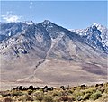
Sawmill Point is a 9,429-foot-elevation (2,874 meter) mountain summit located in Inyo County, California. It is situated 2.6 miles east of the crest of the Sierra Nevada mountain range, in the John Muir Wilderness, on land managed by Inyo National Forest. It is also 10.5 miles (16.9 km) northwest of the community of Independence, and 2.6 miles (4.2 km) east of proximate parent Colosseum Mountain. Topographic relief is significant as the summit rises 4,770 feet (1,454 meters) above Owens Valley in two miles. The Sawmill Pass Trail traverses the east and south slopes of the peak, providing an approach option, and access to the John Muir Trail.
| Sawmill Point | |
|---|---|
 Northeast aspect, centered | |
| Highest point | |
| Elevation | 9,429 ft (2,874 m)[1] |
| Prominence | 591 ft (180 m)[2] |
| Parent peak | Colosseum Mountain (12,473 ft)[3] |
| Isolation | 2.58 mi (4.15 km)[3] |
| Coordinates | 36°55′01″N 118°19′14″W[4] |
| Geography | |
 Sawmill Point Location in California  Sawmill Point Sawmill Point (the United States) | |
| Location | John Muir Wilderness |
| Country | United States of America |
| State | California |
| County | Inyo County |
| Parent range | Sierra Nevada |
| Topo map | USGS Aberdeen |
| Geology | |
| Age of rock | Cretaceous |
| Mountain type | Fault block |
| Climbing | |
| First ascent | < 1953 |
| Easiest route | class 3 scrambling[5] |
History
The landform's toponym has been officially adopted by the United States Board on Geographic Names.[4] The peak is named in association with Sawmill Creek, which in turn was named for the sawmill that James W. Smith operated along the creek in the 1870s.[6] The first recorded ascent of the summit was made by Art J. Reyman and Fred L. Jones on January 11, 1953, by ascending the northeast ridge.[5] The party was not the first on the summit however, because they found cairns, but no record.
Climate
According to the Köppen climate classification system, Sawmill Point is located in an alpine climate zone.[7] Most weather fronts originate in the Pacific Ocean, and travel east toward the Sierra Nevada mountains. As fronts approach, they are forced upward by the peaks (orographic lift), causing them to drop their moisture in the form of rain or snowfall onto the range. Precipitation runoff from this mountain drains into Division and Sawmill creeks, thence Owens Valley.
See also
 Mountains portal
- List of mountain peaks of California
Gallery
 East aspect
 Sawmill Lake and Owens Valley from Sawmill Pass,
by Ansel Adams circa 1941


References
- United States Geological Survey topographical map - Aberdeen
- "Sawmill Point, California". Peakbagger.com. Retrieved 2022-07-15.
- "Sawmill Point - 9,429' CA". listsofjohn.com. Retrieved 2022-07-15.
- "Sawmill Point". Geographic Names Information System. United States Geological Survey, United States Department of the Interior. Retrieved 2022-07-15.
- Jones, Fred L. (1954). "A Climber's Guide to the High Sierra".
- Francis P. Farquhar, Place Names of the High Sierra (1926)
- "Climate of the Sierra Nevada". Encyclopædia Britannica.
External links
- Sawmill Point weather forecast
Другой контент может иметь иную лицензию. Перед использованием материалов сайта WikiSort.org внимательно изучите правила лицензирования конкретных элементов наполнения сайта.
WikiSort.org - проект по пересортировке и дополнению контента Википедии