geo.wikisort.org - Mountains
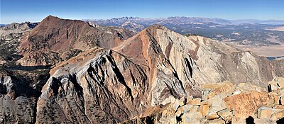
Laurel Mountain is a peak in Mono County, California. It lies in the Sherwin Range of the Sierra Nevada and is in the Inyo National Forest and the John Muir Wilderness. It reaches a height of 11,818 feet (3,602 m)[1] and is largely composed of metamorphic rock caused by contact with an intruding pluton in the late Cretaceous.[4]

| Laurel Mountain | |
|---|---|
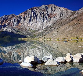
 Laurel Mountain, from the shore of Convict Lake | |
| Highest point | |
| Elevation | 11,818 ft (3,602 m) NAVD 88[1] |
| Prominence | 1,018 ft (310 m)[2] |
| Coordinates | 37°34′49″N 118°53′29″W[1] |
| Geography | |
| Location | Mono County, California, United States |
| Parent range | Sherwin Range, Sierra Nevada |
| Topo map | USGS Bloody Mountain |
| Climbing | |
| First ascent | 1926 by Norman Clyde[3] |
| Easiest route | Hike, class 1[3] |
References
- "Laurel". NGS Data Sheet. National Geodetic Survey, National Oceanic and Atmospheric Administration, United States Department of Commerce. Retrieved 2012-12-20.
- "Laurel Mountain, California". Peakbagger.com. Retrieved 2014-01-17.
- Secor, R.J. (2009). The High Sierra Peaks, Passes, and Trails (3rd ed.). Seattle: The Mountaineers. p. 367. ISBN 978-0898869712.
- Lackey, JS; Valley, JW (2004). "Complex patterns of fluid flow during wollastonite formation in calcareous sandstones at Laurel Mountain, Mt. Morrison Pendant, California". GSA Bulletin. 116 (1–2): 76–93. doi:10.1130/B25239.1.
External links
- "Laurel Mountain". Geographic Names Information System. United States Geological Survey, United States Department of the Interior.
- "Laurel Mountain". SummitPost.org.
Текст в блоке "Читать" взят с сайта "Википедия" и доступен по лицензии Creative Commons Attribution-ShareAlike; в отдельных случаях могут действовать дополнительные условия.
Другой контент может иметь иную лицензию. Перед использованием материалов сайта WikiSort.org внимательно изучите правила лицензирования конкретных элементов наполнения сайта.
Другой контент может иметь иную лицензию. Перед использованием материалов сайта WikiSort.org внимательно изучите правила лицензирования конкретных элементов наполнения сайта.
2019-2025
WikiSort.org - проект по пересортировке и дополнению контента Википедии
WikiSort.org - проект по пересортировке и дополнению контента Википедии