geo.wikisort.org - Mountains
Seven Gables is a 13,080-foot-elevation (3,987 meter) mountain summit located in the Sierra Nevada mountain range in Fresno County of northern California, United States.[3] It is situated between the east and south forks of Bear Creek in the John Muir Wilderness, on land managed by Sierra National Forest. It is set 9 miles (14 km) southeast of Lake Thomas A Edison, 1.2 miles (1.9 km) northwest of Gemini, and 3.2 miles (5.1 km) west-southwest of Feather Peak, the nearest higher neighbor.[1] Topographic relief is significant as it rises nearly 3,500 feet (1,067 meters) above Upper Bear Creek Meadows in approximately two miles. Seven Gables ranks as the 133rd highest summit in California.[2]
| Seven Gables | |
|---|---|
 Northeast aspect | |
| Highest point | |
| Elevation | 13,080 ft (3,990 m)[1] |
| Prominence | 1,120 ft (340 m)[1] |
| Parent peak | Feather Peak (13,260 ft)[2] |
| Isolation | 3.22 mi (5.18 km)[2] |
| Listing | Sierra Peaks Section |
| Coordinates | 37°18′39″N 118°50′01″W[3] |
| Geography | |
 Seven Gables Location in California  Seven Gables Seven Gables (the United States) | |
| Location | Fresno County California, U.S. |
| Parent range | Sierra Nevada[1] |
| Topo map | USGS Mount Hilgard |
| Geology | |
| Age of rock | Cretaceous |
| Mountain type | Fault block |
| Type of rock | granite |
| Climbing | |
| First ascent | 1894 |
| Easiest route | class 3[2] |
History
The first ascent of the summit was made September 20, 1894, by Theodore Solomons and Leigh Bierce.[4] Solomons also named it: "The south wall of the gap we found to be the side of a peak, the eccentric shape of which is suggested in the name Seven Gables, which we hastened to fasten upon it".[4] Impressed by the superlative view from the summit, Solomons wrote: "I was too awed to shout. The ideas represented by such words as lovely, beautiful, wild or terrible, cold or desolate, fail to compass it. Words are puny things, and the language of description quite as impotent as the painter's brush. Roughly speaking, one might say that the sight was sublime and awful."[5]
Joseph Nisbet LeConte and Clarence L. Cory climbed it on June 29, 1898, placing a Sierra Club register at the summit.[6][7] The class 5.9 Direct East Face, considered one of the classic climbing routes in the Sierra Nevada, was first climbed in 1981 by Claude Fiddler and Vern Clevenger.[8] Galen Rowell put up a new route in 1988.[9] This mountain's name has been officially adopted by the U.S. Board on Geographic Names.[3] Today this peak draws interest because it is on the Sierra Peaks Section's Mountaineers Peaks peak bagging list.
Climate
According to the Köppen climate classification system, Seven Gables is located in an alpine climate zone.[10] Most weather fronts originate in the Pacific Ocean, and travel east toward the Sierra Nevada mountains. As fronts approach, they are forced upward by the peaks, causing them to drop their moisture in the form of rain or snowfall onto the range (orographic lift). Precipitation runoff from this mountain drains into Bear Creek, a tributary of the South Fork San Joaquin River.
Gallery
 Seven Gables from Feather Peak. Vee Lake lower right.
 Northeast aspect
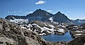
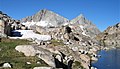


See also
References
- "Seven Gables, California". Peakbagger.com. Retrieved 2021-05-12.
- "Seven Gables - 13,074' CA". listsofjohn.com. Retrieved 2021-05-12.
- "Seven Gables". Geographic Names Information System. United States Geological Survey, United States Department of the Interior. Retrieved 2021-05-12.
- Francis P. Farquhar, Place Names of the High Sierra (1926)
- Steve Roper, 1997, The Sierra High Route: Traversing Timberline Country, Mountaineers Books, ISBN 9780898865066, page 133.
- Hervey Voge, James W. Koontz II, and George Bloom, A Climber’s Guide to the High Sierra, (1954)
- Francis P. Farquhar, Sierra Club Bulletin, 1923, page 206.
- John Moynier, Claude Fiddler, 1993, Sierra Classics 100 Best Climbs in the High Sierra, Chockstone Press, ISBN 9780934641609, page 192.
- R. J. Secor, The High Sierra Peaks, Passes, Trails, 2009, Third Edition, Mountaineers Books, ISBN 9781594857386, page 330.
- Peel, M. C.; Finlayson, B. L.; McMahon, T. A. (2007). "Updated world map of the Köppen−Geiger climate classification". Hydrol. Earth Syst. Sci. 11. ISSN 1027-5606.
External links
- Weather forecast: Seven Gables
- Seven Gables rock climbing: Mountainproject.com
Другой контент может иметь иную лицензию. Перед использованием материалов сайта WikiSort.org внимательно изучите правила лицензирования конкретных элементов наполнения сайта.
WikiSort.org - проект по пересортировке и дополнению контента Википедии