geo.wikisort.org - Mountains
Mount Izaak Walton is a 12,077-foot-elevation (3,681 meter) mountain summit located in the Sierra Nevada mountain range in Fresno County of northern California, United States.[4] It is situated in the John Muir Wilderness, on land managed by Sierra National Forest. Mount Izaak Walton ranks as the 404th-highest summit in California.[3] Topographic relief is significant as the northwest aspect rises 1,800 feet (550 meters) above Izaak Walton Lake in approximately one mile. It is six miles northeast of Lake Thomas A Edison, and approximately 14 miles (23 km) south-southeast of the community of Mammoth Lakes. The peak is set on Silver Divide, so precipitation runoff from the north side of this mountain drains into Fish Creek which is a tributary of the San Joaquin River, and from the south slope to Mono Creek, also a tributary of the San Joaquin.
| Mount Izaak Walton | |
|---|---|
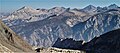
 North aspect | |
| Highest point | |
| Elevation | 12,077 ft (3,681 m)[1][2] |
| Prominence | 477 ft (145 m)[2] |
| Parent peak | Evon Benchmark (12,221 ft)[3] |
| Isolation | 1.12 mi (1.80 km)[3] |
| Listing | Sierra Peaks Section |
| Coordinates | 37°28′12″N 118°53′24″W[4] |
| Naming | |
| Etymology | Izaak Walton |
| Geography | |
 Mount Izaak Walton Location in California  Mount Izaak Walton Mount Izaak Walton (the United States) | |
| Location | Fresno County, California, U.S. |
| Parent range | Sierra Nevada[2] |
| Topo map | USGS Graveyard Peak |
| Geology | |
| Age of rock | Cretaceous |
| Mountain type | Horn[5] |
| Type of rock | Granodiorite |
| Climbing | |
| First ascent | 1971[6] |
| Easiest route | class 2 Southwest slope[7] |
History
This mountain's toponym was proposed in 1919 by Francis P. Farquhar and officially adopted in 1926 by the U.S. Board on Geographic Names to honor Izaak Walton (1593–1683), an English writer best known as the author of The Compleat Angler.[8][4] The connection being that the mountain is set at the head of Fish Creek and Izaak Walton was an avid fisherman.
The first ascent of the summit was made July 5, 1971, by Andy Smatko, Bill Schuler, and Ed Treacy.[9]
Climate
According to the Köppen climate classification system, Mount Izaak Walton is located in an alpine climate zone.[10] Most weather fronts originate in the Pacific Ocean, and travel east toward the Sierra Nevada mountains. As fronts approach, they are forced upward by the peaks (orographic lift), causing them to drop their moisture in the form of rain or snowfall onto the range.
Gallery
 South aspect of Mt. Izaak Walton centered at top. To left is parent Evon Benchmark, and to right are Red and White Mountain, Red Slate Mountain.
 Top of Mount Izaak Walton (centered, foreground) with Red and White Mountain (left of center). View from Evon Benchmark.
 Izaak Walton


See also
References
- Peter Browning, Place Names of the Sierra Nevada: From Abbot to Zumwalt, Wilderness Press, 1986, ISBN 9780899970479, page 108.
- "Mount Izaak Walton, California". Peakbagger.com. Retrieved 2022-05-19.
- "Izaak Walton, Mount - 12,077' CA". listsofjohn.com. Retrieved 2022-05-19.
- "Mount Izaak Walton". Geographic Names Information System. United States Geological Survey. Retrieved 2022-05-20.
- Mary Hill (2006), Geology of the Sierra Nevada, Revised Edition, University of California Press, ISBN 9780520936942, p. 296
- Steve Roper, The Climber's Guide to the High Sierra, 1976, Sierra Club Books, ISBN 9780871561473, page 340.
- R. J. Secor, The High Sierra Peaks, Passes, Trails, 2009, Third Edition, Mountaineers Books, ISBN 9781594857386, p. 362
- Francis P. Farquhar, Place Names of the High Sierra (1926)
- R. J. Secor, The High Sierra Peaks, Passes, Trails, 2009, Third Edition, Mountaineers Books, ISBN 9781594857386, p. 362
- "Climate of the Sierra Nevada". Encyclopædia Britannica.
External links
- Weather forecast: Mount Izaak Walton
- Mount Izaak Walton (photo): Flickr
| Mountains |
| |||||||||||
|---|---|---|---|---|---|---|---|---|---|---|---|---|
| Passes |
| |||||||||||
| Rivers | ||||||||||||
| Lakes | ||||||||||||
| Protected areas |
| |||||||||||
| Communities |
| |||||||||||
| Ski areas |
| |||||||||||
| Trails |
| |||||||||||

Другой контент может иметь иную лицензию. Перед использованием материалов сайта WikiSort.org внимательно изучите правила лицензирования конкретных элементов наполнения сайта.
WikiSort.org - проект по пересортировке и дополнению контента Википедии