geo.wikisort.org - Mountains
Mount Tekarra is a 2,694 metres (8,839 feet) mountain summit located in the Athabasca River valley of Jasper National Park, in the Canadian Rockies of Alberta, Canada. It is situated at the northwest end of the Maligne Range and is visible from Jasper and the Icefields Parkway.[4] Its nearest higher neighbor is The Watchtower, 7.0 km (4.3 mi) to the east.[1]
| Mount Tekarra | |
|---|---|
 Mount Tekarra | |
| Highest point | |
| Elevation | 2,694 m (8,839 ft)[1] |
| Prominence | 279 m (915 ft)[1] |
| Parent peak | The Watchtower (2791 m)[1] |
| Listing | Mountains of Alberta |
| Coordinates | 52°50′30″N 117°56′22″W[2] |
| Geography | |
Mount Tekarra Location of Mount Tekarra in Alberta  Mount Tekarra Mount Tekarra (Canada) | |
| Location | Jasper National Park Alberta, Canada |
| Parent range | Maligne Range Canadian Rockies |
| Topo map | NTS 83C13 Medicine Lake[2] |
| Geology | |
| Age of rock | Cambrian |
| Type of rock | Sedimentary rock |
| Climbing | |
| First ascent | 1915 by Morrison Bridgland[3] |
| Easiest route | Scramble |
History
The mountain was named by James Hector in 1859 for Tekarra, an Iroquois guide and hunter who accompanied Hector during his exploration of the Athabasca River during the Palliser Expedition.[3][5]
The first ascent of Mount Tekarra was made in 1915 by Morrison P. Bridgland (1878-1948), a Dominion Land Surveyor who named many peaks in Jasper Park and the Canadian Rockies.[3][6] The mountain's name was officially adopted in 1947 by the Geographical Names Board of Canada.[2]
Geology
Mount Tekarra is composed of sedimentary rock laid down during the Cambrian period and pushed east and over the top of younger rock during the Laramide orogeny.[7]
Climate
Based on the Köppen climate classification, Mount Tekarra is located in a subarctic climate with long, cold, snowy winters, and mild summers.[8] Temperatures can drop below -20 °C with wind chill factors below -30 °C. Precipitation runoff from Mount Tekarra drains into the Maligne River and Tekarra Creek, both tributaries of the Athabasca River.
See also
- Geography of Alberta
References
- "Mount Tekarra". Bivouac.com. Retrieved 2019-02-02.
- "Mount Tekarra". Geographical Names Data Base. Natural Resources Canada. Retrieved 2019-02-01.
- "Mount Tekarra". PeakFinder.com. Retrieved 2021-03-02.
- "Mount Tekarra, Alberta". Peakbagger.com.
- Place-names of Alberta. Ottawa: Geographic Board of Canada. 1928. p. 124.
- MacLaren, I.S. (2005). Mapper of Mountains M.P. Bridgland in the Canadian Rockies 1902-1930. With Eric Higgs, Gabrielle Zezulka-Mailloux. Edmonton, AB: The University of Alberta Press. ISBN 0-88864-456-6.
- Gadd, Ben (2008), Geology of the Rocky Mountains and Columbias
- Peel, M. C.; Finlayson, B. L.; McMahon, T. A. (2007). "Updated world map of the Köppen−Geiger climate classification". Hydrol. Earth Syst. Sci. 11: 1633–1644. ISSN 1027-5606.
Gallery
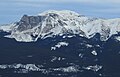 Mt. Tekarra from Marmot Basin Ski Resort
 Mount Tekarra from The Whistlers
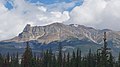 Mount Tekarra from the Athabasca Valley
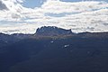 Mount Tekarra as seen from Roche Bonhomme summit


External links
- Parks Canada web site: Jasper National Park
- Mount Tekarra: weather forecast
Другой контент может иметь иную лицензию. Перед использованием материалов сайта WikiSort.org внимательно изучите правила лицензирования конкретных элементов наполнения сайта.
WikiSort.org - проект по пересортировке и дополнению контента Википедии