geo.wikisort.org - Mountains
Mount Shinn is a 10,995-foot-elevation (3,351 meter) mountain summit located west of the crest of the Sierra Nevada mountain range in Fresno County of northern California, United States.[1] It is set within the John Muir Wilderness, on land managed by Sierra National Forest. Precipitation runoff from this mountain drains north to Florence Lake via tributaries of the South Fork San Joaquin River. Topographic relief is significant as the summit rises 3,600 feet (1,100 meters) above this river in less than two miles.
| Mount Shinn | |
|---|---|
 West aspect | |
| Highest point | |
| Elevation | 10,995 ft (3,351 m)[1] |
| Prominence | 560 ft (171 m)[2] |
| Parent peak | Zingheim Heights (11,138 ft)[3] |
| Isolation | 3.96 mi (6.37 km)[3] |
| Coordinates | 37°12′44″N 118°55′10″W[1] |
| Naming | |
| Etymology | Charles Howard Shinn |
| Geography | |
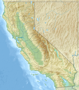 Mount Shinn Location in California  Mount Shinn Mount Shinn (the United States) | |
| Location | Fresno County, California, U.S. |
| Parent range | Sierra Nevada |
| Topo map | USGS Ward Mountain |
| Geology | |
| Age of rock | Cretaceous |
| Mountain type | Fault block |
| Type of rock | Granodiorite |
| Climbing | |
| First ascent | 1925 |
| Easiest route | class 2 West slope[4] |
History
The mountain's name was proposed by members of the U. S. Forest Service to honor Charles Howard Shinn (1852–1924), forest supervisor of Sierra National Forest.[5] He was also a charter member of the Sierra Club and author.[6] This landform's toponym was officially adopted in 1925 by the U.S. Board on Geographic Names.[1]
The first ascent of the summit was made August 8, 1925, by Francis A. Corey.[7]
Climate
According to the Köppen climate classification system, Mount Shinn is located in an alpine climate zone.[8] Most weather fronts originate in the Pacific Ocean, and travel east toward the Sierra Nevada mountains. As fronts approach, they are forced upward by the peaks (orographic lift), causing them to drop their moisture in the form of rain or snowfall onto the range.
Gallery
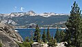 Northwest aspect of Mt. Shinn seen with Florence Lake
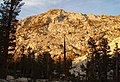 Evening on west slope
 Mt. Shinn sight pipe
 Commemorative plaque


See also
References
- "Mount Shinn". Geographic Names Information System. United States Geological Survey. Retrieved 2022-05-17.
- "Mount Shinn, California". Peakbagger.com. Retrieved 2022-05-17.
- "Shinn, Mount - 10,980' CA". listsofjohn.com. Retrieved 2022-05-17.
- R. J. Secor, The High Sierra Peaks, Passes, Trails, 2009, Third Edition, Mountaineers Books, ISBN 9781594857386.
- United States Geographic Board, Frank Bond (1926), Decisions of the United States Geographic Board, June, 1923-June, 1926, U.S. Government Printing Office, p. 29
- Francis P. Farquhar, Place Names of the High Sierra (1926)
- Fred L. Jones, A Climber’s Guide to the High Sierra, (1954)
- "Climate of the Sierra Nevada". Encyclopædia Britannica.
External links
- Weather forecast: Mount Shinn
- Mt. Shinn (photo): Flickr
| Mountains |
| |||||||||||
|---|---|---|---|---|---|---|---|---|---|---|---|---|
| Passes |
| |||||||||||
| Rivers | ||||||||||||
| Lakes | ||||||||||||
| Protected areas |
| |||||||||||
| Communities |
| |||||||||||
| Ski areas |
| |||||||||||
| Trails |
| |||||||||||

Другой контент может иметь иную лицензию. Перед использованием материалов сайта WikiSort.org внимательно изучите правила лицензирования конкретных элементов наполнения сайта.
WikiSort.org - проект по пересортировке и дополнению контента Википедии