geo.wikisort.org - Mountains
Mount Schaffer is a 2,691-metre (8,829-foot) mountain summit located one kilometre (0.62 mi) southwest of Lake O'Hara in Yoho National Park, in the Bow Range of the Canadian Rockies of British Columbia, Canada. Its nearest higher peak is Mount Biddle, 3.2 km (2.0 mi) to the southeast.[1] Mount Schaffer is situated 3.5 kilometres (2.2 mi) west of the Continental Divide, and 12 kilometres (7.5 mi) southeast of Field, British Columbia.
| Mount Schaffer | |
|---|---|
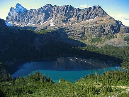
 Mount Schaffer seen from Lake O'Hara | |
| Highest point | |
| Elevation | 2,691 m (8,829 ft)[1] |
| Prominence | 46 m (151 ft)[1] |
| Parent peak | Mount Biddle (3320 m)[1] |
| Listing | Mountains of British Columbia |
| Coordinates | 51°20′40″N 116°20′24″W[2] |
| Geography | |
 Mount Schaffer Location of Mount Schaffer in British Columbia  Mount Schaffer Mount Schaffer (Canada) | |
| Location | British Columbia, Canada |
| District | Kootenay Land District |
| Parent range | Bow Range Canadian Rockies |
| Topo map | NTS 82N8 Lake Louise[2] |
| Geology | |
| Age of rock | Cambrian |
| Type of rock | sedimentary rock |
| Climbing | |
| First ascent | 1909 M. Goddard, W. Richardson[1] |
| Easiest route | Scramble class 3 |
History
The mountain was named in 1909 for Mary Schäffer Warren (1861–1939), an American-Canadian naturalist, illustrator, photographer, and writer.[1] Other reports have it being named in 1894 by Samuel E.S. Allen for Dr. Charles Schäffer (1838–1903), who was Mary's husband.[3]
The first ascent of the Mount Schaffer was made in 1909 by M. Goddard and W. Richardson.[4]
The mountain's name was made official in 1924 when approved by the Geographical Names Board of Canada.[2]
Geology
Mount Schaffer is composed of sedimentary rock laid down during the Precambrian to Jurassic periods.[5] Formed in shallow seas, this sedimentary rock was pushed east and over the top of younger rock during the Laramide orogeny.[6]
Climate
Based on the Köppen climate classification, Mount Schaffer is located in a subarctic climate zone with cold, snowy winters, and mild summers.[7] Temperatures can drop below −20 °C (−4 °F) with wind chill factors below −30 °C (−22 °F). Precipitation runoff from Mount Schaffer drains into tributaries of the Kicking Horse River which is a tributary of the Columbia River.
See also
- Geography of British Columbia
References
- "Mount Schaffer". Bivouac.com. Retrieved 2018-12-11.
- "Mount Schaffer". Geographical Names Data Base. Natural Resources Canada. Retrieved 2018-12-11.
- "Mount Schaffer". BC Geographical Names. Retrieved 2019-09-21.
- "Mount Schaffer". PeakFinder.com. Retrieved 2019-09-21.
- Belyea, Helen R. (1960). The Story of the Mountains in Banff National Park (PDF). parkscanadahistory.com (Report). Ottawa: Geological Survey of Canada. Archived (PDF) from the original on 2015-10-02. Retrieved 2019-09-13.
- Gadd, Ben (2008). Geology of the Rocky Mountains and Columbias.
- Peel, M. C.; Finlayson, B. L.; McMahon, T. A. (2007). "Updated world map of the Köppen−Geiger climate classification". Hydrol. Earth Syst. Sci. 11: 1633–1644. ISSN 1027-5606.
Gallery
 Mount Schäffer far right, Mount Biddle upper left corner
 Mount Schäffer seen above Lake O'Hara


External links
- Weather forecast: Mount Schaffer
- Parks Canada web site: Yoho National Park
- Climbing Mount Shaffer: Explor8ion.com
Places adjacent to Mount Schaffer | ||||||||||||||||
|---|---|---|---|---|---|---|---|---|---|---|---|---|---|---|---|---|
| ||||||||||||||||
Другой контент может иметь иную лицензию. Перед использованием материалов сайта WikiSort.org внимательно изучите правила лицензирования конкретных элементов наполнения сайта.
WikiSort.org - проект по пересортировке и дополнению контента Википедии