geo.wikisort.org - Mountains
Mount Victoria, 3,464 metres (11,365 ft), is a mountain on the border between British Columbia and Alberta in the Canadian Rockies. It is located just northeast of Lake O'Hara in Yoho National Park[5] and is also part of Banff National Park and is on the Continental Divide (which is the definition of the interprovincial boundary in this region). The mountain has two peaks, the south being the highest while the north peak is slightly lower at 3,388 metres (11,115 ft).[2]
- This article is for the mountain on the British Columbia-Alberta border in the Canadian Rockies. For the mountain in the Jervis Inlet area of the British Columbia Coast, see Mount Victoria (British Columbia).
| Mount Victoria | |
|---|---|
 Mt. Victoria in August 2011 as seen from Fairview Mountain | |
| Highest point | |
| Elevation | 3,464 m (11,365 ft)[1][2] |
| Prominence | 547 m (1,795 ft)[3] |
| Parent peak | Hungabee Mountain 3490 m |
| Listing | |
| Coordinates | 51°22′37″N 116°18′24″W[4] |
| Geography | |
Mount Victoria Location in Alberta  Mount Victoria Mount Victoria (British Columbia) | |
| Country | Canada |
| Provinces | Alberta and British Columbia |
| Parent range | Bow Range |
| Topo map | NTS 83C5 Fortress Lake |
| Climbing | |
| First ascent | 1897[3] |
| Easiest route | South Summit, South-East Ridge II[1] |
The mountain is located on the western buttress of Abbot Pass while Mount Lefroy lies on the eastern side.
The mountain was named by J. Norman Collie in 1897 for Queen Victoria.[1]
The first successful ascent was made in 1897 by J. Norman Collie, Arthur Michael, Charles Fay, and Peter Sarbach.[3]
Geology
Mount Victoria is composed of sedimentary rock laid down during the Cambrian period. Formed in shallow seas, this sedimentary rock was pushed east and over the top of younger rock during the Laramide orogeny.[6]
Climate
Based on the Köppen climate classification, Mount Victoria is located in a subarctic climate with cold, snowy winters, and mild summers.[7] Temperatures can drop below −20 C with wind chill factors below −30 C.
References
- "Mount Victoria". PeakFinder.com. Retrieved 2009-12-12.
- "Topographic map of Mount Victoria". opentopomap.org. Retrieved 2022-02-09.
- "Mount Victoria". Bivouac.com. Retrieved 2012-08-09.
- "Mount Victoria". Geographical Names Data Base. Natural Resources Canada. Retrieved 2022-02-09.
- "Victoria, Mount". BC Geographical Names. Retrieved 2009-11-09.
- Gadd, Ben (2008), Geology of the Rocky Mountains and Columbias
- Peel, M. C.; Finlayson, B. L. & McMahon, T. A. (2007). "Updated world map of the Köppen−Geiger climate classification". Hydrol. Earth Syst. Sci. 11: 1633–1644. ISSN 1027-5606.
External links
| Wikimedia Commons has media related to Mount Victoria (Bow Range). |
- Mount Victoria weather: Mountain Forecast
- Parks Canada web site: Banff National Park
Gallery
 Mount Victoria reflected in Lake Louise
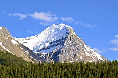 Mount Victoria's north peak seen from the Wapta Lake area


Другой контент может иметь иную лицензию. Перед использованием материалов сайта WikiSort.org внимательно изучите правила лицензирования конкретных элементов наполнения сайта.
WikiSort.org - проект по пересортировке и дополнению контента Википедии