geo.wikisort.org - Mountains
Mount Parrish is a 2,530-metre (8,301-foot) mountain summit located in Alberta, Canada.
| Mount Parrish | |
|---|---|
 Mount Parrish (center), from northeast (Andy Good Peak to left) | |
| Highest point | |
| Elevation | 2,530 m (8,301 ft)[1][2] |
| Prominence | 161 m (528 ft)[1] |
| Parent peak | Chinook Peak (2,591 m)[1] |
| Isolation | 0.73 km (0.45 mi)[1] |
| Listing | Mountains of Alberta |
| Coordinates | 49°34′30″N 114°35′17″W[3] |
| Naming | |
| Etymology | Sherman Parrish |
| Geography | |
Mount Parrish Location of Mount Parrish in Alberta  Mount Parrish Mount Parrish (Canada) | |
| Location | Castle Wildland Provincial Park Alberta, Canada |
| Parent range | Flathead Range[4] Canadian Rockies |
| Topo map | NTS 82G10 Alberta[3] |
| Geology | |
| Mountain type | Fault block |
| Type of rock | Limestone[5] |
| Climbing | |
| Easiest route | class 4+ climbing[5] |
Description
Mount Parrish is situated eight kilometers southwest of the town of Coleman in the Crowsnest Pass area and can be seen from Highway 3, the Crowsnest Highway.[2] It is part of the Flathead Range which is a subset of the Canadian Rockies. The peak is set one kilometer east of the Continental Divide, in Castle Wildland Provincial Park. Precipitation runoff from the mountain drains into tributaries of the nearby Crowsnest River. Topographic relief is significant as the summit rises 1,190 meters (3,900 feet) above the river in 5 kilometers (3.1 miles). Chinook Peak is 2 km (1.2 mi) to the northwest of Mt. Parrish and the nearest higher neighbor is Andy Good Peak, 1 km (0.62 mi) to the south.[1]
History
Mount Parrish is named after Sherman Parrish, an early settler in the Crowsnest Pass area in 1898.[6] He homesteaded at the foot of this mountain and raised cattle. The mountain's toponym was officially adopted March 15, 1962, by the Geographical Names Board of Canada.[3]
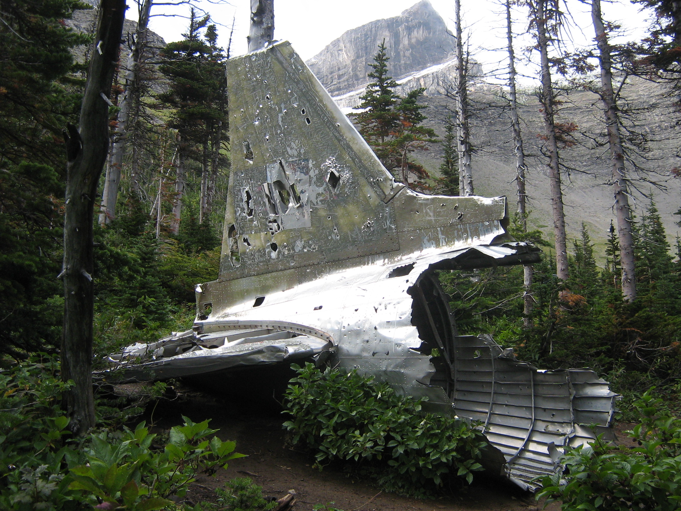
On January 19, 1946, a Royal Canadian Air Force DC-3 struck Mount Ptolemy and crashed into the North York Creek valley below Mount Parrish.[2] All seven crewmembers perished in the accident. Some wreckage of the aircraft is still present.
Geology
Mount Parrish is composed of limestone which is a sedimentary rock laid down during the Precambrian to Jurassic periods. Formed in shallow seas, this sedimentary rock was pushed east and over the top of younger Cretaceous period rock during the Laramide orogeny.[7]
Climate
Based on the Köppen climate classification, Mount Parrish has an alpine subarctic climate with cold, snowy winters, and mild summers.[8] Winter temperatures can drop below −20 °C with wind chill factors below −30 °C.
Gallery
 Mt. McLaren, with Andy Good Peak (behind), and Mt. Parrish (center)
 Mount Parrish (left), Mount McLaren (centered), and Chinook Peak (right)
 Flathead Range
L→Rː Mt. Coulthard, Mt. McLaren, Andy Good Peak, Mt. Parrish, Chinook Peak North aspect
 DC-3 wreckage below Mt. Parrish
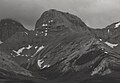 North aspect
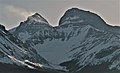 Mount Parrish (right), (Andy Good Peak to left)


See also
- Geology of Alberta
- Geography of Alberta
References
- "Mount Parrish, Peakvisor.com". Retrieved November 3, 2022.
- "Mount Parrish". PeakFinder.com. Retrieved 2022-11-03.
- "Mount Parrish". Geographical Names Data Base. Natural Resources Canada. Retrieved 2022-11-03.
- "Flathead Range". Geographical Names Data Base. Natural Resources Canada. Retrieved 2022-11-02.
- Andrew Nugara (2014), More Scrambles in the Canadian Rockies Second Edition, Rocky Mountain Books, ISBN 9781771600170, p. 176
- Dave Birrell (2000), 50 Roadside Panoramas in the Canadian Rockies, Rocky Mountain Books, ISBN 9780921102656, p. 138
- Gadd, Ben (2008), Geology of the Rocky Mountains and Columbias
- Peel, M. C.; Finlayson, B. L.; McMahon, T. A. (2007). "Updated world map of the Köppen−Geiger climate classification". Hydrol. Earth Syst. Sci. 11: 1633–1644. ISSN 1027-5606.
External links
- Mount Parrish: weather forecast
Другой контент может иметь иную лицензию. Перед использованием материалов сайта WikiSort.org внимательно изучите правила лицензирования конкретных элементов наполнения сайта.
WikiSort.org - проект по пересортировке и дополнению контента Википедии