geo.wikisort.org - Mountains
Andy Good Peak is located on the Canadian provincial boundary between Alberta and British Columbia on the Continental Divide. It was named in 1916 after Andy Good, a hotel owner in nearby Crowsnest Pass whose bar straddled the provincial border.[1][2][4]
| Andy Good Peak | |
|---|---|
Andy Good Peak Location in Alberta and British Columbia | |
| Highest point | |
| Elevation | 2,662 m (8,734 ft)[1] |
| Prominence | 262 m (860 ft)[2] |
| Parent peak | Mount Ptolemy[2] |
| Listing | Mountains of Alberta |
| Coordinates | 49°33′55″N 114°35′17″W[3] |
| Geography | |
| Country | Canada |
| Provinces | Alberta and British Columbia |
| District | Kootenay Land District |
| Parent range | Flathead Range |
| Topo map | NTS 82G10 Alberta |
See also
- List of peaks on the British Columbia–Alberta border
- Mountains of British Columbia
Gallery
 Mt. McLaren, with Andy Good Peak (behind), and Mt. Parrish (right)
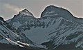 Andy Good Peak left, Mount Parrish right
 Flathead Range
Left to rightː Mount Coulthard, Andy Good Peak, Mount Parrish, Chinook Peak.


References
- "Andy Good Peak". PeakFinder.com. Retrieved 2010-02-18.
- "Andy Good Peak". Bivouac.com. Retrieved 2010-02-18.
- "Andy Good Peak". BC Geographical Names. Retrieved 2013-06-08.
- Boles, Glen W.; Laurilla, Roger W.; Putnam, William L. (2006). Canadian Mountain Place Names. Vancouver: Rocky Mountain Books. pp. 28. ISBN 978-1-894765-79-4.
This Alberta's Rockies location article is a stub. You can help Wikipedia by expanding it. |
This article about a location in British Columbia, Canada is a stub. You can help Wikipedia by expanding it. |
Текст в блоке "Читать" взят с сайта "Википедия" и доступен по лицензии Creative Commons Attribution-ShareAlike; в отдельных случаях могут действовать дополнительные условия.
Другой контент может иметь иную лицензию. Перед использованием материалов сайта WikiSort.org внимательно изучите правила лицензирования конкретных элементов наполнения сайта.
Другой контент может иметь иную лицензию. Перед использованием материалов сайта WikiSort.org внимательно изучите правила лицензирования конкретных элементов наполнения сайта.
2019-2026
WikiSort.org - проект по пересортировке и дополнению контента Википедии
WikiSort.org - проект по пересортировке и дополнению контента Википедии