geo.wikisort.org - Mountains
Dajti (Albanian: Mali i Dajtit) standing at 1,613 m (5,292 ft) above sea level, is a mountain and national park on the edge of Tirana, Albania. The Dajti belongs to the Skanderbeg range. In winter, the mountain is often covered with snow and is a popular retreat for the local population of Tirana, which rarely sees snowfall. Its slopes have forests of pines, oak and beech, while its interior contains canyons, waterfalls, caves, a lake, and an ancient castle.
This article uses bare URLs, which are uninformative and vulnerable to link rot. (September 2022) |
| Dajti | |
|---|---|
 Dajt as seen from the east. | |
| Highest point | |
| Elevation | 1,613 m (5,292 ft) |
| Coordinates | 41°21′57″N 19°55′32″E |
| Geography | |
 Dajti Location in Albania | |
| Location | Tirana, Albania |
| Parent range | Skanderbeg Mountains |
| Geology | |
| Age of rock | Triassic |
| Mountain type | Karst[1] |
| Climbing | |
| Easiest route | SH54 |
 | |
Protected area
Dajti National Park was declared a national park in 1966, and has an expanded area of about 29,384 hectares since 2006.[2] The area is under shared jurisdiction between Albanian Agency of Protected Areas (AKZM) and Tirana Municipality Parks and Recreation Agency (APR). In 2019, the new Dajti Mt National Park tourist information centre was opened located near the TV and Radio towers along SH47 road in Fushe Dajt.[3]

The mountain can be reached through a narrow asphalted mountain road onto an area known as Fusha e Dajtit. This was the location of a summer camp but now is the site of many restaurants and radio and TV transmitters. From this small area there is an excellent view of Tirana and its plain. This is the reason this place has been named as the Balcony of Tirana.
As of June 2005 hikers and visitors to the mountain can use an Austrian built gondola lift from the eastern outskirts of Tirana to Fusha e Dajtit (Plain of Dajti) at 1050 meters altitude.[4] There are several radio and TV transmitters at the summit of the mountain.
Traces of prehistoric settlements and fortifications from later periods have been discovered in the area.
Environmental issues

A serious environmental problem on the mountain is how to deal with garbage. This is partially caused by restaurants and hotels that leave rubbish everywhere since there are few garbage bins in the region.[citation needed]
Another major problem on the mountain is deforestation. In the summer of 2012, 10 ha of forests were burned at the Priska summit.[5] Forest fires are happening yearly while those responsible are not being convicted. Responsibilities lie with the Ministry of the Environment, Municipality of Tirana, foresters (rangers) and the people who live in the area.
Water pollution of the lake and air pollution caused by cars crossing the mountain roads are also problematic.
See also
- Geography of Albania
- Mountains of Albania
- Dajti National Park
- Dajti Castle
Gallery
 Tirana from the Big Park with Mount Dajt in the background
 The peak of the Mountain
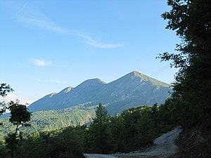 Seen from the east
 Dajti Mountain seen from central Tirana
 Tirana seen from Dajti


References
- "Facing environmental problems in karst areas of developing countries: the case study of Dajti - Mali me Gropa (Albania)" (PDF). meetings.copernicus.org. p. 1.
- "Archived copy" (PDF). Archived from the original (PDF) on 2016-03-04. Retrieved 2014-12-07.
{{cite web}}: CS1 maint: archived copy as title (link) - "Inaugurohet qendra e re e vizitorëve në Parkun Kombëtar të Dajtit - ATSH -". 25 March 2019.
- "Dajti Ekspres". Dajti Ekspres. Retrieved 21 December 2017.
- http://gazeta-shqip.com/lajme/2012/08/16/zjarret-ne-dajt/
| |||||||||||||||||||||||||||||||||||||||||
На других языках
[de] Dajti
Der Dajti (albanisch Mali i Dajtit, auch Dajt) ist ein Berg in Mittelalbanien mit einer Höhe von 1613 m ü. A. Er ist der Hausberg der albanischen Hauptstadt Tirana, in deren Osten er sich erhebt. Das Gebiet des Berges steht als Nationalpark Dajti unter Schutz.- [en] Dajti
[es] Monte Dajt
El monte Dajt (albanés, Dajt o Dajti) es una montaña en el centro de Albania, al este de Tirana. Su pico más alto se encuentra a 1613 msnm. En invierno, la montaña está cubierta de nieve, y es un lugar popular de ocio para la población local de Tirana, que raramente ve caer la nieve. En sus laderas hay pinos, robles y hayas.[fr] Mont Dajti
Le mont Dajti est une montagne qui s’élève à 1 613 m d’altitude à l'est de Tirana, en Albanie.[it] Monte Dajt
Il Monte Dajt (in albanese: Mali i Dajtit) è una montagna dell'Albania centrale a est di Tirana. È raggiungibile dalla capitale tramite una funivia lunga 4,5 km (la Dajti Ekspres), la più lunga dei Balcani.[ru] Дайти (гора)
Дайти[2][3] (алб. Dajti) — гора в центре Албании, на восток от столицы страны Тираны. Высота горы 1610 м над уровнем моря[2][3]. Зимой, когда вершина покрывается снегом, гора становится популярным местом для жителей Тираны, которые редко видят снегопад.Другой контент может иметь иную лицензию. Перед использованием материалов сайта WikiSort.org внимательно изучите правила лицензирования конкретных элементов наполнения сайта.
WikiSort.org - проект по пересортировке и дополнению контента Википедии