geo.wikisort.org - River
The Suwannee River (also spelled Suwanee River) is a river that runs through south Georgia southward into Florida in the southern United States. It is a wild blackwater river, about 246 miles (396 km) long.[1] The Suwannee River is the site of the prehistoric Suwanee Straits which separated peninsular Florida from the panhandle.
This article needs additional citations for verification. (December 2019) |
| Suwannee | |
|---|---|
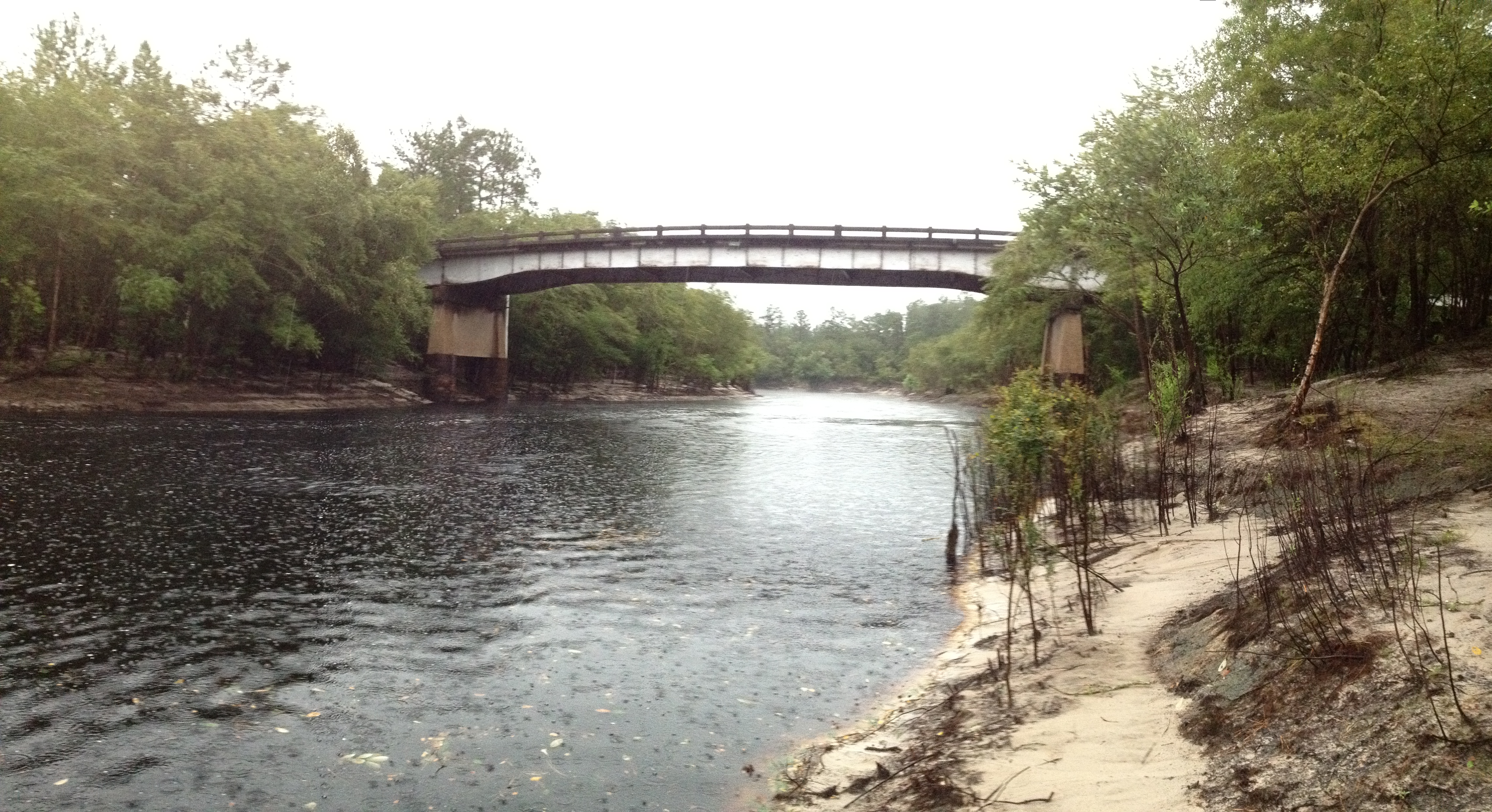
 The Suwannee River near Lake City, Florida | |
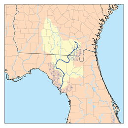 Suwannee River Drainage Basin | |
| Location | |
| Country | United States |
| , Georgia (U.S. state), Florida | |
| Cities | Fargo, Georgia, White Springs, Florida, Branford, Florida |
| Physical characteristics | |
| Source | Okefenokee National Wildlife Refuge |
| • location | Fargo, Georgia |
| Mouth | Gulf of Mexico |
• location | Lower Suwannee National Wildlife Refuge, Suwannee, Florida |
• coordinates | 29°17′18″N 83°9′57″W |
• elevation | 0 ft (0 m) |
| Length | 246 mi (396 km) |
| Discharge | |
| • location | Gulf of Mexico |
| Basin features | |
| Tributaries | |
| • left | Santa Fe River |
| • right | Alapaha River, Withlacoochee River |
Geography
The headwaters of the Suwannee River are in the Okefenokee Swamp in the town of Fargo, Georgia. The river runs southwestward into the Florida Panhandle, then drops in elevation through limestone layers into a rare Florida whitewater rapid. Past the rapid, the Suwanee turns west near the town of White Springs, Florida, then connects to the confluences of the Alapaha River and Withlacoochee River.
Starting at the confluences of those three rivers, that confluence forms the southern borderline of Hamilton County, Florida. The Suwanee then bends southward near the town of Ellaville, Florida, followed by Luraville, Florida, then joins together with the Santa Fe River (Florida) from the east, south of the town of Branford, Florida.
The river ends and drains into the Gulf of Mexico on the outskirts of Suwannee, Florida.
Etymology
The Spanish recorded the native Timucua name of Guacara for the river that would later become known as the Suwannee. Different etymologies have been suggested for the modern name.
- San Juan: D.G. Brinton first suggested in his 1859 Notes on the Floridian Peninsula that Suwannee was a corruption of the Spanish San Juan.[2] This theory is supported by Jerald Milanich, who states that "Suwannee" developed through "San Juan-ee" from the 17th-century Spanish mission of San Juan de Guacara, located on the Suwannee River.[3]
- Shawnee: The migrations of the Shawnee (Shawnee: Shaawanwaki; Muscogee: Sawanoke) throughout the South have also been connected to the name Suwannee. As early as 1820, the Indian agent John Johnson said "the 'Suwaney' river was doubtless named after the Shawanoese [Shawnee], Suwaney being a corruption of Shawanoese."[4] However, the primary southern Shawnee settlements were along the Savannah River, with only the village of Ephippeck on the Apalachicola River being securely identified in Florida, casting doubt on this etymology.
- "Echo": In 1884, Albert S. Gatschet claimed that Suwannee derives from the Creek word sawani, meaning "echo", rejecting the earlier Shawnee theory.[5] Stephen Boyd's 1885 Indian Local Names with Their Interpretation [6] and Henry Gannett's 1905 work The Origin of Certain Place Names in the United States repeat this interpretation, calling sawani an "Indian word" for "echo river".[7] Gatschet's etymology also survives in more recent publications, often mistaking the language of translation. For example, a University of South Florida website states that the "Timucuan Indian word Suwani means Echo River ... River of Reeds, Deep Water, or Crooked Black Water".[8] In 2004, William Bright repeats it again, now attributing the name "Suwanee" to a Cherokee village of Sawani, which is unlikely as the Cherokee never lived in Florida or south Georgia.[9] This etymology is now considered doubtful: 2004's A Dictionary of Creek Muscogee does not include the river as a place-name derived from Muscogee, and also lacks entries for "echo" and for words such as svwane, sawane, or svwvne, which would correspond to the anglicization "Suwannee".[10]
History

The Suwannee River area has been inhabited by humans for thousands of years. During the first millennium it was inhabited by the people of the Weedon Island culture, and around the year 900 a derivative local culture known as the Suwanee River Valley culture developed.
By the 16th century, the river was inhabited by two closely related Timuca-speaking peoples: the Yustaga, who lived on the west side of the river; and the Northern Utina, who lived on the east side.[11] By 1633, the Spanish had established the missions of San Juan de Guacara, San Francisco de Chuaquin, and San Augustin de Urihica along the Suwannee to convert these western Timucua peoples.[12]
In the 18th century, Seminoles lived by the river.
The steamboat Madison operated on the river before the Civil War, and the sulphur springs at White Springs became popular as a health resort, with 14 hotels in operation in the late 19th century.
Recreation

According to the U.S. Fish & Wildlife Service, "The Lower Suwannee National Wildlife Refuge is unlike other refuges in that it was not established for the protection of a specific species, but in order to protect the high water quality of the historic Suwannee River."[13]
The Suwannee River Wilderness Trail is "a connected web of Florida State Parks, preserves and wilderness areas" that stretches more than 170 miles (274 kilometers), from Stephen Foster Folk Culture Center State Park to the Gulf of Mexico.[14]
The Lower Suwannee National Wildlife Refuge offers bird and wildlife observation,[15] wildlife photography, fishing, canoeing, hunting, and interpretive walks.[16] Facilities include foot trails, boardwalks, paddling trails, wildlife drives, archaeological sites, observation decks and fishing piers.[13]
Crossings
| Image | Crossing | Carries | Location | Opened | Closed | ID number | Coordinates |
|---|---|---|---|---|---|---|---|
Georgia | |||||||
| Suwannee River Sill | Okefenokee National Wildlife Refuge | 30.803778°N 82.417672°W | |||||
| Norfolk Southern Railway (Former Atlantic, Valdosta and Western Railway line) |
Fargo | 30.683964°N 82.559503°W | |||||
| Edith to Fargo | 1952 | 30.680902°N 82.559930°W | |||||
Florida | |||||||
| Turner Bridge (defunct) | Northeast 38th Trail | Cypress Creek Conservation Area | late 1950s | 30.524596°N 82.727892°W | |||
 |
Bay Creek Conservation Area | 1951 | 290027 | 30.507345°N 82.716491°W | |||
| Cone Bridge (defunct) | Cone Bridge Road | late 1960s | 30.444933°N 82.671049°W | ||||
| Godwin Bridge (defunct) | Godwin Bridge Road | late 1950s | 30.350554°N 82.685593°W | ||||
 |
Norfolk Southern Railway (Former Georgia Southern and Florida Railway line) |
White Springs | 30.326129°N 82.738300°W | ||||
 |
Ed Scott Bridge | White Springs | 1980 | 290083 | 30.325815°N 82.738476°W | ||
 |
J. Graham Black-Joseph W. McAlpin Bridge | White Springs | 1954 | 290030 | 30.328156°N 82.759784°W | ||
| 1962, 1997 | 30.346492°N 82.832868°W | ||||||
 |
Suwannee Springs Bridge (closed) | Former US 129 | Suwannee Springs | 1931 | 1974 | 30.395418°N 82.935808°W | |
| Old Suwanee Springs Bridge (defunct) | 91st Drive | Suwannee Springs | 1930s | 30.394699°N 82.934293°W | |||
 |
Suwannee Springs, Florida | 1971 | 320019 | 30.398143°N 82.937750°W | |||
| Former Savannah, Florida & Western Railway line (ACL, SBD, CSXT) | 186? | 1988 | 30.409236°N 82.951814°W | ||||
 |
Nobels Ferry Bridge | 1984 | 320052 | 30.437103°N 83.091613°W | |||
| Old Nobels Ferry Bridge (defunct) | 30.436936°N 83.094566°W | ||||||
 |
CSX Transportation (Former Pensacola and Georgia Railroad line) |
Ellaville | 30.385055°N 83.172333°W | ||||
 |
Hillman Bridge (closed) | Former US 90 | Ellaville | 1926 | 1986 | 30.384711°N 83.174660°W | |
 |
Ellaville | 1986 | 350062 | 30.384719°N 83.175780°W | |||
| Suwannee River State Park | 1971 | 30.357776°N 83.193314°W | |||||
 |
Dowling Park | 1955 | 370018 | 30.244572°N 83.249696°W | |||
 |
Former Live Oak, Perry and Gulf Railroad line | Dowling Park | 1957 | 1977 | 30.243270°N 83.250864°W | ||
 |
Hal W. Adams Bridge | Luraville | 1947 | 330009 | 30.099254°N 83.171785°W | ||
 |
Drew Bridge (closed) | Former Suwannee & San Pedro Railroad line | Mayo | 1901 | 1920 | 30.101030°N 83.114136°W | |
 |
Frank R. Norris Bridge | Branford | 1989 | 29.955173°N 82.929550°W | |||
 |
W. O. Cannon - D. W. McCollister Bridge | 1965 | 310002 | 29.795707°N 82.919843°W | |||
 |
Nature Coast State Trail (Former CSX Transportation line) |
Old Town | 29.608282°N 82.971233°W | ||||
 |
Joe H. Anderson Sr. Bridge | Fanning Springs | 1963 | 300031, 300061 | 29.591323°N 82.937398°W | ||
See also
- List of Florida rivers
- List of Georgia rivers
- South Atlantic-Gulf Water Resource Region
Notes
- U.S. Geological Survey. National Hydrography Dataset high-resolution flowline data. The National Map, accessed April 18, 2011
- Brinton, Daniel; Brinton, Garrison Brinto Daniel Garrison (2016-10-10). Notes on the Floridian Peninsula. Applewood Books. ISBN 9781429022637.
- Milanich:12-13
- Johnson, Byron A. "THE SUWANNEE - SHAWNEE DEBATE" (PDF). Florida Anthropologist. 25 (2, pt. 1, June 1972): 67.
- Gatschet, Albert Samuel (1884-01-01). A Migration Legend of the Creek Indians. D.G. Brinton.
- Boyd, Stephen G. (1885-01-01). Indian Local Names with Their Interpretation. author.
- Gannett, Henry (1905-01-01). The Origin of Certain Place Names in the United States. U.S. Government Printing Office. p. 294.
sawani cherokee.
- "The Suwannee River, Exploring Florida: A Social Studies Resource for Students and Teachers". College of Education, University of South Florida. 2002. Retrieved 2010-08-18.
- Bright, William (2004). Native American placenames of the United States. University of Oklahoma Press. pp. 466–467. ISBN 978-0-8061-3598-4. Retrieved 2011-04-11.
- Martin, Jack B.; Mauldin, Margaret McKane (2004-12-01). A Dictionary of Creek/Muskogee. U of Nebraska Press. ISBN 0803283024.
- Worth vol. I, pp. 28–29.
- Milanich, Jerald T. (1996-08-14). Timucua. VNR AG. ISBN 9781557864888.
- Staff (2015). "Lower Suwannee National Wildlife Refuge: About the Refuge". FWS.gov. U.S. Fish & Wildlife Service. Archived from the original on September 30, 2018. Retrieved 3 December 2019.
- Robin Draper (April 27, 2016). "Authentic Florida: 6 essentials of the Suwannee River". Florida Today. Archived from the original on April 30, 2016. Retrieved 2 December 2019.
- American Bird Conservancy (13 April 2011). The American Bird Conservancy Guide to the 500 Most Important Bird Areas in the: Key Sites for Birds and Birding in All 50 States. Random House Publishing Group. p. 415. ISBN 978-0-307-48138-2.
- Lower Suwannee National Wildlife Refuge. U.S. Fish and Wildlife Service. 2003. p. 9.
References
- Milanich, Jerald T. (2006). Laboring in the Fields of the Lord: Spanish Missions and Southeastern Indians. University Press of Florida. ISBN 0-8130-2966-X
- Worth, John E. (1998). Timucua Chiefdoms of Spanish Florida. Volume 1: Assimilation. University Press of Florida. ISBN 0-8130-1574-X. Retrieved August 18, 2010.
- "Florida Dept. of Transportation, Florida Bridge Information" (PDF).
External links
- USF page with history
- EPA info on Suwannee basin
- Suwannee River Wilderness State Trail
- Info on the Suwannee River and surrounding areas from SRWMD
- Suwanee River Watershed - Florida DEP
- U.S. Geological Survey Geographic Names Information System: Suwannee River
Further reading
- Light, H.M., et al. (2002). Hydrology, vegetation, and soils of riverine and tidal floodplain forests of the lower Suwannee River, Florida, and potential impacts of flow reductions [U.S. Geological Survey Professional Paper 1656A]. Denver: U.S. Department of the Interior, U.S. Geological Survey.
Authority control | |
|---|---|
| General |
|
| National libraries | |
На других языках
[de] Suwannee River
Der Suwannee River (auch Suwanee River oder Swanee River) ist ein Fluss, der durch die US-amerikanischen Bundesstaaten Florida und Georgia fließt. Seine Länge beträgt 426 Kilometer.- [en] Suwannee River
[it] Suwannee (fiume)
Il Suwannee (o anche Suwanee) è un fiume di 396 km[1][2] del sud-est degli Stati Uniti d'America, che scorre tra il sud-est della Georgia e il nord/nord-ovest della Florida: nasce dalla palude di Okefenokee e sfocia nel golfo del Messico.[1]Другой контент может иметь иную лицензию. Перед использованием материалов сайта WikiSort.org внимательно изучите правила лицензирования конкретных элементов наполнения сайта.
WikiSort.org - проект по пересортировке и дополнению контента Википедии