geo.wikisort.org - River
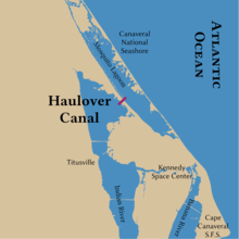
The Haulover Canal is a waterway north of Merritt Island, Florida, near the former site of Allenhurst, that connects Mosquito Lagoon with the Indian River, and is part of the Intracoastal Waterway.
| Haulover Canal | |
|---|---|
 Haulover Canal Bridge | |
 | |
| Location | Brevard County, Florida |
| Country | United States |
| Specifications | |
| Locks | None |
| Status | Open |
| Navigation authority | U.S. Army Corps of Engineers |
| History | |
| Date completed | 1887 |
| Geography | |
| Start point | Mosquito Lagoon |
| End point | Indian River |
In the early 1960s there were plans to relocate the canal further north, near the junction of US 1 and Courtenay Parkway, but by 1964 when the new Haulover Canal Bridge was constructed these plans had been shelved.[1]
Crossings
| Crossing | Carries | Image | Location | Coordinates |
|---|---|---|---|---|
| Haulover Canal Bridge (drawbridge) |
Courtenay Parkway |
Allenhurst | 28°44′11″N 80°45′17″W |
Old Haulover Canal
Old Haulover Canal | |
U.S. National Register of Historic Places | |
 Historic marker, with canal in background | |
  | |
| Location | Brevard County, Florida |
|---|---|
| Nearest city | Merritt Island |
| Coordinates | 28°44′11″N 80°45′17″W |
| NRHP reference No. | 78000262 |
| Added to NRHP | December 19, 1978 |
The Old Haulover Canal is a historic location north of Merritt Island, Florida. On December 19, 1978, it was added to the United States National Register of Historic Places.
According to the state historical marker near the site:
Native Americans, explorers and settlers hauled or carried canoes and small boats over this narrow strip of land between Mosquito Lagoon and the Indian River. Eventually it became known as the "haulover." Connecting both bodies of water had long challenged early settlers of this area. Spaniards visited as early as 1605 and slid boats over the ground covered with mulberry tree bark. Early settlers used rollers and skids to drag schooners across. Fort Ann was established nearby in 1837, during the 2nd Seminole War (1835–1842), to protect the haulover from Indians and carry military supplies from the lagoon to the river. In 1852, contractor G.E. Hawes dug the first canal using slave labor. It was 3 feet (0.91 m) deep, 14 feet (4.3 m) wide, and completed in time for the 3rd Seminole War (1856–1858). Steamboat and cargo ships used the passage until the railroad arrived in 1885. By 1887, the Florida Coast Line Canal and Transportation Company dug a new and deeper canal which you see now, a short distance from the original. The Intracoastal Waterway incorporated the Haulover Canal as a federal project in 1927 to be maintained by the U.S. Army Corps of Engineers. Since then the channel has been dug wider and deeper, and a basin added for launching boats.[2]
References
- "Haulover Bridge Contract Let", Daytona Beach Morning Journal, 3 October 1964
- Brevard County markers
External links
 Media related to Old Haulover Canal at Wikimedia Commons
- Brevard County listings at National Register of Historic Places
- Florida's Office of Cultural and Historical Programs
U.S. National Register of Historic Places in Florida | ||
|---|---|---|
| Lists by county |
|  |
| Lists by city |
| |
| Other lists |
| |
| ||
Другой контент может иметь иную лицензию. Перед использованием материалов сайта WikiSort.org внимательно изучите правила лицензирования конкретных элементов наполнения сайта.
WikiSort.org - проект по пересортировке и дополнению контента Википедии