geo.wikisort.org - River
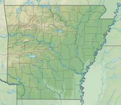
The Sulphur River is a 175-mile-long (282 km)[2] river in northeast Texas and southwest Arkansas in the United States.
| Sulphur River | |
|---|---|
 Location of mouth | |
| Location | |
| Country | United States |
| States | Texas, Arkansas |
| Physical characteristics | |
| Source | |
| • location | Confluence of north and south forks at |
| • coordinates | 33°23′36″N 95°21′20″W[1] |
| • elevation | 101 meters (331 ft) |
| Mouth | |
• location | Red River at |
• coordinates | 33°05′36″N 93°51′42″W[1] |
• elevation | 58 meters (190 ft)[1] |
| Length | 175 miles (282 km) |
Geography
The Sulphur River begins at the confluence of its north and south forks forming (following earlier meanders) the northern and southern boundaries of, and meeting at the eastern end of, Delta County (Texas).[3] This is about 4.7 miles (7.6 km) northeast of the town of Sulphur Bluff, 95 miles (153 km) northeast of Dallas, and 16 miles (26 km) downstream (air miles) along the south fork from the Cooper Lake dam.
The river flows generally eastward through several Texas counties and provides most of the water for Wright Patman Lake, on the border between Bowie and Cass counties. Below Wright Patman Dam, the river continues its generally eastward flow to the Arkansas state line. The river flows southeastward through Miller County in southwestern Arkansas for 15 miles (24 km) until it joins the southbound Red River east of Doddridge, a few miles north of the Louisiana border.
Recreation
The Sulphur River provides numerous opportunities for fishing, boating, and other activities.
Above Wright Patman Lake, the river has enough water for recreation most of the time. The flow is slow, and the river is murky, largely due to channelization upstream. Below Wright Patman Dam, the river flow depends on the amount of water being released from the dam; however, water quality is usually good.
Wright Patman Lake provides additional opportunities for camping, boating, swimming, and fishing.[4]
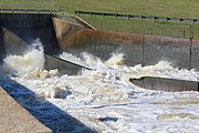 The spillway at Lake Wright Patman during the flood of 2015-2016. After this the Sulphur river flows into Miller county, Arkansas.
 The control center for the Lake Wright Patman dam gates. After this the Sulphur river flows into Miller county, Arkansas.
 This is a brass survey marker for the Lake Wright Patman Dam installed in 1981 by the U.S. Army Corp of Engineers


See also
References
- U.S. Geological Survey Geographic Names Information System: Sulphur River
- "The National Map". U.S. Geological Survey. Retrieved March 8, 2011.
- National Map (Map). USGS. Retrieved 15 Jan 2022.
- "Wright Patman Dam and Lake". US Army Corps of Engineers. Retrieved 15 Jan 2022.
External links
- Sulphur River Basin Authority
- Texas Parks and Wildlife Department: An Analysis of Texas Waterways
- Sulphur River from the Handbook of Texas Online
| Authority control: National libraries |
|---|
Другой контент может иметь иную лицензию. Перед использованием материалов сайта WikiSort.org внимательно изучите правила лицензирования конкретных элементов наполнения сайта.
WikiSort.org - проект по пересортировке и дополнению контента Википедии