geo.wikisort.org - River
The Gulf Intracoastal Waterway is the portion of the Intracoastal Waterway located along the Gulf Coast of the United States. It is a navigable inland waterway running approximately 1,050 mi (1,690 km) from Carrabelle, Florida, to Brownsville, Texas.
| Gulf Intracoastal Waterway | |
|---|---|
 Leland Bowman Lock near Intracoastal City, Louisiana, on the Gulf Intracoastal Waterway | |
 The route of the Gulf Intracoastal Waterway | |
| Location | Gulf Coast of the United States |
| Country | United States |
| Specifications | |
| Length | 1,050 miles (1,690 km) |
| History | |
| Date completed | June 18, 1949 |
| Geography | |
| Start point | Brownsville, Texas |
| End point | Carrabelle, Florida |
| Branch of | Intracoastal Waterway |
| Connects to | Various |
The waterway provides a channel with a controlling depth of 12 ft (3.7 m), designed primarily for barge transportation. Although the U.S. government proposals for such a waterway were made in the early 19th century,[1] the Gulf Intracoastal Waterway was not completed until 1949.[2]
EHL & WHL mileages
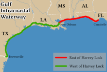
Locations along the Gulf Intracoastal Waterway are defined in terms of statute miles (as opposed to nautical miles, in which most marine routes are measured) east and west of Harvey Lock, a navigation lock in the New Orleans area located at 29.909°N 90.084°W. The Hathaway Bridge in Panama City, Florida, for example, is at mile 284.6 EHL (East of Harvey Lock). The Queen Isabella Causeway Bridge at South Padre Island is at mile 665.1 WHL (West of Harvey Lock).[3]
Connecting waterways
The Gulf Intracoastal Waterway crosses or meets, and in some cases is confluent with, numerous other navigable rivers and waterways. They include:
- Apalachicola River
- Arroyo Colorado
- Atchafalaya River
- Bayou Lafourche
- Bayou Terrebonne
- Calcasieu River
- Calcasieu Ship Channel
- Delcambre Canal
- Houston Ship Channel
- Industrial Canal
- Lower Mississippi River
- Mississippi River-Gulf Outlet Canal
- Mobile Bay (connecting to the Tenn-Tom Waterway)
- Pearl River
- Sabine-Neches Waterway (Includes portions of)
- Santa Rosa Sound
- The Rigolets
- Vermilion River
Ports and harbors
Many of the busiest ports in the United States in terms of tons of cargo[4] are located on or near the Gulf Intracoastal Waterway. Notable ports on or near the waterway include:
Florida
- Apalachicola, Florida
- Carrabelle, Florida
- Panama City, Florida
- Pensacola, Florida
Alabama
- Mobile, Alabama - Ranked 11th busiest
Mississippi
- Gulfport, Mississippi
- Pascagoula, Mississippi - Ranked 29th busiest
Louisiana
- Baton Rouge, Louisiana - Ranked 7th busiest
- Houma, Louisiana -
- Intracoastal City, Louisiana
- Lake Charles, Louisiana - Ranked 14th busiest
- Larose, Louisiana
- Morgan City, Louisiana
- New Orleans, Louisiana - Ranked 5th busiest
- Port Allen, Louisiana
- Port of South Louisiana - Ranked 2nd busiest
- Port of Plaquemines - Ranked 12th busiest
Texas
- Beaumont, Texas - Ranked 8th busiest
- Brownsville, Texas
- Corpus Christi, Texas - Ranked 3rd busiest
- Port Freeport, Texas - Ranked 16th busiest
- Galveston, Texas - Ranked 46th busiest
- Houston, Texas - Ranked as busiest port in the United States
- Port Arthur, Texas - Ranked 15th busiest
- Port Lavaca - Point Comfort, Texas
- Texas City, Texas - Ranked 20th busiest
- Victoria, Texas
See also
- IHNC Lake Borgne Surge Barrier
- Gulf Intracoastal Waterway West Closure Complex
References
- Leatherwood, Art (15 June 2010). "Gulf Intracoastal Waterway". Handbook of Texas Online. Texas State Historical Association. Retrieved March 23, 2020.
- Lynn M. Alperin. "History of the Gulf Intracoastal Waterway" (PDF). U.S. Army Corps of Engineers Office of History. Archived from the original (PDF) on 2005-12-08. Retrieved 2006-04-03.
- "33 CFR 89.25 Waters Specified by the Secretary" (PDF). U.S. Coast Guard Navigation Center. Retrieved 2006-04-21.
- "Tonnage of Top 50 U.S. Water Ports, Ranked by Total Tons". U.S. Bureau of Transportation Statistics. Retrieved 2022-10-14.
На других языках
[de] Gulf Intracoastal Waterway
Der Gulf Intracoastal Waterway (GIWW) ist eine Wasserstraße im Süden der Vereinigten Staaten und erstreckt sich entlang der Küste des Golf von Mexiko von Brownsville in Texas bis nach Fort Myers an der Westküste von Florida. Er bildet zusammen mit dem Atlantic Intracoastal Waterway, der von Florida bis nach Boston in Massachusetts reicht, den Intracoastal Waterway.- [en] Gulf Intracoastal Waterway
Другой контент может иметь иную лицензию. Перед использованием материалов сайта WikiSort.org внимательно изучите правила лицензирования конкретных элементов наполнения сайта.
WikiSort.org - проект по пересортировке и дополнению контента Википедии