geo.wikisort.org - Reservoir
Lake Tawakoni (/təˈwɑːkəni/ tə-WAH-kə-nee) is a 37,879-acre (15,329 ha) reservoir located in Northeast Texas, about 48 miles (77 km) east of Dallas. It lies within three Texas counties, Hunt, Rains, and Van Zandt. It is used for water supply and recreation. It is under the Sabine River Authority of Texas and the original headwaters of the Sabine are converged under the lake surface.
| Lake Tawakoni | |
|---|---|
 Sunset over Duck Cove | |
 Lake Tawakoni  Lake Tawakoni | |
| Location | Hunt / Rains / Van Zandt Counties, Texas |
| Coordinates | 32°50′45″N 95°56′36″W |
| Type | reservoir |
| Basin countries | United States |
| Managing agency | Sabine River Authority of Texas |
| First flooded | October 1960 |
| Surface area | 37,879 acres (15,329 ha) |
| Water volume | 926,000 acre⋅ft (1.142×10⁹ m3) |
| Shore length1 | 200 mi (320 km) |
| Surface elevation | 437.5 ft (133.4 m) |
| References | [1] |
| 1 Shore length is not a well-defined measure. | |
Etymology
The lake was named for the Tawakoni Native American peoples, who were a larger part of the Caddo Nation. The Caddos inhabited a large swath of North and East Texas, including where the lake is located.
History
The reservoir was constructed in 1960 with the Iron Bridge Dam.[2] The area was chosen due to its location to the growing Dallas area and the growth east of the city and its respective suburbs. The South Fork, Cowleech Fork, and Caddo Forks that all formed the Sabine River headwaters are now submerged under the lake and the lake now serves as the headwaters of the Sabine. It covers 37,879 acres (15,329 ha) and has a storage capacity of 926,000 acre-feet (1.142×10⁹ m3) at conservation pool level.[2] It is owned by the Sabine River Authority of Texas.
Flora and fauna
The lake has a diverse array of wildlife. It features deer, feral hogs, snakes, raccoons, bobcats, and over 200 species of birds. Sightings of the American alligator in certain areas of the lake have not been uncommon. The lake mainly has post oak hardwood timber and plants native to the Texas Blackland Prairies. In the summer of 2007, Lake Tawakoni State Park was the site of a large, rare spider web. The web stretched over a 200-yard path and attracted considerable attention from entomologists.[3]
Gallery
 As viewed from West Tawakoni City Park in West Tawakoni, Texas
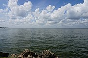 As viewed from East Tawakoni, Texas
 The 200-yard (180 m) spider web found in Lake Tawakoni State Park
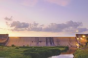 Lake Tawakoni Iron Bridge Dam in East Texas


References
- "Lake Tawakoni". Geographic Names Information System. United States Geological Survey, United States Department of the Interior. 30 November 1979. Retrieved 27 July 2018.
- "Iron Bridge Project". Retrieved June 2, 2015.
- Monster spider web spun in Texas at the Wayback Machine (archive index)
External links

| Authority control |
|
|---|
На других языках
- [en] Lake Tawakoni
[fr] Lac Tawakoni
Le lac Tawakoni est un lac de barrage situé sur le cours de la Sabine, dans les comtés de Hunt, Rains et Van Zandt, dans l’État du Texas, aux États-Unis.Другой контент может иметь иную лицензию. Перед использованием материалов сайта WikiSort.org внимательно изучите правила лицензирования конкретных элементов наполнения сайта.
WikiSort.org - проект по пересортировке и дополнению контента Википедии