geo.wikisort.org - River
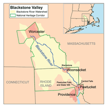
The Blackstone River is a river in the U.S. states of Massachusetts and Rhode Island. It flows approximately 48 mi (80 km) and drains a watershed of approximately 540 sq. mi (1,400 km2). Its long history of industrial use has left a legacy of pollution, and it was characterized by the United States Environmental Protection Agency in 1990 as "the most polluted river in the country with respect to toxic sediments."[1]
| Blackstone River | |
|---|---|
 The Blackstone River in Rhode Island | |
 | |
| Location | |
| Country | United States |
| State | Massachusetts, Rhode Island |
| Region | New England |
| Physical characteristics | |
| Source | |
| • location | Worcester, MA |
| Mouth | |
• location | Seekonk River, at Pawtucket Falls in Pawtucket, Rhode Island |
• coordinates | 41.8771°N 71.3822°W |
| Length | 48 mi (77 km) |
| Basin size | 540 sq mi (1,400 km2) |
History
The river is named after William Blackstone (original spelling William Blaxton) who arrived in Weymouth, Massachusetts in 1623, and became the first European settler of present-day Boston in 1625. He relocated again, to Rhode Island in 1635 and built his home on the river, in what would become Cumberland. With the Providence River, the Blackstone was the northeastern border of Dutch claims for New Netherland from Adriaen Block's charting of Narragansett Bay in 1614 through the Hartford Treaty of 1650.
The original Native American name for the river was the "Kittacuck", which meant "the great tidal river". The "Kittacuck", or Blackstone, was plentiful with salmon and lamprey in pre-colonial and colonial times.[2]

In 1790, Samuel Slater opened the first successful water powered cotton mill in America, Slater Mill, at Pawtucket Falls. This mill was powered by the waters of the Blackstone River. Many other mills appeared along the Blackstone River over time making it an important part of American industry. The industrialization also led to the river being identified by the end of the 20th century as the primary source of Narragansett Bay pollution.[3]
In August 1955, severe flooding on the Blackstone caused extensive damage to Woonsocket, Rhode Island. Where the river is usually 70 feet (21 m) wide it swelled to over 1 mile (1.6 km) wide.[citation needed] The flooding of the Blackstone was the result of a succession of dam breaks and was caused by rainfall from Hurricane Connie followed a week later by Hurricane Diane, which together deposited over 20 inches (510 mm) of rain in parts of Rhode Island and Massachusetts.[4] The Blackstone river reached a stage of 21.8 feet (6.6 m) in Woonsocket, which remains the flood of record; flood stage is 9.0 feet (2.7 m).[5]
The river, together with the Woonasquatucket River to the south, was designated an American Heritage River in 1998.
Course
The river is formed in Worcester, Massachusetts by the confluence of the Middle River and Mill Brook. From there, it follows a rough southeast course through Millbury, Sutton, Grafton, Northbridge, Uxbridge, Millville, and Blackstone. It then continues into Rhode Island, where it flows through Woonsocket, Cumberland, Lincoln, Central Falls, and Pawtucket, where the river then reaches Pawtucket Falls. After that, the river becomes tidal, and flows into the Seekonk River just north of Providence. Other tributaries join the Blackstone along the way, such as the West and Mumford River, at Uxbridge, and the Branch River in North Smithfield.
Pollution and remediation efforts
The Blackstone River has a long association with industry, and a legacy of pollution as a result. By 1900 the river was already considered polluted and the Massachusetts Department of Public Health said in a report, "The Department finds that the condition of the Blackstone River is offensive throughout its course, from Worcester to the state line at Blackstone. The condition of the stream is likely to grow worse until effective measures are completed for removing from the river much of the pollution which it now receives."[6] In 1965, the Water Resources Planning Act created the Water Resources Council Commission and seven river basin commissions. Earth Day 1970 made an impact across the nation. It really was a watershed moment. There were ecology group leaders in the Blackstone River Valley already organized and were springing into action in their local areas. By 1971, a formalized plea for action to the Governor of Rhode Island was made in writing and subsequently in an historic meeting at Old Slater Mill in December 1971. Political support was pledged and in the next few months, the plan discussed that day was followed through by one of the leading organizations, BRWA, that was unique because it served communities from Worcester, MA to Providence, RI along the entirety of the river from the headwaters down to the Narragansett Bay. The executive director of the Blackstone River Watershed Association was David M. Rosser. In April 1972 momentum was building and support was increasingly widespread. What was urgently needed at that time in Spring 1972 was a bullhorn to increase public awareness of the plan for a massive river cleanup. The Providence Journal promotions director, Leighton Authier, was all in after he read through Rosser's very clear and specific action plan. It was not only a plan for the here and now in summer of 1972, but it was a vision for the future of the Blackstone River. That moment in time is known as "Operation ZAP" or also known as "Project ZAP" which was what the newspaper called it. You can see the story of what was ZAP Day on September 9, 1972 in a documentary film entitled, "Operation ZAP" produced in 1974 by a Boston University professor of Communications. Today people say, "Zap the Blackstone," and that is harkening back to what happened- what was begun - back on ZAP Day. That was the beginning of a culture shift in the Blackstone Valley when the communities interested, organized, and resolved to cleanup the their river. Congressman St Germain is known to have said and it's documented in the Congressional Record, "ZAP is an example for the nation." Soon after ZAP, the 1972 Clean Water Act (CWA) sealed the fate of industrial river polluters who had been polluting, abusing, and neglecting this river since 1791. The CWA supported this eagerness in the community to keep up the good work to clean up the river and to hold accountable the industrial culprits, including municipalities who had not yet created sufficient sewerage infrastructure. In 1990, the United States Environmental Protection Agency called the Blackstone, "The most polluted river in the country with respect to toxic sediments."[1]
Early industries discharged a variety of pollutants into the river including dyes from textile mills and heavy metals and solvents from metal and woodworking industries.[6] Much of this early pollution lies trapped in sediments behind historic dams on the river and continues to affect the ecosystem today. Much recent pollution can be traced to the Upper Blackstone Water Pollution Abatement District (UBWPAD),[7] the wastewater treatment plant for Worcester, Massachusetts and surrounding communities, which discharges into the Blackstone. A 2005 report written by the Rhode Island Department of Environmental Management said, "...[the] UBWPAD, North Attleboro, and Attleboro WWTFs play a significant role in the ability to improve water quality in the Providence and Seekonk River system [into which the Blackstone discharges], and efforts to reduce their nitrogen inputs should be initiated as soon as possible."[8] In September 2010, the Conservation Law Foundation, citing this report, filed a lawsuit claiming that the discharge permit issued to the UBWPAD by the Environmental Protection Agency is not "sufficient to meet state water quality standards".[9]
River cleanup is still underway, and today the Blackstone is considered a Class C river (suitable only for "secondary contact" activities like boating) for much of its length.[10]
Crossings

Below is a list of all crossings over the Blackstone River. The list starts at the headwaters and goes downstream.
- Worcester
- Millbury Street
- Massachusetts State Route 122A/146 (Twice)
- Millbury
- Southwest Cutoff (U.S. 20)
- Access Road
- Interstate 90
- Main Street
- Massachusetts State Route 146
- MA 146 Ramp to Main Street
- Waters Street
- Elm Street
- South Main Street
- Providence Street (MA 122A)
- Riverlin Street
- Sutton
- Blackstone Street
- Depot Street
- Grafton
- Pleasant Street
- Main Street (MA 122A)
- Depot Street
- Northbridge
- Sutton Street
- Providence Road (MA 122)
- Elston Avenue
- Church Street Extension
- Uxbridge
- East Hartford Avenue
- Mendon Street (MA 16)
- Millville Road (MA 122)
- Millville
- Central Street
- Cam's Street
- Blackstone
- Bridge Street
- St. Paul Street
- Woonsocket
- Singleton Street
- River Street
- Fairmount Street
- Sayles Street
- South Main Street (RI 104)
- Bernon Street
- Court Street (RI 122)
- Hamlet Avenue (RI 122/126)
- Rhode Island State Route 99
- Cumberland
- Manville Hill Road
- School Street
- Interstate 295
- George Washington Highway (RI 116)
- Blackstone River Bikeway
- Martin Street
- Lonsdale Avenue (RI 122)
- John Street (RI 123)
- Central Falls
- Broad Street (RI 114)
- Roosevelt Avenue
- Cross Street
- Pawtucket
- Exchange Street (RI 15/114 Southbound)
Tributaries
In addition to many unnamed tributaries, the following brooks and rivers feed the Blackstone:
- Worcester Aqueduct
- Dorothy Brook
- Cronin Brook
- Quinsigamond River
- Mumford River
- West River
- Still Corner Brook
- Emerson Brook
- Bacon Brook
- Aldrich Brook
- Ironstone Brook
- Branch River
- Fox Brook
- Cherry Brook
- Mill River
- Peters River
- Crookfall Brook
- West Sneech Brook
- Monastery Brook
- Abbott Run
See also
- Blackstone River Valley National Historical Park
- Blackstone River and Canal Heritage State Park
- Blackstone Valley
- List of rivers in Massachusetts
- List of rivers in Rhode Island
- Seekonk River
- Ten Mile River (Seekonk River)
- Woonasquatucket River
- William Blaxton
Citations
- "Blackstone River Watershed". Rhode Island Rivers Council. Archived from the original on 2012-03-16. Retrieved 2010-12-28.
- source document: Metcalf, Annals of the History of Mendon, 1880.
- Blackstone River Watershed – Five-Year Watershed Action Plan, First Draft Archived March 3, 2007, at the Wayback Machine
- "The Floods of Hurricane Connie and Diane". National Weather Service. Archived from the original on 2012-03-21. Retrieved 2011-02-23.
- "Blackstone River Hydrograph". National Weather Service - Advanced Hydrologic Prediction Service. Archived from the original on 2011-07-21. Retrieved 2011-02-23.
- Kerr, Meg (1990). "Rhode Island Sea Grant Fact Sheet: The Blackstone River". Archived from the original on 2010-06-12. Retrieved 2010-12-29.
- Upper Blackstone Water Pollution Abatement District (UBWPAD)
- "Plan for Managing Nutrient Loadings to Rhode Island Waters" (PDF). Rhode Island Department of Environmental Management. 2005-02-01. Archived (PDF) from the original on 2010-11-23. Retrieved 2010-12-29.
- "Conservation Law Foundation Seeks Stricter Controls on Nitrogen Pollution in Upper Blackstone Water Pollution Abatement District to Restore Water Quality in Massachusetts and Rhode Island". 2010-09-28. Archived from the original on 2011-07-05. Retrieved 2010-12-29.
- "Blackstone River Watershed 2003–2007 Water Quality Assessment Report" (PDF). Massachusetts Department of Environmental Protection Division of Watershed Management. March 2010. p. xi. Archived from the original (PDF) on 13 January 2011. Retrieved 12 September 2019.
General references
- Maps from the United States Geological Survey
External links
- Providence Journal video of the Blackstone River
- Various Views Along the Blackstone River
- YouTube video of various still photos from the 1955 flood
| Islands |  | |
|---|---|---|
| Major rivers | ||
| Cities & towns |
| |
| Bridges |
| |
American Heritage Rivers | ||
|---|---|---|
| Rivers | ||
Authority control | |
|---|---|
| General |
|
| Other | |
На других языках
[de] Blackstone River
Der Blackstone River ist ein Fluss in den US-Bundesstaaten Massachusetts und Rhode Island.- [en] Blackstone River
[it] Blackstone (fiume Stati Uniti d'America)
Il Blackstone (in inglese Blackstone River) è un Fiumi degli Stati Uniti d'America. Nasce in Massachusetts nei pressi di Worcester, scorre verso sud est e dopo 77 chilometri, nel Rhode Island, confluisce nel fiume Seekonk.[ru] Блэкстон (приток Провиденса)
Блэкстон (англ. Blackstone River) — река в США, протекающая в Массачусетсе и Род-Айленде. Длина реки — 77 км, площадь водосборного бассейна — 1400 км²[1]. В 1990 году Агентство по охране окружающей среды США объявило реку Блэкстон «самой грязной в плане токсичных отложений»[2].Другой контент может иметь иную лицензию. Перед использованием материалов сайта WikiSort.org внимательно изучите правила лицензирования конкретных элементов наполнения сайта.
WikiSort.org - проект по пересортировке и дополнению контента Википедии