geo.wikisort.org - River
The Angke River (Indonesian: Kali Angke or Sungai Angke, Chinese: 紅溪; pinyin: Hóng xī; Pe̍h-ōe-jī: Âng-khe) is a 91.25-kilometre (56.70 mi) long river in Jakarta, Indonesia. The river flows from Bogor area of West Java,[2] passing through the cities of Tangerang (Banten) and Jakarta into the Java Sea[3] via the Cengkareng Drain.[4] The river is connected with Cisadane river by Mookervaart canal.
| Angke River Cikeumeuh | |
|---|---|
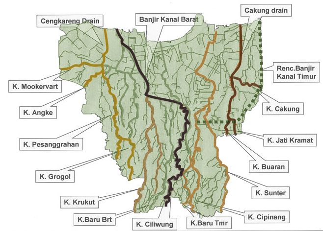 Angke River ("K. Angke"), upper left in the map of rivers and canals of Jakarta (2012) | |
| Native name |
|
| Location | |
| Country | Indonesia |
| State | Jakarta |
| Physical characteristics | |
| Source | |
| • location | Bogor |
| Mouth | Cengkareng Drain, Java Sea |
• coordinates | 6°07′28″S 106°46′29″E |
• elevation | 1 m (3 ft 3 in) |
| Length | 91.25 km (56.70 mi) |
| Basin features | |
| Tributaries | |
| • left | Maja River[1] |
Etymology
The river may be named after prince Tubagus Angke, from the Banten Sultanate, who was the ruler of Jayakarta in the 16th century. Another theory is that the name refers to the 1740 Batavia massacre in which 10,000 ethnic Chinese residents of the city were massacred by the Dutch East India Company, with many bodies dumped in the river. Ang means "red" in the Hokkien dialect, which could refer to the bloody event.[5]

Hydrology
The main river has a length of 91.25 kilometres (56.70 mi), with the watershed area (Indonesian: Daerah Pengaliran Sungai) of 480 km².[4] The average daily rainfall is 132 mm, with the peak debit at 290 m³.[4] The river never dries throughout the year, because it connects directly to a constant source at the districts of Menteng dan Cilendek Timur in the city of Bogor, East Java. From there it flows through the territory of South Tangerang, Tangerang, Jakarta and drains to Java Sea in the village of Muara Angke (literally: "(river) mouth of Angke"), Penjaringan, West Jakarta. In rainy seasons, the river annually causes local flood, usually in the districts of Pinang, Cipondoh, Ciledug (all in Tangerang), Joglo, Kembangan, Rawa Buaya, Duri Kosambi and Cengkareng (all in West Jakarta).[6][7][8]
Geography
The river flows in the northwest area of Java with predominantly tropical rainforest climate (designated as Af in the Köppen-Geiger climate classification).[9] The annual average temperature in the area is 27 °C. The warmest month is March, when the average temperature is around 30 °C, and the coldest is May, at 26 °C.[10] The average annual rainfall is 3674 mm. The wettest month is December, with an average of 456 mm rainfall, and the driest is September, with 87 mm rainfall.[11]
Historic place


Fort Anké was built by the Dutch East India Company in 1657[12] at the intersection of the Mookervaart channel and Angke river.[13] Historical names for the fort include: Anckee, Anke, Ankee.[14]
See also
References
- Simanjuntak, T. P. Moan (16 July 2014). "Maja River in Pegadungan Strewn with Water Hyacinth and Mud". Berita Resmi Pemprov. Archived from the original on 18 March 2015. Retrieved 3 December 2018.
- Kali Angke in West Java
- Mouth of Kali Angke to Java Sea - Geonames.org
- BBWS Ciliwung Cisadane. Pengendalian Banjir dan Perbaikan Sungai Ciliwung Cisadane (PBPS CC). Archived in Konservasi DAS Ciliwung - April 2012.
- (in Indonesian) Horde, G. dkk. 2012. "Sejarah Kawasan Angke Di Batavia". Article in Budaya Tionghoa dated 20 March 2012. Accessed 03 May 2017.
- Poskota: Kali Angke Meluap, Ciledug Indah Kebanjiran Archived 2017-09-02 at the Wayback Machine. Berita Jumat, 23 Januari 2015 - 13:59 WIB
- Tribun News: Banjir di Kota Tangerang Disebabkan Kali Angke Meluap. Berita Senin, 14 November 2016 - 12:25 WIB
- Okezone: Waduh! Rawa Buaya dan Duri Kosambi Terendam Banjir. Berita Kamis, 23 Maret 2017 - 09:39 WIB
- Peel, M C; Finlayson, B L; McMahon, T A (2007). "Updated world map of the Köppen-Geiger climate classification". Hydrology and Earth System Sciences. 11. doi:10.5194/hess-11-1633-2007.
- "NASA Earth Observations Data Set Index". NASA. 30 January 2016.
- "NASA Earth Observations: Rainfall (1 month - TRMM)". NASA/Tropical Rainfall Monitoring Mission. 30 January 2016.
- "Angke, Fort" (in Indonesian). Jakarta City Administration. Archived from the original on November 7, 2016. Retrieved July 6, 2011.
- "Vijfhoek Redoute". Jakarta Encyclopedia. Department of Communication, Informatics and Public Relations of Jakarta Capital City. 1995–2012. Archived from the original on August 8, 2014. Retrieved August 1, 2014.
- "Anckee". Atlas of Mutual Heritage. AMH. 2014. Retrieved August 1, 2014.
Другой контент может иметь иную лицензию. Перед использованием материалов сайта WikiSort.org внимательно изучите правила лицензирования конкретных элементов наполнения сайта.
WikiSort.org - проект по пересортировке и дополнению контента Википедии