geo.wikisort.org - River
The Buaran River (Kali Buaran) is a river flowing in the Bekasi, West Java and eastern part of the Special Capital Region of Jakarta, Indonesia.[1] The lower portions of the original river have been channelized and directed into the eastern flood canal, "Banjir Kanal Timur", which continues to flow to the Java Sea in the district of Marunda, Cilincing, North Jakarta.[2] The river regularly causes flooding in the city of Bekasi[3] and Jakarta.[4]
| Buaran River Kali Boearan | |
|---|---|
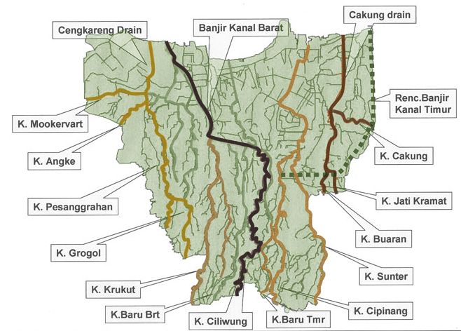 Buaran River ("K. Buaran"), middle right in the map of rivers and canals of Jakarta (2012) | |
 Location of the mouth  Buaran River (Indonesia) | |
| Native name | Kali Buaran (Indonesian) |
| Location | |
| Country | Indonesia |
| State | Jakarta |
| Physical characteristics | |
| Source | |
| • location | Bekasi, West Java |
| Mouth | Banjir Kanal Timur |
• coordinates | 6°11′01″S 106°55′44″E |
| Length | 18.87 km (11.73 mi) |
History
Buaran and the other two nearby rivers, the Cakung and Jatikramat, flow from Bekasi and interconnect until draining into the Jakarta Bay in the district of Marunda through Cakung Drain and currently through Banjir Kanal Timur. In the past, the three rivers supplied water for drinking and agriculture in the area.[5]
Since 1966, based on the information of the river authority (Balai Besar Wilayah Sungai Citarum; www.bbwscitarum.com), Buaran was one of the four rivers passed by Tarum Barat Canal or known as "Kalimalang". Buaran and Jatikramat lie about 5 meter beneath Kalimalang. This canal cross east-westward through a specially built bridge above the stream of Buaran and Jatikramat.[6]
By 1990 the people could still swim or bath in the Buaran River. Entering 1993 the rice field area around housing diminished, transformed into buildings, especially since the construction of fly-over connecting Radjiman Street and Radin Inten II Street. The fly-over connects the area of Duren Sawit and Pulogadung. Due to the proximity to industrial area of Pulogadung, the houses in Kampung Warudoyong multiplied. Semi-permanent buildings were growing along the river banks. Since then, the river became dirty and dark.[7]
The river often causes flooding to the surrounding area. A research by Pieter J Kunu and H Lelolterry of the Pattimura University, Ambon, showed that the development of the city changed 85% land of Jakarta to be waterproof, unable to absorb surface water and resulted in regular floods. One of the solutions was by constructing a flood-control canal, Banjir Kanal Timur.[5] The flow of the Cakung, Buaran, Jati Kramat, Sunter, and Cipinang rivers was cut to drain into the canal, and thereby reducing the occurrence of flood.[5] However, one little part of the Jatikramat River is now still connected to the Buaran River at a length of almost 50 meter.[6] The flow of Buaran itself seems not to change much. The width is nearly the same before or after the canal, until the river flows into Cakung Drain.[6]
Hydrology
The Buaran River has a length of 18.87 kilometres (11.73 mi), with the watershed area (Indonesian: Daerah Pengaliran Sungai) of 13 km².[8] The average daily rainfall is 158 mm, with the peak debit at 50 m³.[8]
Geography
The river flows in the northwest area of Java with predominantly tropical rainforest climate (designated as Af in the Köppen-Geiger climate classification).[9] The annual average temperature in the area is 28 °C. The warmest month is September, when the average temperature is around 31 °C, and the coldest is May, at 26 °C.[10] The average annual rainfall is 3674 mm. The wettest month is December, with an average of 456 mm rainfall, and the driest is September, with 87 mm rainfall.[11]
Normalisation
In 2016 the Jakarta government started the normalisation project on the Buaran River, starting by the removal of the illegal building along the river banks.[12]
References
- Kali Buaran - Geonames.org.
- (in Indonesian) Wujudkan Wisata Sungai, Kemenpar Dukung Sport Tourism BKT 5K - Nofie Tessar, Liputan6, 13 Sep 2017.
- Jakarta, Bekasi, dan Tangerang Masih Rawan Banjir - Alsadad Rudi, Kompas.com - 21 Feb 2017.
- Kali Buaran Meluap, Permukiman di Taman Malaka Selatan Tergenang, Robertus Belarminus, Kompas.com - 21 Feb 2017.
- (in Indonesian) Tiga Sungai Menghidupkan Timur Jakarta, Kompas.com - 28 Mei 2016.
- (in Indonesian) Kanal Timur yang Mengubah Alur Sungai. Kompas.com - 24 Mei 2016.
- (in Indonesian) Kesadaran Menjaga Sungai yang Semakin Runtuh. Kompas.com - 08 Jun 2016.
- (in Indonesian) BBWS Ciliwung Cisadane. Pengendalian Banjir dan Perbaikan Sungai Ciliwung Cisadane (PBPS CC). https://konservasidasciliwung.wordpress.com/kebijakan-tentang-ciliwung/bbws-ciliwung-cisadane/ Archived in Konservasi DAS Ciliwung] - April 2012.
- Peel, M C; Finlayson, B L; McMahon, T A (2007). "Updated world map of the Köppen-Geiger climate classification". Hydrology and Earth System Sciences. 11. doi:10.5194/hess-11-1633-2007.
- "NASA Earth Observations Data Set Index". NASA. 30 January 2016. Archived from the original on 26 April 2020. Retrieved 13 October 2017.
- "NASA Earth Observations: Rainfall (1 month - TRMM)". NASA/Tropical Rainfall Monitoring Mission. 30 January 2016. Archived from the original on 19 April 2019. Retrieved 13 October 2017.
- 63 Bangunan di Bantaran Kali Dibongkar, Penghuni Mau Pulang Kampung Archived 2017-10-14 at the Wayback Machine - PoskotaNews - 30 Agustus 2016.
Другой контент может иметь иную лицензию. Перед использованием материалов сайта WikiSort.org внимательно изучите правила лицензирования конкретных элементов наполнения сайта.
WikiSort.org - проект по пересортировке и дополнению контента Википедии