geo.wikisort.org - River
The Cipinang River is a river flowing in the Special Capital Region of Jakarta, Indonesia.[1] Cipinang river is a tributary of Sunter River,[2] conjoining near I Gusti Ngurah Rai Street and Cipinang Muara Ilir Street, Jakarta,[3] but in the middle it is cut by the beginning of Banjir Kanal Timur, near Cipinang Besar Selatan Street dan IPN Street, Jakarta.[4] The river flows mainly in the district of Makassar, East Jakarta, with many houses built on both banks.[5]
| Cipinang River Kali Cipinang, Cipinang, Kali Tjipinang, Tjipinang | |
|---|---|
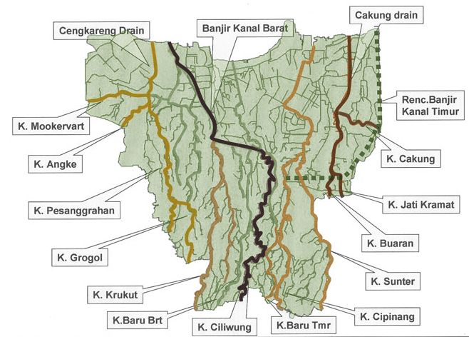 Cipinang River ("K. Cipinang"), bottom right in the map of rivers and canals of Jakarta (2012) | |
 Location of the mouth  Cipinang River (Indonesia) | |
| Location | |
| Country | Indonesia |
| State | Jakarta |
| Physical characteristics | |
| Source | |
| • location | Depok, West Java |
| Mouth | Banjir Kanal Timur, Sunter River |
• coordinates | 6°12′45″S 106°53′44″E |
| Length | 37.68 km (23.41 mi) |
History
Cipinang river has the upstream in Depok, West Java, and flowing to the direction of Banjir Kanal Timur and Sunter River. Its water used to be very clear, that the local people utilized it for bathing, before more people settled there. There were many types of fish found along the river: tilapia, Java barb, dan catfish.[6] Its width reached seven meter with a depth of four meter.[6]
However, in the last ten years more houses were erected on both banks. The river became narrower and its water quality was neglected, until turned black and heavily polluted from various industrial sources.[6] Former ponds on its banks were transformed as trash collection mounds. Therefore, during the rain season the river often causes flooding to the surrounding area.[6] According to the local residents, the worst flood was in 2015. In January 2017, after the normalization was initiated, the condition improved, but the flooding still happened.[7]
Hydrology
Cipinang river has a length of 37.68 kilometres (23.41 mi), with the watershed area (Indonesian: Daerah Pengaliran Sungai) of 57.45 km2.[2] The average daily rainfall is 136 mm, with the peak debit at 85 m3.[2]
Geography
The river flows in the northwest area of Java with predominantly tropical rainforest climate (designated as Af in the Köppen-Geiger climate classification).[8] The annual average temperature in the area is 28 °C. The warmest month is September, when the average temperature is around 31 °C, and the coldest is May, at 26 °C.[9] The average annual rainfall is 3674 mm. The wettest month is December, with an average of 456 mm rainfall, and the driest is September, with 87 mm rainfall.[10]
Normalisation
In 2014 the Jakarta government started the normalisation of Cipinang river, from Cibubur to Banjir Kanal Timur. Pengukuran sudah dilakukan sejak tahun 2014. The river will be widened to 12 meter with a depth of 3 meter.[6] The accumulated garbage was never removed for 30 years until finally was transported completely under the instruction of the Governor Basuki Tjahaja Purnamaon 13 September 2015.[11][12] For the normalisation of water flow, some residents had to be moved, and the government bought the houses and lands along the banks. The government of Jakarta put much effort for this normalisation to free East Jakarta from future flooding.[5]
Notes and references
- Soehoed, Abdoel Raoef (2002). Banjir Ibukota: Tinjauan Historis Dan Pandangan Ke Depan: Serangkaian Pemikiran Strategi Terpadu Jangka Panjang. Djambatan. p. 30. ISBN 978-979-428-449-0, 9794284491.
- (in Indonesian) BBWS Ciliwung Cisadane. Pengendalian Banjir dan Perbaikan Sungai Ciliwung Cisadane (PBPS CC). https://konservasidasciliwung.wordpress.com/kebijakan-tentang-ciliwung/bbws-ciliwung-cisadane/ Archived in Konservasi DAS Ciliwung] - April 2012.
- Kali Cipinang - Geonames.org.
- Way: Kali Cipinang (489766190) OpenStreetMap.
- Pemda DKI Genjot Normalisasi Kali Cipinang - Aghnia Adzkia, CNN Indonesia - 27 Apr 2016.
- Keindahan Alam Kali Cipinang yang Hilang Setelah Jadi Gunung Sampah - Robertus Belarminus, Kompas.com - 14 Sep 2015.
- (in Indonesian) Sekitar Kali Cipinang Masih Banjir, Ahok: Normalisasi Belum Selesai - Bisma Alief Laksana, detik.com - 16 Jan 2017.
- Peel, M C; Finlayson, B L; McMahon, T A (2007). "Updated world map of the Köppen-Geiger climate classification". Hydrology and Earth System Sciences. 11. doi:10.5194/hess-11-1633-2007.
- "NASA Earth Observations Data Set Index". NASA. 30 January 2016. Archived from the original on 6 August 2013. Retrieved 1 November 2017.
- "NASA Earth Observations: Rainfall (1 month - TRMM)". NASA/Tropical Rainfall Monitoring Mission. 30 January 2016.
- 30 Tahun Sampah Menggunung di Cipinang Akhirnya Diangkut - Kompas.com - 14 Sep 2015.
- Ahok Sebut "Malu-maluin" Sampah Kali Cipinang Baru Diangkut... - Kurnia Sari Aziza, Kompas.com - 14 Sep 2015.
Другой контент может иметь иную лицензию. Перед использованием материалов сайта WikiSort.org внимательно изучите правила лицензирования конкретных элементов наполнения сайта.
WikiSort.org - проект по пересортировке и дополнению контента Википедии