geo.wikisort.org - Reservoir
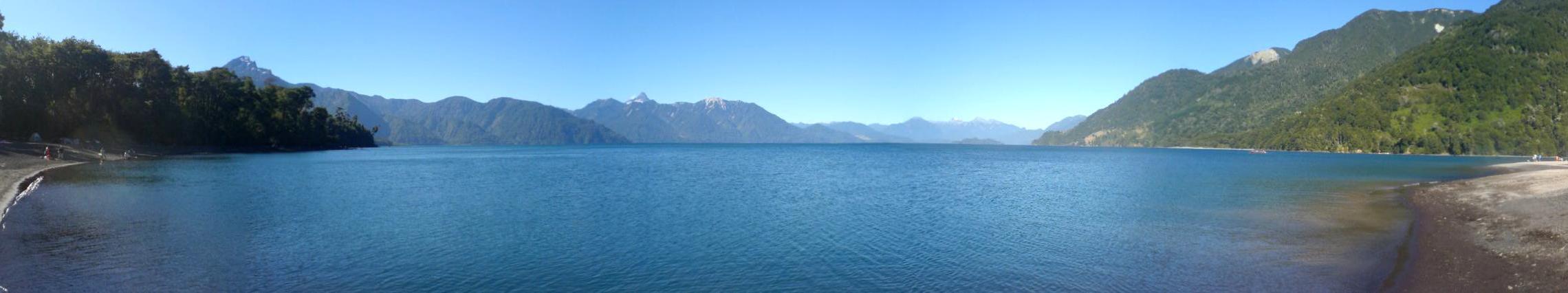
Lake Todos los Santos (Spanish for "All Saints Lake") is a lake located in the Los Lagos Region of southern Chile, 96 km northeast of the regional capital Puerto Montt and 76 km east of Puerto Varas, within the boundaries of the Vicente Pérez Rosales National Park. It has a surface area of 178.5 km² and a maximum depth of 337 m.[1] The Lake's National Park status has ensured protection to its environment. The catchment is largely covered with old-growth Valdivian temperate rain forests. The present form of the lake is the result of glacial and volcanic processes.[1][2]
| Lake Todos los Santos | |
|---|---|
 | |
 Lake Todos los Santos | |
| Coordinates | 41°06′S 72°12′W |
| Type | monomictic |
| Catchment area | 3,036 km2 (1,172 sq mi) |
| Basin countries | Chile |
| Surface area | 178.5 km2 (68.9 sq mi) |
| Max. depth | 337 m (1,106 ft) |
| Water volume | 34.4 km3 (27,900,000 acre⋅ft) |
| Residence time | 4 years |
| Surface elevation | 189 m (620 ft) |
| Islands | one (Isla Margarita) |
Hydrology
The main tributary of the lake is the Río Peulla/Río Negro, next to the Peulla locality. Its outflow at the Petrohué locality gives rise to the Petrohué River, with an average outflow of 270 m³ per second. Even though the lake has a regulating effect, it is subject to water level variations that may exceed 3 m and reflect in the discharge at the outflow. At a short distance from the Petrohué locality, the river flows through the Petrohué Waterfalls.
The lake may appear green, blue or silver depending on the cloud cover and weather on a given day. The majority of the greenish tint comes from glacial meltwater containing mineral debris.[3]
History
As recently as 20,000 years ago, the basin of Todos los Santos Lake was filled by a large glacier that did not withdraw until approximately 10,000 years ago.[3] At that point, the area was still a glacial basin with rivers flowing through it. The lake itself did not form until lava flows from the Osorno and Calbuco volcanoes formed a dam across the lower part of the valley, trapping the water from the rivers and gradually forming the lake.[3]
This lake has been known by multiple indigenous names in the past: Purailla, Pichilauquen, and Quechocavi.[citation needed] German colonists in the 19th century labelled it Lake Esmeralda ("Emerald Lake"), due to the green color of its water.[3] However, later practice reverted to the name given by Jesuit missionaries, Todos los Santos Lake.[3]
Tourism
A regular road and boat transport service provides tourist transport between Puerto Montt or Puerto Varas in Chile and San Carlos de Bariloche on Nahuel Huapi Lake in Argentina. There are two main lake ports: Petrohué at the western end, and the village of Peulla at the eastern end; there is no road connecting these ports. The lake is surrounded by steep mountains leaving only minor plains. The mountains include Osorno volcano in the west, the Puntiagudo to the north, and the Tronador to the east.
References
| Wikimedia Commons has media related to Todos los Santos Lake. |
- "Lake Todos los Santos". World Lakes Database. International Lake Environment Committee Foundation. Retrieved 2014-01-19.
- "Cayutué-La Viguería". Global Volcanism Program. Smithsonian Institution. Retrieved 2006-10-27.
- Scheffel, Richard L.; Wernet, Susan J., eds. (1980). Natural Wonders of the World. United States of America: Reader's Digest Association, Inc. pp. 382–383. ISBN 0-89577-087-3.
- (in English) All on Lake Todos los Santos, Chile
На других языках
[de] Lago Todos los Santos
Lago Todos los Santos (wörtlich: „Allerheiligensee“) ist ein großes Stillgewässer im südlichen Chile, der in Bezug auf Fläche, Tiefe und Wasservolumen in etwa mit dem Lago Maggiore vergleichbar ist.- [en] Todos los Santos Lake
[es] Lago Todos los Santos
El Lago Todos los Santos se sitúa en la X Región de Los Lagos, Chile, a 96 km al noreste de la capital regional Puerto Montt y 76 km al este de la ciudad de Puerto Varas, dentro de los confines del parque nacional Vicente Pérez Rosales. Tiene una superficie de 178.5 km², una altitud de 189 metros sobre el nivel del mar y una profundidad máxima de 337 metros.[1] En su ribera se encuentran las localidades de Petrohue, Peulla y Cayutué.[fr] Lac Todos los Santos
Le lac Todos los Santos, toponyme espagnol signifiant littéralement en français « lac de tous les saints », nommé ainsi en raison de sa découverte par les explorateurs espagnols le jour de la Toussaint, est un lac du Sud du Chili, dans la province d'Osorno de la région des Lacs. Contrairement à la majorité des autres lacs de la région, celui-ci s'enfonce profondément dans la cordillère des Andes, entouré de sommets dont les volcans Osorno et Puntiagudo.[it] Lago Todos los Santos
Il Todos los Santos (in italiano Tutti i Santi), è un lago cileno che si trova sulla Regione dei Laghi, vicino al confine con l'Argentina, nel Parco Nazionale Vicente Pérez Rosales, il più antico del paese.[ru] Тодос-лос-Сантос
Тодос-лос-Сантос (исп. Lago Todos los Santos, что в переводе с испанского означает «Озеро всех святых») — озеро в области Лос-Лагос в южном Чили.Другой контент может иметь иную лицензию. Перед использованием материалов сайта WikiSort.org внимательно изучите правила лицензирования конкретных элементов наполнения сайта.
WikiSort.org - проект по пересортировке и дополнению контента Википедии