geo.wikisort.org - Reservoir
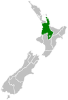
Ohakuri is a dam and hydroelectric power station on the Waikato River, central North Island, New Zealand, midway between Taupo, Rotorua and Hamilton. Its dam is about 5 kilometres (3.1 mi) upstream of the Atiamuri Dam.
| Ohakuri Dam | |
|---|---|
 Ohakuri dam and powerhouse from the north. | |
 Location of Ohakuri Dam in New Zealand | |
| Country | New Zealand |
| Location | Between Taupo, Rotorua, and Hamilton |
| Coordinates | 38°24′30″S 176°5′22″E |
| Purpose | Power |
| Status | Operational |
| Opening date | 1961 |
| Owner(s) | Mercury Energy |
| Dam and spillways | |
| Type of dam | earth dam with concrete gravity sections for the intake and spillway structures[1] |
| Impounds | Waikato River |
| Reservoir | |
| Creates | Lake Ohakuri |
| Surface area | 12 km2 (4.6 sq mi) |
| Ohakuri Power Station | |
| Operator(s) | Mercury Energy |
| Turbines | 4× 28 MW Francis turbine |
| Installed capacity | 112 MW (150,000 hp) |
It was commissioned in 1961 and construction was organised from the 'hydro town' of Mangakino.[2] The dam eventually created Lake Ohakuri, the largest artificial lake on the Waikato,[3] which drowned two thirds of the Orakei Korako geothermal area as well as hot springs and wahi tapu (Māori sacred sites) at Te Ohaaki.[2] Creation of the dam forced Ngāti Tahu to relocate their Ohaaki Marae.[4] The submerged area also included two of the world's largest geysers (Minginui Geyser and Orakei Korako Geyser).[5]
The construction in the face of these negative effects was considered justified at the time due to the serious electricity shortages plaguing the country after World War II, and by the fact that laws requiring public participation or consultation were not introduced until much later. While compensation to Māori land owners was paid based on the land take rules of the Public Works Act, the damage to the inhabitants of the area was to form basis of further legal actions under the Waitangi Tribunal legislation many years later.[2]
Power station
The Ohakuri Power Station has a capacity of 112 megawatts (150,000 hp) and is operated by Mercury Energy.
Gallery
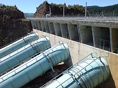 The penstocks seen from the west
 Aerial view of Ohakuri Power Station, February 1969


References
- "404". Archived from the original on 10 June 2011.
{{cite web}}: Cite uses generic title (help) - Section 16.3 (from the Pouakani Report 1993, Waitangi Tribunal. Accessed 2008-01-16.)
- "Ohakuri". Mighty River Power. Archived from the original on 27 September 2011. Retrieved 13 February 2008.
- Ihaka, James (2 September 2009). "Sinking marae's iwi upset at second forced shift". The New Zealand Herald. Retrieved 2 September 2009.
- Tall Geysers, Minority Geoscience Program, University of New Orleans. Accessed 2008-02-13.
Further reading
- Martin, John E, ed. (1991). People, Power and Power Stations: Electric Power Generation in New Zealand 1880 - 1990. Wellington: Bridget Williams Books Ltd and Electricity Corporation of New Zealand. pp. 316 pages. ISBN 0-908912-16-1.
External links
- Hydro Stations: Ohakuri (from the Mighty River Power website. Retrieved 2007-12-01.)
Electricity generation in Waikato | ||||||||||||||
|---|---|---|---|---|---|---|---|---|---|---|---|---|---|---|
| Operating power stations |
|  | ||||||||||||
| Companies |
| |||||||||||||
Другой контент может иметь иную лицензию. Перед использованием материалов сайта WikiSort.org внимательно изучите правила лицензирования конкретных элементов наполнения сайта.
WikiSort.org - проект по пересортировке и дополнению контента Википедии