geo.wikisort.org - Reservoir
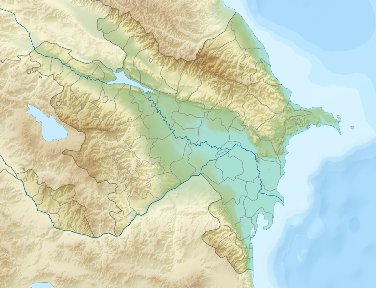
The Mingachevir reservoir (Azerbaijani: Mingəçevir su anbarı) or The Mingachevir sea (Azerbaijani: Mingəçevir dənizi),[1][2][3][4]) is a large reservoir in northwestern Azerbaijan. It is the largest reservoir in the Caucasus.[5] The reservoir's filling began in 1953 and was completed in 1959.[6]
This article uses bare URLs, which are uninformative and vulnerable to link rot. (September 2022) |
| Mingachevir Reservoir | |
|---|---|
 Mingachevir Reservoir | |
 Mingachevir Reservoir | |
| Location | Mingachevir |
| Coordinates | 40°47′20″N 47°01′40″E |
| Type | reservoir |
| Primary inflows | Kura River, Alazani, Iori/Qabırlı |
| Primary outflows | Kura River |
| Basin countries | Azerbaijan |
| Built | 1953 |
| Max. length | 70 km (43 mi) |
| Max. width | 18 km (11 mi) |
| Surface area | 605 km2 (234 sq mi) |
| Average depth | 26 m (85 ft) |
| Max. depth | 75 m (246 ft) |
| Water volume | 15.730 km3 (12,753,000 acre⋅ft) |
| Shore length1 | 247 km (153 mi) |
| 1 Shore length is not a well-defined measure. | |
Overview
The reservoir was built on a section of Kura River flowing through Mount Bozdağ in 1953.[7] The filling capacity of the reservoir is 83 m (272 ft) whereas the volume is 15.73 km³. It has been filled to its maximum levels in 1959, 1963, 1968, 1973, 1975, 1976, 1978, 1988 and 2010.[8] The length is 70 km (43 mi) and width is 18 km (11 mi). Maximum depth is 75 m (246 ft), average depth - 26 m (85 ft). The length along the shoreline is 247 km (153 mi), the overall area is 605 km2 (234 sq mi).[6][9][10] The largest hydroelectric power station of Azerbaijan is located on the reservoir. Mingachevir Hydro Power Plant has an installed electric capacity of 401.6 megawatts.[11] The length of the hydroelectric dam is 1,550 m (5,090 ft), its width is 16 m (52 ft) and height is 80 m (260 ft).[9]
The reservoir supplies water to Upper Karabakh and Upper Shirvan channels. It is also a source for fishing, water supplies and irrigation.
Orographic description
Cliffs are particular for both banks of the river Kur and they are also observed where the river flows into Mingachevir reservoir. However, sandy-clayey sediments belonging to the Paleogene-Neogene are widespread in the area of reservoir. At the edges of the Mingachevir reservoir, landslide processes occur periodically.[12]
As a possible military target
Within the context of the Nagorno-Karabakh conflict, scholars and politicians have speculated the possibility of the Mingachevir reservoir being used as a military target by Armenian forces. Russian ethnographer Sergey Arutyunov stated in a 2010 interview:[13]
I will not disclose a military secret—this has been openly admitted in Armenia's general staff—that Armenian or NKR artillery batteries, stationed at the top of Karabakh mountains, are 40 kilometers away from the Mingachevir reservoir. One strike and central Azerbaijan will turn into a sea.
In the aftermath of the 2014 Armenian–Azerbaijani clashes, Armenia's Defense Minister Seyran Ohanyan stated at the government session on August 7 that the Troops of the Civil Defense of the Azerbaijani Ministry of Emergency Situations have recently been mainly protecting the Mingachevir Hydro Power Plant fearing an attack by the Armenian forces.[14] In response, the Azerbaijani Defense Ministry issued a statement the next day which said that "the Armenian people should know that the response to any sabotage attempts against Mingachevir Hydro Power Plant from the Armenian side will be more miserable"[15] and cautioned that Azerbaijan had the capability to raze Yerevan, Armenia's capital.[16]
Telman Zeynalov, president of the National Center of Environmental Forecasting, said in an interview that the entire area from Arran (i.e. the great triangle of land, lowland in the east but rising to mountains in the west, formed by the junction of the rivers Kura and Aras)[17] to Baku, the Azerbaijani capital, would be flooded if Mingachevir Dam was destroyed. In his words, it would lead to a "large-scale environmental disaster." Zeynalov added that the Armenian side should be cautious because the flooding "would affect both sides" and most of Armenian-occupied Karabakh would also be flooded.[18] The latter claim was rejected by Armenian analyst Hrant Melik-Shahnazaryan who stated that the waters of the Mingachevir reservoir cannot possibly reach the highlands of Karabakh.[19]
Armenia's former defense minister Vagharshak Harutiunyan mentioned attacking the reservoir dam in a July 2020 interview.[20]
Vagif Dargahli, spokesperson of Azerbaijan's Ministry of Defense stated in July 2020 that the "land topography of the Mingachevir water reservoir, protective land works in the area and advanced air defense systems in service with the country’s missile defense troops make a strike on this strategically important facility impossible."[21]
See also
- Rivers and lakes in Azerbaijan
- Shamkir reservoir
References
- https://www.gramota.net/articles/issn_1997-292X_2012_9-1_01.pdf [bare URL PDF]
- Ilʹin, Mikhail (1948). "От Черного до Каспийского моря".
- Davydov, Mitrofan (1958). "От Волхова до Амура".
- "Azərbaycan Milli Kitabxanası".
- Coene, Frederik (2010). The Caucasus : an introduction. London: Routledge. ISBN 978-0-415-48660-6.
- Swietochowski, Tadeusz; Collins, Brian C. (1999). Historical Dictionary of Azerbaijan. Scarecrow Press. p. 81. ISBN 978-0-8108-3550-4.
- "Rivers, Lakes and Reservoirs of Azerbaijan Republic". Ministry of Ecology and Natural Resources (Azerbaijan). Archived from the original on 2 July 2014. Retrieved 11 June 2014.
- Mingəçevir Su Anbarında su maksimal səviyyəyə çatıb Archived 2016-03-03 at the Wayback Machine Retrieved on 23 October 2010
- AZƏRBAYCAN RESPUBLİKASI MELİORASİYA VƏ SU TƏSƏRRÜFATI AÇIQ SƏHMDAR CƏMİYYƏTİ: SU ANBARLARI Archived 2011-01-19 at the Wayback Machine
- Water resources in Azerbaijan Archived 2011-07-10 at the Wayback Machine
- Mingechevir HydroElectric Power Plant Archived 2012-02-17 at the Wayback Machine Retrieved on 23 October 2010
- Urban Groundwater Management and Sustainability. Springer. October 2006. ISBN 9781402051746.
- "Մի համազարկ' եւ կենտրոնական Ադրբեջանը ծով կդառնա". Hetq (in Armenian). 16 August 2010. Archived from the original on 17 May 2016. Retrieved 4 February 2021.
- Shoghikyan, Hovhannes (7 August 2014). ""Մեր զինված ուժերը պատրաստ են իրենց առջև դրված խնդիրն իրականացնելու"․ Օհանյան". azatutyun.am (in Armenian). Radio Free Europe/Radio Liberty. Archived from the original on 3 October 2015. Retrieved 4 February 2021.
Պաշտպանության նախարար Սեյրան Օհանյանը արձագանքեց, որ Ադրբեջանի արտակարգ իրավիճակների նախարարության քաղպաշտպանության զորքերը վերջին շրջանում հիմնականում պաշտպանում են Մինգեչաուրի ջրամբարը՝ մտավախություն ունենալով, որ հայկական կողմը կարող է այդտեղ գործողություններ իրականացնել։
- "Azerbaijani Defense Ministry: "Our Army, targeting Armenia with missiles, is ready to fulfill even the order of destroying Yerevan"". apa.az. 8 August 2014. Archived from the original on 5 March 2016. Retrieved 4 February 2021.
- Bender, Jeremy (8 August 2014). "Azerbaijan's Army Says It Is 'Ready To Fulfill Even The Order Of Destroying' Armenia's Capital City". Business Insider. Archived from the original on 4 October 2020. Retrieved 4 February 2021.
- Bosworth, C. E. (15 December 1986). "Arrān". Encyclopædia Iranica. Archived from the original on 27 July 2017. Retrieved 4 February 2021.
- "Тельман Зейналов: "Если армяне взорвут Мингечаур, то Карабах останется под водой"". haqqin.az (in Russian). 7 August 2014. Archived from the original on 8 October 2020. Retrieved 4 February 2021.
- "Հրանտ Մելիք-Շահնազարյանն արձագանքել է ադրբեջանական հոխորտանքներին. "Ջրերը չեն կարող դաշտավայրից լեռներ հոսել"" (in Armenian). Armenpress. 7 August 2014. Archived from the original on 3 October 2015. Retrieved 4 February 2021.
- "Մեր հարվածային ուժերը կարող են ոչնչացնել Ադրբեջանում բոլոր թիրախները, այդ երկրի 2/3 կմնա ջրի տակ․ Վաղարշակ Հարությունյան". factor.am (in Armenian). 2 July 2020. Archived from the original on 13 July 2020.
- "Baku, Yerevan exchange statements on possibility of striking critical infrastructure". tass.com. TASS. July 17, 2020. Archived from the original on 4 August 2020. Retrieved 4 February 2021.
Authority control | |
|---|---|
| General |
|
| National libraries | |
| Other | |
На других языках
[de] Mingəçevir-Stausee
Der Mingəçevir-Stausee ist der größte Stausee in Aserbaidschan und einer der größten im Kaukasus. Er befindet sich in der Nähe der Stadt Mingəçevir.- [en] Mingachevir reservoir
[fr] Réservoir de Mingachevir
Le réservoir de Mingachevir ou Mingəçevir (en azéri) est un réservoir situé vers Mingachevir, en Azerbaïdjan. Il constitue la plus grande réserve d'eau du pays et le plus grand réservoir du Caucase avec une superficie de 605 km2.[it] Bacino di Mingäçevir
Il bacino di Mingäçevir o Mingachevir (in russo) è un lago artificiale situato nei pressi di Mingäçevir, in Azerbaigian. Costituisce la maggiore riserva d’acqua del paese e, con una superficie di 605 km², è il più grande lago artificiale del Caucaso.[ru] Мингечевирское водохранилище
Мингечевирское водохранилище[1][2][3] (устар. Мингечау́рское водохрани́лище; азерб. Mingəçevir su anbarı) — водохранилище в Азербайджане, образовано на реке Кура при строительстве плотины Мингечевирской ГЭС у Мингечевира. Площадь 605 км², объём 16,1 км³, длина 70 км, наибольшая ширина 18 км, средняя глубина 27 м, наибольшая — 75 м. Заполнялось с 1953 по 1959 годы[4]. Высота над уровнем моря — 83 м[5].Другой контент может иметь иную лицензию. Перед использованием материалов сайта WikiSort.org внимательно изучите правила лицензирования конкретных элементов наполнения сайта.
WikiSort.org - проект по пересортировке и дополнению контента Википедии