geo.wikisort.org - Reservoir
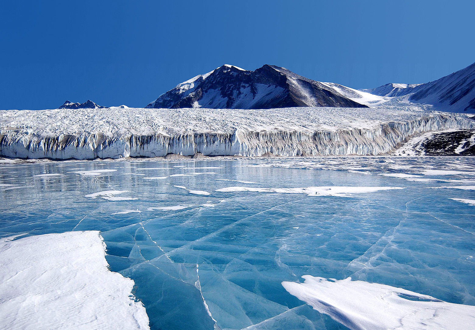
Lake Fryxell is a frozen lake 4.5 kilometres (2.8 mi) long, between Canada Glacier and Commonwealth Glaciers at the lower end of Taylor Valley in Victoria Land, Antarctica. It was mapped in the early 1900s and named during Operation Deep Freeze in the 1950s. There are several forms of algae living in the waters[1] and a weather station located at the lake.[2]
| Lake Fryxell | |
|---|---|
 Lake Fryxell | |
 Lake Fryxell | |
| Location | Taylor Valley, Victoria Land, Antarctica |
| Coordinates | 77°37′S 163°11′E |
| Lake type | Endorheic |
| Primary inflows | Crescent Stream, Harnish Creek |
| Primary outflows | none |
| Catchment area | 230 km2 (89 sq mi) |
| Basin countries | (Antarctica) |
| Max. length | 5.8 km (3.6 mi) |
| Max. width | 2.1 km (1.3 mi) |
| Surface area | 7.8 km2 (3.0 sq mi) |
| Average depth | 3.2 m (10 ft) |
| Max. depth | 20 m (66 ft) |
| Water volume | 25.2×10⁶ m3 (890×106 cu ft) |
| Surface elevation | 18 m (59 ft) |
| Islands | moraine islands |
| Settlements | Lake Fryxell Camp, Lake Fryxell Hut |
Geography
Lake Fryxell is 20 metres (66 ft) deep, making it so the deepest portion of the lake is below sea level. The lake is dammed by Canada Glacier, making it so that it has no natural outflow. It is covered with about 4.5 metres (15 ft) of ice, but during the summer months, the ice can clear along the shoreline. There are a few small islands as well as several shallow areas.[1][3]
The average annual ablation is between 30 centimetres (12 in) and 40 centimetres (16 in), which is significantly lower when compared to other nearby frozen water bodies, such as the waters adjacent to Ross Island.[4]
Watershed
The watershed contains thirteen streams flowing into the lake, forming a watershed that has an area roughly 230 km2 (89 sq mi) in size. Where a few of the streams enter the lake there are well-developed deltas.[1] The streams flow for about 4–12 weeks out of the year. Nearly half of the water flowing into the lake comes from Canada, Lost Seal, and Von Guerard streams.[5]
Climate
Lake Fryxell is located within the McMurdo Dry Valleys, which experience an exceptionally dry climate partially due to katabatic winds descending from the nearby mountains. These winds can exceed 320 km/h (200 mph) under certain conditions and can raise the temperature, melting snow and evaporating water.[6][7] Average precipitation in the area surrounding the valley is equivalent to about 3 cm (1.2 in) of rain a year and a mean annual temperature of −20 °C (−4 °F) with summer temperatures getting above freezing.[5]
| Climate data for Lake Fryxell, Antarctica, 1961–1990 normal | |||||||||||||
|---|---|---|---|---|---|---|---|---|---|---|---|---|---|
| Month | Jan | Feb | Mar | Apr | May | Jun | Jul | Aug | Sep | Oct | Nov | Dec | Year |
| Daily mean °F (°C) | 27.0 (−2.8) |
16.2 (−8.8) |
0.9 (−17.3) |
−5.6 (−20.9) |
−9.9 (−23.3) |
−9.2 (−22.9) |
−14.4 (−25.8) |
−17.3 (−27.4) |
−14.3 (−25.7) |
−2.9 (−19.4) |
14.5 (−9.7) |
25.7 (−3.5) |
0.9 (−17.3) |
| Average precipitation days (≥ 1mm) | 2 | 4 | 3 | 4 | 5 | 5 | 4 | 4 | 3 | 3 | 2 | 2 | 41 |
| Source: Norwegian Meteorological Institute[8] | |||||||||||||
Lake Fryxell Camp
Lake Fryxell Camp | |
|---|---|
Camp | |
 One of the buildings located at the nearby camp. | |
Lake Fryxell Camp Location of Lake Fryxell Camp in Antarctica | |
| Coordinates: 77°36′21″S 163°07′32″E | |
| Country | |
| Location in Antarctica | Lake Fryxell Taylor Valley Antarctica |
| Established | 1984 |
| Type | Seasonal |
| Status | Operational |
Mapped by the British Antarctic Expedition under Robert Falcon Scott, 1910–13, the lake was visited by Professor T.L. Péwé during Operation Deep Freeze, 1957–58, who named it for Dr. Fritiof M. Fryxell, glacial geologist of Augustana College, Illinois.
Lake Fryxell is a focus of scientific research and contains a semi-permanent camp containing four labs and two other buildings. Electricity is generated at the camp using solar panels and a wind turbine. The four labs are used for experimenting with radioactive materials, electronics, chemicals and other materials. When staying at the camp, researchers sleep in tents, some of which are the same style as those used in some Antarctic expeditions in the early 20th century. There is internet and phone access at the camp.[9]
Research activities largely deal with the lake itself and can include scientists diving into the water.[10] The camp has existed since at least 1984.[11]
Ecology
There are multiple forms of algae within the lake, including a sizable population of sulfate-reducing bacteria. Some samples of these bacteria live in very specific areas, such as specific water depths or locations causing them to experience differing physiochemical conditions.[12] There are also a few archaea living in the anoxic zone, that contribute to the methane pockets under 12 m below the surface.[13]
There is a lack of oxygen within Lake Fryxell, which is unique when compared to other lakes in the region because the euphotic zone only extends to 9 metres (30 ft) below the lake surface.[14] This creates an environment similar to the planet about 2.4 billion years ago. Within anoxic areas, scientists have found microbial mats that create small pockets saturated with oxygen.[10][15]
See also
- Andrews Creek
- Coral Ridge
- List of Antarctic field camps
- Lake Washburn (Antarctica)
References
- "Waterbody Summary: Antarctic Freshwater Diatoms". Retrieved 17 November 2017.
- "Lake Fryxell Meteorological Station". McMurdo Dry Valleys LTER. Retrieved 31 August 2021.
- Henderson, R. A. (1966). "An Ablation Rate for Lake Fryxell, Victoria Land, Antarctica". Journal of Glaciology. 6 (43): 129–133. Bibcode:1966JGlac...6..129H. doi:10.1017/S0022143000019110.
- Henderson, R. A.; Prebble, W. M.; Hoare, R. A.; Popplewell, K. B.; House, D. A.; Wilson, A. T. (1966). "An Ablation Rate for Lake Fryxell, Victoria Land, Antarctica". Journal of Glaciology. 6 (43): 129–133. doi:10.3189/S0022143000019110.
- Herbei, Radu; Rytel, Alexander L.; Lyons, W. Berry; McKnight, Diane M.; Jaros, Christopher; Gooseff, Michael N.; Priscu, John C. (2016). "Hydrological Controls on Ecosystem Dynamics in Lake Fryxell, Antarctica". PLOS ONE. 11 (7): e0159038. Bibcode:2016PLoSO..1159038H. doi:10.1371/journal.pone.0159038. PMC 4956314. PMID 27441705.
- Bockheim, J. G. (2002). "Landform and Soil Development in the McMurdo Dry Valleys, Antarctica: A Regional Synthesis". Arctic, Antarctic, and Alpine Research. 34 (3): 308–317. doi:10.2307/1552489. JSTOR 1552489.
- Lloyd, John; Mitchinson, John (2006). The Book of General Ignorance. Faber & Faber.
- "Weather statistics for Fryxell, Lake (Antarctica)". Norwegian Meteorological Institute. Retrieved 18 November 2017.
- "6 December 2009 A quick tour of Lake Fryxell Camp". 2009-12-06. Retrieved 17 November 2017.
- "Oxygen Oasis Discovered in Antarctic Lake". Live Science. 3 September 2015. Retrieved 17 November 2017.
- "Lake Fryxell Camp". Retrieved 17 November 2017.
- Karr, EA; Sattley, WM; Rice, MR; Jung, DO; Madigan, MT; Achenbach, LA (2005). "Diversity and distribution of sulfate-reducing bacteria in permanently frozen Lake Fryxell, McMurdo Dry Valleys, Antarctica". Appl Environ Microbiol. 71 (10): 6353–9. Bibcode:2005ApEnM..71.6353K. doi:10.1128/AEM.71.10.6353-6359.2005. PMC 1265979. PMID 16204557.
- Karr, Elizabeth A.; Ng, Joshua M.; Belchik, Sara M.; Sattley, W. Matthew; Madigan, Michael T.; Achenbach, Laurie A. (2006-02-01). "Biodiversity of Methanogenic and Other Archaea in the Permanently Frozen Lake Fryxell, Antarctica". Applied and Environmental Microbiology. 72 (2): 1663–1666. Bibcode:2006ApEnM..72.1663K. doi:10.1128/AEM.72.2.1663-1666.2006. PMC 1392947. PMID 16461723.
- Lawrence, M. J. F. (1985). "Water column and sediment characteristics of Lake Fryxell, Taylor Valley, Antarctica". New Zealand Journal of Geology and Geophysics. 28 (3): 543–552. doi:10.1080/00288306.1985.10421206.
- Krusor, M; Mackey, T. J; Hawes, I; Jungblut, A. D; Eisen, J; Sumner, D. Y (December 2016). "Ecosystem Dynamics of the Microbial Mats in Lake Fryxell, Antarctica". American Geophysical Union. 2016. Bibcode:2016AGUFM.B11F0517K – via ADS.
External links
Antarctica | ||||||||
|---|---|---|---|---|---|---|---|---|
| Geography |
|  | ||||||
| History |
| |||||||
| Politics |
| |||||||
| Society |
| |||||||
| Famous explorers |
| |||||||
| ||||||||
| Authority control: National libraries |
|---|
На других языках
[de] Fryxellsee
Der Fryxellsee (engl. Lake Fryxell) ist ein etwa viereinhalb Kilometer langer meromiktischer See zwischen dem Kanada- und dem Commonwealth-Gletscher in Viktorialand im Osten des antarktischen Kontinents. Er befindet sich im Taylor Valley der Antarktischen Trockentäler. Der Fryxellsee wurde von der Terra-Nova-Expedition (1910 bis 1913) unter Sir Robert Falcon Scott entdeckt und kartografiert und im Jahre 1957 nach Fritiof M. Fryxell (1900–1986), einem Glazialgeologen des Augustana College in Illinois (USA), benannt.- [en] Lake Fryxell
[es] Lago Fryxell
El lago Fryxell es un lago de 4,5 kilómetros de largo, entre el glaciar Canadá y el glaciar Commonwealth, en el valle Taylor, localizado en la Tierra de Victoria, Antártida. La mayor parte del tiempo la superficie del agua está congelada, en forma de hielo azul pues en la parte superior se localiza el agua dulce, mientras que en la parte profunda hay agua salada, con una composición similar a la del agua de mar. A profundidades por debajo de 9,5 m hay elevadas concentraciones de metano y de sulfuro de hidrógeno. La temperatura del agua en verano oscila entre 0,5 y 2,5 °C.[fr] Lac Fryxell
Le lac Fryxell est un lac d'Antarctique situé en terre Victoria, dans la chaîne Transantarctique.[ru] Фрикселл
Фрикселл — бессточное озеро в районе Земли Виктории, Антарктида. Расположено в долине Тейлора Трансантарктического хребта между ледником Канада и ледником Содружества. Длина озера составляет 4,5 км[источник не указан 936 дней], площадь — 7 км²[1]. Располагается на высоте 15 м над уровнем моря[источник не указан 936 дней], имеет глубину 19,2 м[1].Другой контент может иметь иную лицензию. Перед использованием материалов сайта WikiSort.org внимательно изучите правила лицензирования конкретных элементов наполнения сайта.
WikiSort.org - проект по пересортировке и дополнению контента Википедии