geo.wikisort.org - Mountains
The Steeples, is a 2,843-metre (9,327-foot) elevation mountain ridge located at the southern end of the Hughes Range in the Canadian Rockies of British Columbia, Canada. Situated immediately east of Norbury Lake Provincial Park and the Rocky Mountain Trench, this prominent five kilometres in length ridge is visible from the Crowsnest Highway and Cranbrook. Its nearest higher peak is Mount Fisher, 10.0 km (6.2 mi) to the north-northwest.[1]
| The Steeples | |
|---|---|
 The Steeples | |
| Highest point | |
| Elevation | 2,804 m (9,199 ft)[1] |
| Prominence | 609 m (1,998 ft)[1] |
| Parent peak | Mount Fisher (2843 m)[1] |
| Listing | Mountains of British Columbia |
| Coordinates | 49°33′54″N 115°25′20″W[2] |
| Geography | |
 The Steeples Location of The Steeples in British Columbia  The Steeples The Steeples (Canada) | |
| Location | British Columbia, Canada |
| District | Kootenay Land District |
| Parent range | Hughes Range Canadian Rockies |
| Topo map | NTS 82G11 Fernie[2] |
| Climbing | |
| Easiest route | Scrambling |
History
The Steeples was named in August 1858 by Thomas Blakiston of the Palliser Expedition as presumably it was believed to resemble church steeples.[3]
The mountain's name was officially adopted in 1950 when approved by the Geographical Names Board of Canada.[2][4]
Climate
Based on the Köppen climate classification, The Steeples has a subarctic climate with cold, snowy winters, and mild summers.[5] Temperatures can drop below −20 °C with wind chill factors below −30 °C. Precipitation runoff from the mountain drains into tributaries of the Kootenay River.
See also
- Geography of British Columbia
References
- "The Steeples". Bivouac.com. Retrieved 2019-02-22.
- "The Steeples". Geographical Names Data Base. Natural Resources Canada. Retrieved 2019-02-22.
- "The Steeples". PeakFinder.com. Retrieved 2021-06-18.
- "The Steeples". BC Geographical Names. Retrieved 2021-06-18.
- Peel, M. C.; Finlayson, B. L. & McMahon, T. A. (2007). "Updated world map of the Köppen−Geiger climate classification". Hydrol. Earth Syst. Sci. 11: 1633–1644. ISSN 1027-5606.
Gallery
 The eastern slope of The Steeples supports a small glacier
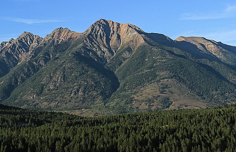 Bull Mountain forms the south end of The Steeples


External links
- Weather forecast: The Steeples
Другой контент может иметь иную лицензию. Перед использованием материалов сайта WikiSort.org внимательно изучите правила лицензирования конкретных элементов наполнения сайта.
WikiSort.org - проект по пересортировке и дополнению контента Википедии