geo.wikisort.org - Mountains
The Taupō Volcanic Zone (TVZ) is a volcanic area in the North Island of New Zealand that has been active for the past two million years and is still highly active. Mount Ruapehu marks its south-western end and the zone runs north-eastward through the Taupō and Rotorua areas and offshore into the Bay of Plenty. It is part of the larger Central Volcanic Region that extends further westward through the western Bay of Plenty to the eastern side of the Coromandel Peninsula and has been active for four million years.[1] At Taupō the rift volcanic zone is widening east–west at the rate of about 8 mm per year while at Mount Ruapehu it is only 2–4 mm per year but this increases at the north eastern end at the Bay of Plenty coast to 10–15 mm per year.[2] It is named after Lake Taupō, the flooded caldera of the largest volcano in the zone, the Taupō Volcano and contains a large central volcanic plateau as well as other landforms associated with its containing tectonic intra-arc continental Taupō Rift.
Taupō Volcanic Zone | |
|---|---|
Volcanic area | |
 | |
 Taupō Volcanic Zone Location of Taupō Volcanic Zone in New Zealand  Taupō Volcanic Zone Taupō Volcanic Zone (North Island) | |
| Coordinates: 38°40′00″S 176°01′00″E | |
| Location | North Island |
| Age | Miocene - Holocene |
| Formed by | Volcanic action |
| Geology | see Taupō Rift |
| Highest elevation | 2,797 m (9,177 ft) |
Activity
There are numerous volcanic vents and geothermal fields in the zone, with Mount Ruapehu, Mount Ngauruhoe and Whakaari / White Island erupting most frequently. Whakaari has been in continuous activity since 1826 if you count such as steaming fumaroles, but the same applies to say the Okataina volcanic centre.[3] The Taupō Volcanic Zone has produced in the last 350,000 years over 3,900 cubic kilometres (940 cu mi) material, more than anywhere else on Earth, from over 300 silicic eruptions, with 12 of these eruptions being caldera-forming.[4] Both the Taupō Volcano and the Ōkataina Caldera have had multiple eruptions in the last 25,000 years. The zone's largest eruption since the arrival of Europeans was that of Mount Tarawera (within the Ōkataina Caldera) in 1886, which killed over 100 people. Early Maori would also have been affected by the much larger Kaharoa eruption from Tarawera around 1315 CE.[5][6]
The last major eruption from Lake Taupō, the Hatepe eruption, occurred in 232 CE.[7] It is believed to have first emptied the lake, then followed that feat with a pyroclastic flow that covered about 20,000 km2 (7,700 sq mi) of land with volcanic ash. A total of 120 km3 (29 cu mi) of material expressed as dense-rock equivalent (DRE) is believed to have been ejected, and over 30 km3 (7.2 cu mi) of material is estimated to have been ejected in just a few minutes. The date of this activity was previously thought to be 186 AD as the ash expulsion was thought to be sufficiently large to turn the sky red over Rome and China (as documented in Hou Han Shu), but this has since been disproven.[7]
Whakaari / White Island had a major, edifice failure collapse of its volcano dated to 946 BCE ± 52 years. It has been suggested that this was the cause of the tsunami tens of metres tall that went up to 7 kilometres (4.3 mi) inland in the Bay of Plenty at about this time. Although significant tsunami's can be associated with volcanic eruptions, it is unknown if the cause was a relatively small eruption of Whakaari or another cause such as a large local earthquake[8]
Taupō erupted an estimated 1,170 km3 (280 cu mi) of DRE material in its Oruanui eruption 25,600 years ago.[9] This was Earth's most recent eruption reaching VEI-8, the highest level on the Volcanic Explosivity Index.
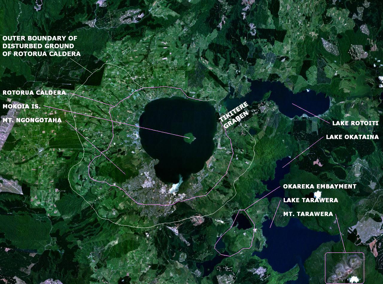
The Rotorua caldera has been dormant longer, with its main eruption occurring about 225,000 years ago, although lava dome extrusion has occurred within the last 25,000 years.[10][11]
Extent and geological context


The Taupō volcanic zone is approximately 350 kilometres (217 mi) long by 50 kilometres (31 mi) wide. Mount Ruapehu marks its southwestern end, while Whakaari / White Island is considered its northeastern limit.[12]
It forms a southern portion of the active Lau-Havre-Taupō back-arc basin, which lies behind the Kermadec-Tonga Subduction Zone.[13][14] Mayor Island and Mount Taranaki are recently active back arc volcanoes on the New Zealand extension of this arc. Mayor Island / Tūhua is the northern-most shield volcano adjacent to the New Zealand coast, and is believed to have been active in the last 1000 years. [15] It is formed from rhyolite magma.[16] It has a quite complex eruptive history but only with one definite significant Plinian eruption.[15] Mount Taranaki is an andesite cone and the most recent of four Taranaki volcanoes about 140 km (87 mi) west of the Taupō Volcanic Zone.[17]
Within the Taupō volcanic zone, intra-arc extension is expressed as normal faulting within a zone known as the Taupō Rift.[18] Volcanic activity continues to the north-northeast, along the line of the Taupō Volcanic Zone, through several undersea volcanoes in the South Kermadec Ridge Seamounts, then shifts eastward to the parallel volcanic arc of the Kermadec Islands and Tonga. Although the back-arc basin continues to propagate to the southwest, with the South Wanganui Basin forming an initial back-arc basin, volcanic activity has not yet begun in this region.[19]
South of Kaikōura the plate boundary changes to a transform boundary with oblique continental collision uplifting the Southern Alps / Kā Tiritiri o te Moana in the South Island. A subduction zone reappears southwest of Fiordland, at the southwestern corner of the South Island, although here the subduction is in the opposite direction. Solander Island / Hautere is an extinct volcano associated with this subduction zone, and the only one that protrudes above the sea.

Scientific study
Tectonics
Recent scientific work indicates that the Earth's crust below the Taupō Volcanic Zone may be as little as 16 kilometres thick. A film of magma 50 kilometres (30 mi) wide and 160 kilometres (100 mi) long lies 10 kilometres under the surface.[20][21] The geological record indicates that some of the volcanoes in the area erupt infrequently but have large, violent and destructive eruptions when they do.
Technically the zone is in the continental intraarc Taupō Rift. This has had three active stages of faulting in the last 2 million years with the modern Taupō rift evolving in the last 25,000 years after the massive Oruanui eruption being within two essentially inactive rift systems. These are the surrounding limits of the young Taupō Rift between 25,000 and 350,000 years and old Taupō Rift system whose northern boundary is now located well to the north of the other two being created between 350,000 and 2 million years.[2]
Faults
The multiple intra-rift faults are some of the most active in the country and some have the potential to create over magnitude 7 events. The fault structures are perhaps most well characterised related to the Ruapehu and Tongariro grabens. The recent deposits from major eruptions and lake features mean many potentially significant faults are uncharacterised, either completely (for example the 6.5 Mw 1987 Edgecumbe earthquake resulted in the mapping of the Edgecumbe fault for the first time) or frequency of events and their likely magnitude are not understood. It can not be assumed that just because the rate of expansion of the rift is greatest near the coast that this is where most significant tectonic earthquakes in terms of human risk will be. The Waihi Fault Zone south of Lake Taupō and associated with the Tongariro graben has a particular risk of inducing massive landslips which has caused significant loss of life and appears to be more active than many other faults in the zone.
Volcanism

The north (Whakatane Graben – Bay of Plenty) part of the zone is predominantly formed from andesitic magma[22][23] and represented by the continuously active Whakaari / White Island andesite–dacite stratovolcano. Although Strombolian activity has occurred the explosive eruptions are typically phreatic or phreatomagmatic.[24] The active emergent summit tops the larger, 16 kilometres (9.9 mi) × 18 kilometres (11 mi), submarine volcano with a total volume of 78 km3 (19 cu mi).[25][26][27][28]
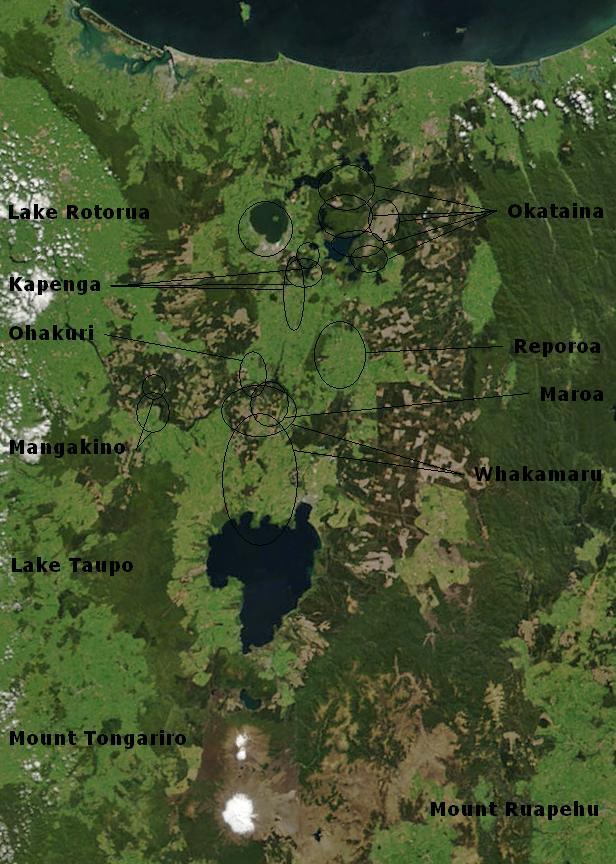
The central part of the zone is composed of eight caldera centres the oldest of which is the Mangakino caldera which was active more than a million years ago (1.62–0.91 Ma).[22] This produced ignimbrite that 170 km (110 mi) away in Auckland is up to 9 m (30 ft) thick.[29] Other than the now buried Kapenga caldera there are five caldera centres, Rotorua, Ohakuri, Reporoa, Ōkataina and Taupō. These have resulted from massive infrequent eruptions of gaseous very viscous rhyolite magma which is rich in silicon, potassium, and sodium and created the ignimbrite sheets of the North Island Volcanic Plateau. Less gaseous rhyolite magma dome building effusive eruptions have built features such as the Horomatangi Reefs or Motutaiko Island in Lake Taupō or the lava dome of Mount Tarawera. This later as part of the Ōkataina caldera complex is the highest risk volcanic field in New Zealand to man. [30] Mount Tauhara adjacent to Lake Taupō is actually a dacitic dome [31] and so intermediate in composition between andesite and rhyolite but still more viscus than basalt which is absent from the zone.
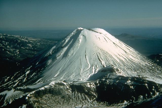
The southern part of the zone contain classic volcanic cone structure formed from andesite magma in effusive eruptions that cool to form dark grey lava if gas-poor or scoria if gas-rich of this part of the zone. Mount Ruapehu, the tallest mountain in the North Island, is a 150 km3 (36 cu mi) andesite cone surrounded by a 150 km3 (36 cu mi) ring-plain.[32] This ring plain is formed from numerous volcanic deposits created by slope failure, eruptions, or lahars. Northwest of Ruapehu is Hauhungatahi, the oldest recorded volcano in the south of the plateau,[32] with to the north the two prominent volcanic mountains in the Tongariro volcanic centre being Tongariro and Ngāuruhoe which are part of a single composite stratovolcano.
Risks

The most likely risk is earthquake associated with multiple active faults,[33] such as within the Taupō Fault Belt, but many faults will be uncharacterised as was the case with the 1987 Edgecumbe earthquake.[34] Earthquakes can be associated with landslides and inland or coastal tsunami that can result in great loss of life and both have happened on the Waihi Fault Zone. [35] The relative low grade volcanic activity of the andesite volcanoes at each end of the zone has resulted in recorded history in both direct loss of life and disrupted transport and tourism. The only high grade eruption in recorded history was atypically basaltic from Mount Tarawera and although very destructive is not likely to be a perfect model for the more typical and often larger rhyolitic events associated with the Taupō Volcano and the Ōkataina Caldera.[36] As mentioned earlier the Ōkataina caldera complex is the highest risk volcanic field risk in New Zealand to man[30] and the recent frequency of rhyolitic events there is not reassuring, along with the timescale of likely warning of such an event.[36] These eruptions are associated with tephra production that results in deep ash fall over wide areas (e.g. the Whakatane eruption of ~ 5500 years ago had 5 mm (0.20 in) ashfall 900 km (560 mi) away on the Chatham Islands) `[37] pyroclastic flows and surges, which rarely have covered large areas of the North Island in ignimbrite sheets, earthquakes, lake tsunamis, prolonged lava dome growth and associated block and ash flows with post-eruption lahars and flooding.[36]

Volcanoes, lakes and geothermal fields

The following Volcanic Centers belong to the Taupō Volcanic Zone:


Rotorua, Ōkataina , Maroa, Taupō, Tongariro and Mangakino.[38][39]
- Whakatāne Graben – Bay of Plenty
- Submarine Whakatāne Seamount 36°48′S 177°30′E
- Mayor Island / Tūhua 37°17′S 176°15′E
- Moutohora Island 37°51′23″S 176°58′24″E
- Whakaari / White Island 37°31′S 177°11′E
- Putauaki 38°06′S 176°48′E
- Geothermal field
- Kawerau Power Station 38°03′47″S 176°43′38″E
- Rotorua Volcanic Centre
- Rotorua Caldera, size: 22 km wide 38°05′S 176°16′E[40]
- Mount Ngongotahā 38.118973°S 176.198095°E
- Lakes
- Geothermal fields
- Tikitere/Hell's Gate 38.065°S 176.361°E
- Whakarewarewa 38°9′44″S 176°15′23″E
- Pōhutu Geyser (Te Puia)
- Ōkataina Volcanic Centre: The Haroharo and Tarawera complexes impounded the lakes against the outer margins of the Ōkataina Caldera. The Okareka Embayment and the Tarawera Volcanic Complex are inside the Haroharo Caldera which in turn is inside the Okataina Ring Structure, from Newhall (1988),[41] but newer maps show Okataina smaller.
- Ōkataina Caldera, size: roughly 27 x 20 km 38°13′S 176°30′E[42]
- Haroharo Caldera, size: 16 x 26 km[40]
- Haroharo volcanic complex, northern end of the Okataina Volcanic Center
- Mount Tarawera and Tarawera volcanic complex 38°13′S 176°30′E
- Okareka vent[43]
- Ōkareka Embayment 38°12′08″S 176°20′54″E
- Haroharo Caldera, size: 16 x 26 km[40]
- Rotomā Caldera[44] 38°05′S 176°35′E
- Lakes
- Lake Ōkataina 38°07′S 176°25′E
- Lake Tarawera 38°12′S 176°27′E
- Lake Rotokākahi (Green Lake) 38°13′S 176°20′E
- Lake Tikitapu (Blue Lake) 38°12′S 176°20′E
- Lake Ōkāreka 38°10′S 176°22′E
- Lake Rotomahana 38°16′S 176°27′E
- Lake Rotoiti 38°02′20″S 176°25′40″E
- Lake Rotomā 38°02′51″S 176°35′16″E
- Lake Rotoehu 38°1′S 176°32′E
- Geothermal fields
- Waimangu Volcanic Rift Valley 38°16′57″S 176°23′56″E
- Frying Pan Lake 38°17′01″S 176°23′42″E
- Waimangu Volcanic Rift Valley 38°16′57″S 176°23′56″E
- Ōkataina Caldera, size: roughly 27 x 20 km 38°13′S 176°30′E[42]
- Maroa Volcanic Centre: The Maroa Caldera formed in the north-east corner of the Whakamaru Caldera, and the Whakamaru Caldera partially overlaps with the Taupō Caldera on the South. The Waikato River course follows roughly the northern Maroa Caldera rim on one side. The town of Whakamaru and the artificial Lake Whakamaru, on the Waikato River, have the same name too.[40] The paired single event eruption of the Ohakuri Caldera at its north western limits with the Rotorua Caldera added later complexity after this classification was developed. Accordingly later naming, terms this the Whakamaru caldera complex.
- Ohakuri Caldera 38°22′41″S 176°01′08″E
- Maroa Caldera, size: 16 x 25 km 38°25′S 176°05′E[40]
- Puketarata volcanic complex 38°33′02″S 176°03′16″E[45]
- Reporoa Caldera, size: 10 x 15 km 38°25′S 176°20′E[40]
- Whakamaru Caldera, size: 30 x 40 km[40] 38.42°S 175.80°E
- Geothermal fields
- Waiotapu 38°21′34″S 176°22′11″E
- Wairakei 38°37′36″S 176°06′13″E
- Craters of the Moon (Karapiti) 38°38.8′S 176°4.1′E
- Orakei Korako 38°28′24″S 176°8′54″E
- Ngatamariki 38°32′50″S 176°11′45″E
- Rotokaua 38.627975°S 176.192191°E
- Ohaaki Power Station 38°31′37″S 176°17′31″E
- Taupō Volcanic Center
- Taupō Caldera, size: roughly 35 km wide 38°49′S 176°00′E[40]
- Ben Lomond rhyolite dome (contains obsidian) 38°35.7′S 175°57.2′E
- Lake Taupō 38°49′S 176°00′E
- Horomatangi Reefs 38.8°S 176.00°E
- Motutaiko Island 38.854°S 175.942°E
- Geothermal fields
- Tauhara-Taupō 38.967863°S 175.763380°E
- Tongariro Volcanic Centre: Lake Taupō, Kakaramea, Pihanga, Tongariro and Ruapehu are roughly aligned on the main fault.
- Kakaramea-Tihia Massif 38°59′20″S 175°42′30″E
- Pihanga 39°02′28.75″S 175°46′7″E
- Mount Tongariro and Tongariro volcanic complex 39°8′S 175°39′E
- Mount Ngāuruhoe, a main Tongariro vent 39°9′24.6″S 175°37′55.8″E
- Tama crater lakes, main Tongariro vents
- Upper Tama 39°11′07″S 175°37′20″E
- Lower Tama 39°12′09″S 175°36′24″E
- Mount Ruapehu 39°11′S 175°21′E
- Lakes
- Geothermal fields
- Ketetahi Springs 39°06′27″S 175°38′52″E
- Mangakino Volcanic Centre: The Mangakino Volcanic Center is the westernmost and oldest rhyolitic caldera volcano in the Taupō Volcanic Zone.[46] The course of the Waikato River crosses this area, between the artificial Lake Ohakuri (38°25′22″S 176°07′32″E), the town of Mangakino (38°23′S 175°47′E) and Hamilton.
- Artificial Lake Maraetai
Other important features of the TVZ include the Ngakuru and Ruapehu grabens.
Note

There is more recently a somewhat different classification:[22]
- North part: Whakatane Graben – Bay of Plenty
- Central part:
- West of the main fault zone:
- Mangakino caldera complex; may be transitional between Coromandel Volcanic Zone (CVZ) and Taupō Volcanic Zone (TVZ) (1.62 – 0.91 mio. years old)
- Kapenga caldera; lies between the Maroa caldera and the Rotorua caldera, it is completely buried under more recent tephra (circa 700,000 years old)
- Okareka Embayment, lies inside the northern end of the Kapenga caldera, but is more usually regarded as part of the recently active Okataina caldera complex[44]
- Rotorua single event caldera; Mamaku Ignimbrite (circa 225,000 years old)
- Main fault zone:
- Ōkataina caldera complex
- Whakamaru caldera complex
- Maroa caldera
- Ohakuri single event caldera
- Taupō caldera complex
- East of the main fault zone:
- Reporoa single event caldera; Kaingaroa Ignimbrite (circa 240,000 years old)
- West of the main fault zone:
- South part: Tongariro Volcanic Centre

See also
- Geology of New Zealand – Overview of the geology of New Zealand
- Geothermal areas in New Zealand
- Geothermal power in New Zealand – Overview of geothermal power in New Zealand
- List of volcanoes in New Zealand
- North Island Volcanic Plateau – A pyroclastic volcanic plateau on the North Island of New Zealand
- Rotorua Caldera
- Taupō Volcano
- Volcanology of New Zealand
References
- Cole, J.W.; Darby, D.J.; Stern, T.A. (1995). "Taupo Volcanic Zone and Central Volcanic Region: Backarc Structures of North Island, New Zealand". In Taylor, Brian (ed.). Backarc Basins: Tectonics and Magmatism. New York: Plenum. p. 3. ISBN 978-1-4615-1843-3.
- Villimor, P.; Berryman, K. R.; Ellis, S. M.; Schreurs, G.; Wallace, L. M.; Leonard, G. S.; Langridge, R. M.; Ries, W. F. (2017-10-04). "Rapid Evolution of Subduction-Related Continental Intraarc Rifts: The Taupo Rift, New Zealand". Tectonics. 36 (10): 2250–2272. Bibcode:2017Tecto..36.2250V. doi:10.1002/2017TC004715. S2CID 56356050.
- Waight, Tod E.; Troll, Valentin R.; Gamble, John A.; Price, Richard C.; Chadwick, Jane P. (2017-07-01). "Hf isotope evidence for variable slab input and crustal addition in basalts and andesites of the Taupo Volcanic Zone, New Zealand". Lithos. 284–285: 222–236. Bibcode:2017Litho.284..222W. doi:10.1016/j.lithos.2017.04.009. ISSN 0024-4937.
- Kósik, Szabolcs; Nemeth, Karoly; Danisik, Martin; Procter, Jonathan; Schmitt, Axel; Friedrichs, Bjarne; Stewart, Robert (2021-01-19). "Shallow subaqueous to emergent intra-caldera silicic volcanism of the Motuoapa Peninsula, Taupo Volcanic Zone, New Zealand – New constraints from geologic mapping, sedimentology and zircon geochronology". Journal of Volcanology and Geothermal Research. 411: 107180. doi:10.1016/j.jvolgeores.2021.107180. S2CID 233771486.
- Bonadonna, C.; Connor, C. B.; Houghton, B. F.; Connor, L.; Byrne, M.; Laing, A.; Hincks, T.K. (2005-03-15). "Probabilistic modeling of tephra dispersal: Hazard assessment of a multiphase rhyolitic eruption at Tarawera, New Zealand". Journal of Geophysical Research: Solid Earth. 110 (B3). Bibcode:2005JGRB..110.3203B. doi:10.1029/2003JB002896.
- David, Lowe (2006). "Polynesian settlement and impacts of volcanism on early Maori society" (PDF). In Lowe, D.J. (ed.). Guidebook for 'Land and Lakes' field trip, New Zealand Society of Soil Science Biennial Conference, Rotorua, held in 27–30 November 2006. Lincoln: New Zealand Society of Soil Science. pp. 50–55.
- Illsley-Kemp, Finnigan; Barker, Simon J.; Wilson, Colin J. N.; Chamberlain, Calum J.; Hreinsdóttir, Sigrún; Ellis, Susan; Hamling, Ian J.; Savage, Martha K.; Mestel, Eleanor R. H.; Wadsworth, Fabian B. (2021-06-01). "Volcanic Unrest at Taupō Volcano in 2019: Causes, Mechanisms and Implications". Geochemistry, Geophysics, Geosystems. 22 (6): 1–27. Bibcode:2021GGG....2209803I. doi:10.1029/2021GC009803.
- de Lange, Willem; Moon, Vicki (2016). Volcanic generation of tsunamis: Two New Zealand palaeo-events in Submarine Mass Movements and their Consequences (PDF). 56.
- Dunbar, Nelia W.; Iverson, Nels A.; Van Eaton, Alexa R.; Sigl, Michael; Alloway, Brent V.; Kurbatov, Andrei V.; Mastin, Larry G.; McConnell, Joseph R.; Wilson, Colin J. N. (2017-09-25). "New Zealand supereruption provides time marker for the Last Glacial Maximum in Antarctica". Scientific Reports. 7 (1): 12238. Bibcode:2017NatSR...712238D. doi:10.1038/s41598-017-11758-0. PMC 5613013. PMID 28947829.
- Milner, David M (2001). The structure and eruptive history of Rotorua Caldera, Taupo Volcanic Zone, New Zealand (Thesis).
- "Rotorua". Global Volcanism Program. Smithsonian Institution. Retrieved 2010-08-31.
- Gamble, J. A.; Wright, I. C.; Baker, J. A. (1993). "Seafloor geology and petrology in the oceanic to continental transition zone of the Kermadec-Havre-Taupo Volcanic Zone arc system, New Zealand". New Zealand Journal of Geology and Geophysics. 36 (4): 417–435. doi:10.1080/00288306.1993.9514588. Archived from the original on 2008-11-22.
- Caratori Tontini, F.; Bassett, D.; de Ronde, C. E. J.; Timm, C.; Wysoczanski, R. (2019). "Early evolution of a young back-arc basin in the Havre Trough" (PDF). Nature Geoscience. 12 (10): 856–862. Bibcode:2019NatGe..12..856C. doi:10.1038/s41561-019-0439-y. S2CID 202580942.
- Parson, L. M.; Wright, I. C. (1996). "The Lau-Havre-Taupo back-arc basin: A southward-propagating, multi-stage evolution from rifting to spreading". Tectonophysics. 263 (1–4): 1–22. Bibcode:1996Tectp.263....1P. doi:10.1016/S0040-1951(96)00029-7.
- Houghton, B.F.; Wilson, J. N. C; Weaver, S.D.; Lanphere, M.A.; Barclay, J (1995). "Mayor Island Geology". Volcanic Hazards at Mayor Island. [Palmerston North, NZ]: Ministry of Civil Defence. Volcanic Hazards Information Series 6.: 1–23.
- Houghton, Bruce F.; Weaver, S.D.; Wilson, J. N.; Lanphere, M.A. (1992). "Evolution of a quaternary peralkaline volcano: Mayor Island, New Zealand". Journal of Volcanology and Geothermal Research. 51 (3): 217–236. Bibcode:1992JVGR...51..217H. doi:10.1016/0377-0273(92)90124-V.
- Price, R. C.; Stewart, R. B.; Woodhead, J. D.; Smith, I. E. M. (1999). "Petrogenesis of High-K Arc Magmas: Evidence from Egmont Volcano, North Island, New Zealand". Journal of Petrology. 40 (1): 167–197. doi:10.1093/petroj/40.1.167.
- Holden, Lucas; Wallace, L.; Beavan, J.; Fournier, Nico; Cas, Raymond; Ailleres, Laurent; Silcock, David. (2015-07-28). "Contemporary ground deformation in the Taupo Rift and Okataina Volcanic Centre from 1998 to 2011, measured using GPS". Geophysical Journal International. 202 (3): 2082–2105. doi:10.1093/gji/ggv243.
- Villamor, P.; Berryman, K. R. (2006). "Evolution of the southern termination of the Taupo Rift, New Zealand". New Zealand Journal of Geology and Geophysics. 49: 23–37. doi:10.1080/00288306.2006.9515145.
- Easton, Paul (15 September 2007). "Central North Island sitting on magma film". The Dominion Post. Retrieved 16 March 2008.
- Heise, W.; Bibby, H.M.; Caldwell, T.G. (2007). "Imaging magmatic Processes in the Taupo Volcanic Zone (New Zealand) with Magnetotellurics" (PDF). Geophysical Research Abstracts. 9. 01311.
- Cole, J. W.; Spinks, K. D. (2009). "Caldera volcanism and rift structure in the Taupo Volcanic Zone, New Zealand". Special Publications. London: Geological Society. 327 (1): 9–29. Bibcode:2009GSLSP.327....9C. doi:10.1144/SP327.2. S2CID 131562598.
- Hiess, J; Cole, JW; Spinks, KD (2007). High-Alumina Basalts of the Taupo Volcanic Zone, New Zealand: Influence of the Crust and Crustal Structure (PDF). p. 36 – via Part of a BSc Project by Hiess, J. (University of Canterbury).
- Houghton, B. F.; Nairn, I. A. (1 December 1991). "The 1976–1982 Strombolian and phreatomagmatic eruptions of White Island, New Zealand: eruptive and depositional mechanisms at a 'wet' volcano". Bulletin of Volcanology. 54 (1): 25–49. Bibcode:1991BVol...54...25H. doi:10.1007/BF00278204. S2CID 128897275.
- Cole, J.W., Thordarson, T. and Burt, R.M., 2000. Magma origin and evolution of White Island (Whakaari) volcano, Bay of plenty, New Zealand. Journal of Petrology, 41(6), pp.867–895.
- Moon, V., Bradshaw, J. and de Lange, W., 2009. Geomorphic development of White Island Volcano based on slope stability modelling. Engineering Geology, 104(1–2), pp.16–30.
- Jimenez, C., 2015. Magmatic-hydrothermal system at White Island volcano, North Island, New Zealand. in M. Calder, ed., pp. 35–46, JCU SEG Student Chapter New Zealand, North Island Field Trip 2015 Guide Book. Queensland, Australia: James Cook University SEG Student Chapter, Society of Economic Geologists, Inc.
- Duncan, A.R. (1970). The petrology and petrochemistry of andesite volcanoes in Eastern Bay of Plenty, New Zealand (PDF) (Thesis). Victoria University of Wellington, New Zealand. 362.
- "GUIDEBOOK FOR LAND AND LAKES FIELD TRIP". New Zealand Society of Soil Science. 2006-11-28.
- Doherty, Angela Louise (2009). "Blue‐sky eruptions, do they exist? Implications for monitoring New Zealand's volcanoes" (PDF). University of Canterbury. Retrieved 2022-06-07.
- Volcanic Hazards Working Group of the Civil Defence Scientific Advisory Committee, which includes scientists from the Institute of Geological and Nuclear Sciences and the Universities, Number seven "Taupo Volcanic Centre" Archived 2006-10-06 at the Wayback Machine
- Leonard, Graham S.; Cole, Rosie P.; Christenson, Bruce W.; Conway, Chris E.; Cronin, Shane J.; Gamble, John A.; Hurst, Tony; Kennedy, Ben M.; Miller, Craig A.; Procter, Jonathan N.; Pure, Leo R.; Townsend, JDougal B.; White, James D. L.; Wilson, Colin J. N. (2021-05-02). "Ruapehu and Tongariro stratovolcanoes: a review of current understanding". New Zealand Journal of Geology and Geophysics. 64 (2–3): 389–420. doi:10.1080/00288306.2021.1909080. S2CID 235502116.
- "Villamor, P.; Ries, W.; Zajac, A. Rotorua District Council Hazard Studies: Active fault hazards. GNS Science Consultancy Report" (PDF). 2010.
- Franks, C.A.M.; Beetham, R.D.; Salt, G.A. (1989). "Ground damage and seismic response resulting from the 1987 Edgecumbe earthquake, New Zealand". New Zealand Journal of Geology and Geophysics. 32 (1): 135–44. doi:10.1080/00288306.1989.10421397.
- Gómez‐Vasconcelos, Martha; Villamor, Pilar; Procter, Jon; Palmer, Alan; Cronin, Shane; Wallace, Clel; Townsend, Dougal; Leonard, Graham (2018). "Characterisation of faults as earthquake sources from geomorphic data in the Tongariro Volcanic Complex, New Zealand". New Zealand Journal of Geology and Geophysics. 62: 131–142. doi:10.1080/00288306.2018.1548495. S2CID 134094861.
- Darragh, Miles Benson (2004). Eruption Processes of the Okareka and Rerewhakaaitu eruption episodes; Tarawera Volcano, New Zealand (PDF) (Thesis).
- Holt, Katherine A.; Lowe, David J.; Hogg, Alan G.; Wallace, R. Clel (2011). "Distal occurrence of mid-Holocene Whakatane Tephra on the Chatham Islands, New Zealand, and potential for cryptotephra studies". Quaternary International. 246 (1–2): 344–351. doi:10.1016/j.quaint.2011.06.026. hdl:10289/5454. ISSN 1040-6182.
- Cole, J.W. (1990). "Structural control and origin of volcanism in the Taupo volcanic zone, New Zealand". Bulletin of Volcanology. 52 (6): 445–459. Bibcode:1990BVol...52..445C. doi:10.1007/BF00268925. S2CID 129091056.
- "New Zealand".
- http://www.volcano.si.edu/world/largeeruptions.cfm [bare URL]
- Newhall, Christopher G.; Dzurisin, Daniel (1988). "Historical unrest at large calderas of the world". USGS Bulletin. 1855: 1108. Citing Scott, B.J. (1986). Gregory, J.G.; Watters, W.A. (eds.). "Volcanic hazards assessment in New Zealand: Monitoring at Okataina Volcanic Centre". New Zealand Geol. Surv. Rec. 10: 49–54.
- Okataina Volcanic Center, New Zealand
- Nairn, I.A. (2002). Geology of the Okatania Volcanic Centre. Geological Map 25. Institute of Geological and Nuclear Sciences. p. 156.
- Hodgson, K. A.; Nairn, I. A. (August 2004). "The Sedimentation and Drainage History of Haroharo Caldera and The Tarawera River System, Taupo Volcanic Zone, New Zealand" (PDF). Operations Publication 2004/03. Environment Bay of Plenty: 7. ISSN 1176-5550. Archived from the original (PDF) on 2010-05-22.
- Kósik, S.; Németh, K.; Lexa, J.; Procter, J.N. (2019). "Understanding the evolution of a small-volume silicic fissure eruption: Puketerata Volcanic Complex, Taupo Volcanic Zone, New Zealand". Journal of Volcanology and Geothermal Research. 383: 28–46. doi:10.1016/j.jvolgeores.2017.12.008. ISSN 0377-0273. S2CID 134914216.
- Krippner, Stephen J. P.; Briggs, Roger M.; Wilson, Colin J. N.; Cole, James W. (1998). "Petrography and geochemistry of lithic fragments in ignimbrites from the Mangakino Volcanic Centre: implications for the composition of the subvolcanic crust in western Taupo Volcanic Zone, New Zealand". New Zealand Journal of Geology and Geophysics. 41 (2): 187–199. doi:10.1080/00288306.1998.9514803.
External links
- Further information on Taupō volcanics
- Tectonic plate information
- Earthquake risks
- New Zealand's volcanoes: The Taupō Volcanic Centre
- New Zealand's volcanoes: The Okataina Volcanic Centre
- Maps
- Environment Waikato, Regional Council, map
- Lowe, D.J. (ed.). Guidebook for 'Land and Lakes' field trip, New Zealand Society of Soil Science Biennial Conference, Rotorua, held in 27–30 November 2006 (PDF). Lincoln: New Zealand Society of Soil Science. p. 63.
- Hiess, J; Cole, JW; Spinks, KD (2007). High-Alumina Basalts of the Taupo Volcanic Zone, New Zealand: Influence of the Crust and Crustal Structure (PDF). p. 36. Map modified from: Spinks, Karl D; Acocella, Valerio; Cole, Jim W; Bassett, Kari N (2005-06-15). "Structural control of volcanism and caldera development in the transtensional Taupo Volcanic Zone, New Zealand". Journal of Volcanology and Geothermal Research. 144 (1–4): 7–22. Bibcode:2005JVGR..144....7S. doi:10.1016/j.jvolgeores.2004.11.014.
- Geological Society of New Zealand & New Zealand Geophysical Society - Fieldtrip 2
- Houghton, Bruce F. (2007). Field Guide - Taupo Volcanic Zone (PDF).
- New Zealand, Taupō and Coromandel volcanic zones
- Newhall, Christopher G.; Dzurisin, Daniel (1988). "Historical unrest at large calderas of the world". USGS Bulletin. 1855: 1108.
- The Taupō Volcanic Zone with Māori Freehold Land (1995) - showing geothermal fields
| Authority control |
|
|---|
Другой контент может иметь иную лицензию. Перед использованием материалов сайта WikiSort.org внимательно изучите правила лицензирования конкретных элементов наполнения сайта.
WikiSort.org - проект по пересортировке и дополнению контента Википедии