geo.wikisort.org - Reservoir
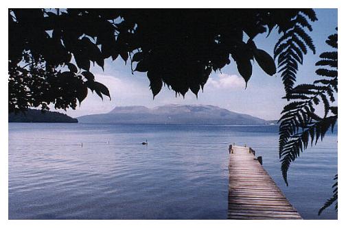
Lake Tarawera is the largest of a series of lakes which surround the volcano Mount Tarawera in the North Island of New Zealand. Like the mountain, it lies within the Okataina caldera. It is located 18 kilometres (11 mi) to the east of Rotorua, and beneath the peaks of the Tarawera massif i.e. Wahanga, Ruawahia, Tarawera and Koa. The lake's surface area is 39 square kilometres (15 sq mi).
This article needs additional citations for verification. (February 2009) |
| Lake Tarawera | |
|---|---|
 Lake Tarawera | |
 Lake Tarawera  Lake Tarawera | |
| Location | Rotorua Lakes, Bay of Plenty Region, North Island |
| Coordinates | 38°12′S 176°27′E |
| Basin countries | New Zealand |
| Max. length | 11.4 km (7.1 mi)[1] |
| Max. width | 9.0 km (5.6 mi)[1] |
| Surface area | 41.0 km2 (15.8 sq mi)[1] |
| Average depth | 57.0 m (187.0 ft)[1] |
| Max. depth | 87.5 m (287 ft)[1] |
| Surface elevation | 298 m (978 ft)[1] |
| References | [1] |

Geography
The lake was substantially affected by the eruption of Mount Tarawera on 10 June 1886.[2][3][4] The lake outlet was blocked for two decades and the lake level increased.[5] The eruption killed over 150 people, and buried the Māori village of Te Wairoa on the southwest shore of the lake.[6][7]

Also assumed destroyed were the famed Pink and White Terraces. However, in February 2011 a team mapping the lake floor discovered what appeared to be part of the Pink Terraces. The lowest two tiers of the terraces were reportedly found in their original place at 60 metres (200 ft) deep (too deep for scuba diving without special gas gear). Subsequently, a portion of the White Terraces was reportedly rediscovered in June 2011. The announcement of the rediscovery of the White Terraces coincided with the 125th anniversary of the eruption of Mt. Tarawera in 1886. It was thought that the rest of the terraces may be buried in sediment rather than having been destroyed.
More recent research questions these earlier findings and reports the Pink and White terrace spring sites instead lie on land (along with a lesser-known Black Terrace spring).[8][9][10][11]
Tarawera means "Burnt Spear", named by a visiting hunter who left his bird spears in a hut and on returning the following season found both the spears and hut had been burned down completely.[12]
The lake is filled primarily by water flowing through the volcanic rocks and ashes, only about 42% being from water flowing in streams, etc.[13] The flows are estimated to be -[14]

| Water flows to Lake Tarawera | litres/sec |
| Rotomahana to Tarawera (including 700 from Rerewhakaaitu and 67 from Okaro) | 3018 |
| Te Puroku No. 2 (from rock face spring)[13] | 384 |
| Okataina to Tarawera | 350 |
| Te Wairoa Stream | 310.6 |
| Okareka to Tarawera | 245 |
| Jetty Stream (ramp 4) | 226 |
| Rotokakahi to Tarawera (including 85 from Tikitapu) | 210 |
| Wairua Stream | 208 |
| Tarawera Peak Stream rockslide | 173.5 |
| Te Puroku No. 1 | 123 |
| Waitangi Stream | 102.3 |
| Tarawera Peak Stream spring | 91 |
| Tarawera Peak and Camp stream | 64.5 |
| Te Wairoa wharf spring | 26.6 |
| Te Whekau Stream | 19.5 |
| Orchard Stream | 15.6 |
| Other surface flows | 10 |
| Waitangui spring | 3.9 |
| Spencer Rd Ford Stream | 1.5 |
| Total surface inflow | 1760 |
| Total surface outflow (Tarawera River) | 7240 |
Lake Tarawera is home to eels and rainbow trout. During the summer it is popular for both fishing and water sports, and also camping as there a number of hot water beaches.
The main hot water sources are in the southern section of the lake at the Wairua Stream, Hot Water Beach and Te Puha and Tarawera fumaroles. There is also a small geothermal area at Humphrey's Bay, to the south of Lake Okataina.[13] Water varies between 37 °C (99 °F) and 90 °C (194 °F).[14]
Lake Tarawera's outflow is at its north east end, into the Tarawera River, which flows northeast into the Bay of Plenty.
References
- Lowe, D.J.; Green, J.D. (1987). Viner, A.B. (ed.). Inland waters of New Zealand. Wellington: DSIR Science Information Publishing Centre. pp. 471–474. ISBN 0-477-06799-9.
- Royal Society of New Zealand (1984), Journal of the Royal Society of New Zealand, Vol. 14–15 p. 121. ISSN 0303-6758
- Keam, Ron (1988). Tarawera: The Volcanic Eruption of 10 June 1886. Auckland: R. F. Keam.
- Nairn, I. and Houghton, B. F. (1986) "Tarawera- the 1886 eruption" in Perry, J. F. (Ed.) Tarawera Eruption Centennial Exhibition 1886–1986, Rotorua District Council, Rotorua, 204
- Hodgson, K. A. and Nairn, I. (2005) "The c. AD 1315 syn-eruption and AD 1904 post-eruption breakout floods from Lake Tarawera, Haroharo caldera, North Island, New Zealand" New Zealand Journal of Geology and Geophysics, 48, 491–506.
- Flagler, Bette (2005). Adventure Guide New Zealand, Hunter Publishing (NJ), Illustrated ed. p. 205. ISBN 1-58843-405-2
- Keam, Ron (2004). Dissolving Dreams. Auckland: RE. F. Keam. pp. 33–34.
- Bunn, Rex; Nolden, Sascha (7 June 2017). "Forensic cartography with Hochstetter's 1859 Pink and White Terraces survey: Te Otukapuarangi and Te Tarata". Journal of the Royal Society of New Zealand. 48: 39–56. doi:10.1080/03036758.2017.1329748. ISSN 0303-6758. S2CID 134907436.
- Bunn, Nolden, Rex, Sascha (December 2016). "Te Tarata and Te Otukapuarangi: Reverse engineering Hochstetter's Lake Rotomahana Survey to map the Pink and White Terrace locations". Journal of New Zealand Studies. NS23: 37–53.
- Bunn, A. R., Davies, N. and Stewart, D. (2018) "Dr Hochstetter’s Lost Survey” Surveying+Spatial, 94, 5–13.
- Bunn, A. R. (2019) "Hochstetter’s Survey of the Pink and White Terraces: The Final Iteration” Surveying+Spatial, 99, 30–35
- Paul Smitz, Sandra Bao, Pete Cruttenden (2005). Australia & New Zealand on a shoestring, Lonely Planet Publications, 1st ed. p. 603. ISBN 1-74059-646-3
- White, P.; Toews, M.; Tschritter, C.; Lovett, A. (2016). "Nitrogen discharge from the groundwater system to lakes and streams in the greater Lake Tarawera catchment, GNS Science Consultancy Report 2015/108" (PDF). Bay of Plenty Regional Council.
- Gillon, Nicolas; White, Paul; Hamilton, David; Warwick, Silvester (2009). "Groundwater in the Okataina caldera: Model of future nitrogen loads to Lake Tarawera" (PDF). University of Waikato.
External links
 Media related to Lake Tarawera at Wikimedia Commons
| Authority control: National libraries |
|---|
На других языках
[de] Lake Tarawera
Der Lake Tarawera ist der mit 39 km² Fläche größte einer Reihe von Seen um den Vulkan Mount Tarawera in der Bay of Plenty auf der Nordinsel Neuseelands. Berg und Seen liegen in der in den letzten 300.000 Jahren entstandenen Okataina-Caldera. Er liegt etwa 18 km östlich von Rotorua und fünf Kilometer westlich des Berges.- [en] Lake Tarawera
[fr] Lac Tarawera
Le lac Tarawera est un lac de l'Île du Nord de la Nouvelle-Zélande, situé à Rotorua.[it] Lago Tarawera
Il lago Tarawera è il più grande fra i laghi che circondano il monte Tarawera, nella regione di Bay of Plenty nell'Isola del Nord della Nuova Zelanda.[ru] Таравера (озеро)
Тараве́ра[1] (англ. Tarawera) — кратерное озеро на Северном острове в регионе Бей-оф-Пленти Новой Зеландии[2].Другой контент может иметь иную лицензию. Перед использованием материалов сайта WikiSort.org внимательно изучите правила лицензирования конкретных элементов наполнения сайта.
WikiSort.org - проект по пересортировке и дополнению контента Википедии