geo.wikisort.org - Mountains
Ragged Mountain (2,286 feet (697 m) above sea level) is a low mountain with numerous knobby summits in the towns of Danbury and Andover in central New Hampshire. It is home to the Ragged Mountain ski resort.
| Ragged Mountain | |
|---|---|
 Ragged Mountain as seen from Mount Kearsarge | |
| Highest point | |
| Elevation | 2,286 ft (697 m) |
| Coordinates | East summit (The Pinnacle): 43°28′5″N 71°49′46″W West summit (ski resort): 43°28′20″N 71°50′44″W |
| Geography | |
| Location | Andover, New Hampshire, U.S. |
| Topo map | USGS Andover |
Geography
In his book, The History of the Town of Andover, John R. Eastman describes Ragged Mountain as a "truly ragged pile of ledge and boulder, crag and cliff, hill and ravine."[1] An east–west running, detached mountain, Ragged Mountain contains two prominent peaks separated by a shallow notch. The tallest peak, The Pinnacle, lies in the town of Andover at 2,286 feet (697 m); the second peak, at the top of Ragged Mountain Ski Resort, is 2,225 feet (678 m) and sits in the town of Danbury.
The Bulkhead, a 300-foot (91 m) granite cliff, juts out on the east end of Ragged Mountain. A seldom-used rock climbing destination, The Bulkhead is also the last place peregrine falcons have nested in the Sunapee-Kearsarge region of New Hampshire.[2] The Bulkhead can be reached from The Bulkhead Trail at the headwaters of Mitchell Brook on Proctor Academy's campus. From the Andover town green, the hike takes roughly an hour and twenty minutes.
The 75-mile (120 km) long Sunapee–Ragged–Kearsarge (SRK) Greenway, a hiking trail, traverses the summit and subsidiary knobs of the mountain. The trailheads are at Proctor Academy on NH Route 11 in Andover and, on the northern side, on New Canada Road in Danbury.
Hydrology
The northern side of Ragged Mountain drains into the Smith River via Bog Brook. The western, southern, and eastern sides of the mountain drain into the Blackwater River. The entire mountain is situated within the Merrimack River watershed, which empties into the Gulf of Maine (Atlantic Ocean) near Newburyport, Massachusetts.
Water bodies around the base of the mountain are (listed counter-clockwise, starting to the west) Eagle Pond, Cold Pond, Hopkins Pond, Elbow Pond, and Bog Pond.
Gallery
 View of Ragged Mountain from Elbow Pond
 South side of Ragged Mountain from Winslow State Park
 The Pinnacle (2,286 ft) and The Bulkhead (1600 ft)
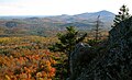 View of Mount Kearsarge from The Bulkhead on Ragged Mountain
 The Bulkhead cliffs on Ragged Mountain


Notes
- The History of the Town of Andover. Rumford Print. Company. 1910. Retrieved 2008-11-02 – via Internet Archive.
ragged mountain bulkhead.
- "State of New Hampshire Wildlife Plan" (PDF). State of New Hampshire. Archived from the original (PDF) on 2007-01-08. Retrieved 2008-11-02.
External links
| Wikimedia Commons has media related to Ragged Mountain, New Hampshire. |
- SRK Greenway - Ragged Mountain map
- Ragged Mountain - FranklinSites.com Hiking Guide
- Peakbagger.com: Ragged Mountain, New Hampshire
- Proctor Academy
- U.S. Geological Survey Geographic Names Information System: Ragged Mountain
На других языках
[de] Ragged Mountain (New Hampshire)
Der Ragged Mountain ist ein zweigipfeliger Berg zwischen Danbury und Andover, Merrimack County, New Hampshire. Seine Höhe beträgt 691 Meter.[1] Er gehört zu den Appalachian Mountains, im engeren Sinne zum Hochland Neuenglands,[2] und liegt im Einzugsgebiet des Merrimack River, der in Newburyport, Massachusetts, in den Golf von Maine mündet. An seiner Nordseite befindet sich ein Skigebiet, das seit 1968 existiert und einen Golfplatz und ein Hotel umfasst. Über den Gipfel verläuft ein Wanderweg, der Sunapee-Ragged-Kearsarge Greenway. Im Südosten liegt der Bulkhead, eine Granitformation, ein Nistplatz für Wanderfalken.[3] Die Staatsstraße NH 104 trägt den Namen Ragged Mountain Highway.[4] Sie verbindet Danbury und das Skigebiet mit dem I-93 bei New Hampton.- [en] Ragged Mountain (New Hampshire)
Другой контент может иметь иную лицензию. Перед использованием материалов сайта WikiSort.org внимательно изучите правила лицензирования конкретных элементов наполнения сайта.
WikiSort.org - проект по пересортировке и дополнению контента Википедии