geo.wikisort.org - Mountains
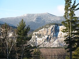
North Moat Mountain is a mountain located in Carroll County, New Hampshire. North Moat is flanked to the south by Middle Moat Mountain, and to the west by Big Attitash Mountain.
| North Moat Mountain | |
|---|---|
 North Moat Mountain, looking southwest from Intervale. Cathedral Ledge cliff is in right middleground. | |
| Highest point | |
| Elevation | 974 m (3,196 ft) |
| Prominence | 320 m (1,050 ft)[1] |
| Coordinates | 44°2.59′N 71°12.88′W |
| Geography | |
| Location | Carroll County, New Hampshire, U.S. |
| Topo map | USGS North Conway West |
North Moat Mountain stands within the watershed of the upper Saco River, which drains into the Gulf of Maine at Saco, Maine. The northwest side of North Moat Mtn. drains into Lucy Brook, thence into the Saco River. The east side of North Moat drains into Moat Brook, thence into the Saco. The southwest side of North Moat drains into Deer Brook, thence into the Swift River, a tributary of the Saco.
See also
- List of mountains in New Hampshire
- White Mountain National Forest
Notes
- Key col at 2,140±20 ft at 44.02761°N 71.28214°W.
External links
- U.S. Geological Survey Geographic Names Information System: North Moat Mountain
- PeakBagger.com: North Moat Mountain
Текст в блоке "Читать" взят с сайта "Википедия" и доступен по лицензии Creative Commons Attribution-ShareAlike; в отдельных случаях могут действовать дополнительные условия.
Другой контент может иметь иную лицензию. Перед использованием материалов сайта WikiSort.org внимательно изучите правила лицензирования конкретных элементов наполнения сайта.
Другой контент может иметь иную лицензию. Перед использованием материалов сайта WikiSort.org внимательно изучите правила лицензирования конкретных элементов наполнения сайта.
2019-2025
WikiSort.org - проект по пересортировке и дополнению контента Википедии
WikiSort.org - проект по пересортировке и дополнению контента Википедии