geo.wikisort.org - Mountains
Mount Liberty[1] is a 4,459-foot-high (1,359 m) mountain in the White Mountains of New Hampshire. Overlooking Franconia Notch, it is part of Franconia Ridge, the second highest mountain group in the Whites after the Presidential Range. It lies south of Mount Lafayette, the highest summit along the ridge, and is listed among the Appalachian Mountain Club's "four-thousand footers".
| Mount Liberty | |
|---|---|
 Summit of Mount Liberty | |
| Highest point | |
| Elevation | 4,459 ft (1,359 m) |
| Prominence | 379 ft (116 m)[1] |
| Listing | White Mountain 4000-Footers |
| Coordinates | 44°06′57″N 71°38′32″W |
| Geography | |
| Location | Grafton County, New Hampshire, U.S. |
| Parent range | Franconia Range |
| Climbing | |
| Easiest route | Hike |
Gallery
 Mount Liberty seen from the slide on Owl's Head
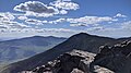 A view of Mt. Liberty from the summit of Mt. Flume
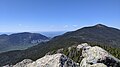 A view to the North-Northwest from the summit of Mt. Liberty
 Panoramic view from the summit of Mt. Liberty
 USGS survey marker at the top of Mt. Liberty


See also
References
- "Mount Liberty, New Hampshire". Peakbagger.com. Retrieved 2008-04-11.
This New Hampshire state location article is a stub. You can help Wikipedia by expanding it. |
Текст в блоке "Читать" взят с сайта "Википедия" и доступен по лицензии Creative Commons Attribution-ShareAlike; в отдельных случаях могут действовать дополнительные условия.
Другой контент может иметь иную лицензию. Перед использованием материалов сайта WikiSort.org внимательно изучите правила лицензирования конкретных элементов наполнения сайта.
Другой контент может иметь иную лицензию. Перед использованием материалов сайта WikiSort.org внимательно изучите правила лицензирования конкретных элементов наполнения сайта.
2019-2025
WikiSort.org - проект по пересортировке и дополнению контента Википедии
WikiSort.org - проект по пересортировке и дополнению контента Википедии